History of Woodbridge up to 1560
After the Danes invaded Britain in 865 they settled in East Anglia and the northern areas of the Britain. Because the Danes destroyed many charters and deeds, all written documents relating to Woodbridge are post the invasion. When Woodbridge was first mentioned in 959 it was called Uderdryge. Later it was written as:- Uderbrige, Vdebryge, Vdebriga, Vdebriga, Wudebryge, Wudebrige and Wdebrige.
The most likely pronunciation of the name of the settlement is Wudebryge. This is Old Norse for wooden jetty or wooden bridge. The name Wooden Jetty would convey useful knowledge to people sailing up an estuary lined by extensive marshes, whereas any bridge would have been over one of the brooks that ran either side of the ridge on which the church stands, rather than across the much wider Deben estuary. As it is unlikely that such a bridge would be important enough to be conveyed in the name of the settlement, wooden jetty is probably the origin of the name of the town.
The adjacent settlement of Kingston was a royal manor. It was where people came to pay their food rents to the king. The manor was granted to the Monastery at Ely by King Edgar in 970.
Woodbridge in Domesday Book
The earliest detailed information about land ownership in England is to be found in Domesday Book, a statistical survey of England in 1086. It gives detail of land ownership before and after the Norman Conquest. Some plots of land are referred to as Manors but most are not.
The survey for Suffolk lists (i) the size of each plot of land within Woodbridge (ii) the number of men who worked on each plot and (iii) the Norman Lord who was granted each plot by the King after the Norman Conquest. The plots were held by various Barons, chief of whom were Geoffrey de Manderville, Robert Malet and Roger Bigod. The biggest landowner was Robert Malet and his lands eventually passed, by matrimonial alliance, to the Bigod family who, by then, were the Earls of Norfolk. They administered their estates from their castles at Ipswich, Bungay, Walton and Framlingham.
The castles in Framlingham and Walton were linked by 'Bigod's Way' which skirted the north of Woodbridge and there was a spur linking it to the church and quay at Woodbridge.
By 1200 there had been a considerable number of land transfers and the land held by the Norman Lords and Bishops had been split up into manors. These manors were not static or immutable entities. They changed overtime in shape and size. Land could be either sold, purchased or transferred and it is not unusual to find that a manor held plots of land detached from its core.
Such changes happened in Woodbridge when an Augustinian priory was founded here in 1193. The Bigod family gave the priors land adjacent to the Church for their priory. The priory was also given land in Woodbridge, Hasketon, Burgh and other places to provide an income.
In 1171 Baldwin of Ufford granted tithes, from his tide mill in Woodbridge, to the Cannons of Butley Priory. By 1213 these tithes had been transferred to Woodbridge Priory and, in 1436, the Lord of the Manor of Woodbridge Ufford granted the “Key and Pool” to the Prior of Woodbridge.
The Priory acquired market rights for Woodbridge in 1224. Soon after the market became established it is likely that Woodbridge began to flourish as a port because it was surrounded by a diverse agricultural area. Before this the main maritime activities on the Deben were at Goseford - an area just above the entrance to the Deben where there were a number of landing areas and secure anchorages. Goseford was a thriving maritime centre by the time of the Norman Conquest and there was a market at nearby Walton.
The priory was never very large and it shared the parish church with the inhabitants of Woodbridge.
Increased maritime trade made some Woodbridge Merchants very wealthy and they funded the building of the new Parish Church of St Mary’s in fine perpendicular style. Work on the church started in 1417 and finished in 1465. The original Anglo-Saxon church remained for the sole use of the priory and the two churches stood side by side.
The priory was dissolved in 1537 and the Anglo Saxon church was demolished 5 years later. It is likely that the priory's other buildings suffered the same fate at that time.
Woodbridge from 1224 to 1560
The national record of taxes paid for the years 1372, 1524 and 1674 show how the relative wealth of towns changed. Frank Grace used this data to assess the relative wealth of the towns in Suffolk. The tables he produced are reproduced on the right. They show that, in 1327, Woodbridge was the 24th richest town in Suffolk. By 1524 it was the 11th and by 1674 it had become the 5th richest town.
In 1536 Woodbridge Priory was amongst the first group of monasteries to be dissolved. Most of the dissolved monasteries were given to supporters of the King and, in 1536, the Duke of Norfolk, who had already received a gift of 13 rich abbeys, requested Woodbridge Priory as well. His request was refused and instead the Manor of Woodbridge Late Priory was leased for 21 years to Sir Anthony Wingfield. On his death in 1541 it was transferred to Sir John Wingfield. The Priory Church, the former parish church, was demolished in 1542 and it is probable that the Priory buildings suffered the same fate at that time.
The Court Rolls of the Manor of Woodbridge late Priory from 1547 to 1553 were studied by Vincent Redstone. They give details of changes in landownership and disputes over properties. Redstone published extracts from them in his book “Bygone Woodbridge” along with some details of what he thought the town was like at that time.
A far more detailed description of the town became available in 2002 when Anthony Breen published his translation of the 1560 Extent of the Manor of Woodbridge Late Priory. The Extent was produced in 1560 to detail the manor’s holdings and the revenues from these holdings. Four years later the Crown sold the Manor of Woodbridge Late Priory to Thomas Seckford.
Suffolk towns and village listed in order of their wealth in 1327 and 1524. The ports are shaded blue.

The 1560 Extent of the manor of Woodbridge late Priory lists each plot of land that made up the manor and the current and previous holders of each plot of land, and the holders of the land on which it abutted. It describes the type of building on each plot, or the use to which the land was put, and it gives the yearly payment due to the manor. The Extent is in effect a jigsaw with 538 pieces. By fitting them together it would be possible to produce a map of Woodbridge – well you could do if the Extent gave you the size of each piece.
Sadly the Extent only gives the size of about quarter of the buildings. But all is not lost because, if land abuts a road or lane, the Extent records the name of that road or lane. All of the highways, roads and lanes mentioned in the Extent still exist so it is possible to produce a map of Woodbridge in 1560 showing the approximate location of the buildings at that time.
From various entries in the Extent it is clear that the estuary at Woodbridge was lined by extensive salt marsh. During the period between the Norman Conquest and 1560 river walls had been built along parts of the lower reaches of the estuary in order to turn the salt marsh, which lined much of the estuary, into arable land. Construction of river walls higher up the estuary proceeded at a later date. At Woodbridge the marshes were “inned” gradually, but there is no definite record beyond a single reference in 1660.
Without a river wall the riverside area at Woodbridge would be liable to flooding in 1560, which is no doubt why most of the land below the Thoroughfare was being used for agriculture.
The names of the highways, roads and lanes mentioned in the 1560 Extent are listed below and the present names are shown in parentheses. Each road or lane on the list is numbered. These numbers can be used to identify the locations of all but one of roads or lanes on the map to the right of the list. This map also shows the locations of the parish boundary, the Great Fen and the common.
Brook Slade Lane is the the only highway mentioned in the Extent which can not be located with certainty. It is most likely that Brook Slade Lane ran alongside part of Spenyngs Brook which formed the boundary between Woodbridge and the hamlet of Kingston.
The lower part of what is now Pytches Rd did not exist in 1560. Sometime before 1813 a substantial brick mansion, called Mount Pleasant was built in Melton and access to it was via a lane which ran down the Processional Way (the parish boundary). In 1822, Thomas Pytches, the then owner of Mount Pleasant, improved the lane and named it Pytches Road.
List of the roads and lanes listed in the Extent
1 Lane leading from Byshopps Haugh towards the common of
Woodbridge (Part Pytches Rd and part Wilderness Lane
and Sun Lane)
2 Le Myllwaye leading from Fowerway Cross towards Naverne
Brook (Castle Street)
3 Baldrye Street (Angel Lane & Bredfield Street)
4 Fen Lane (Chapel Street)
5 Market (Market Hill)
6 Common Way from the market place towards Hasketon
(Theatre St & Burkitt Rd)
7 Lane leading to the lords pound called Le Pynfold
(Queens Head Lane)
8 Le Fishpond Street (Seckford Street)
9 Entrance to late priory
10 From the market at Woodbridge to Martlesham (Old Barrack Rd)
11 Church Gate Street (Church Street)
12 Church Lane (Turn Lane)
13 New Street (New Street)
14 Certain lane to Naverne Brook
15 Le Throughfare (Thoroughfare & Cumberland Street)
16 Thasea to the sea (Quay Street)
17 Old Kings Highway (Station Road & Quayside)
18 Kyngeston Waye (Kingston Rd)
19 Kings Highway (Melton Hill & Melton Rd)
20 Kings Highway (Ipswich Rd)
21 Brook Slade lane (possibly The Avenue and Jetty Ln)
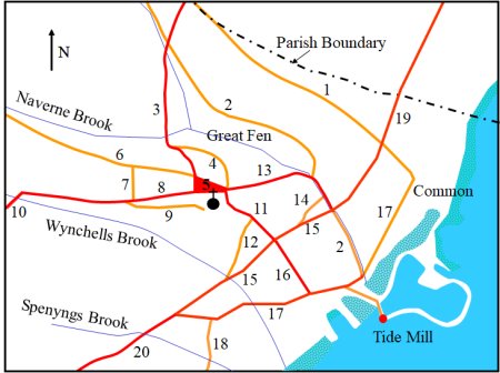
Map showing the locations of roads and lanes listed on the left and of the parish boundary, the Great Fen and the common and the tide mill.
On the highway from the market at Woodbridge to Martlesham (10), just before it crossed over Wychells Brook, there was entrance to "The Lord's Way" which ran to "Earl Bygot's Path". This path linked Earl Bygot's castles at Framlingham, Walton and Ipswich. The Lord's Way may have been the original route into the town. It later became known as Collett's Walk because of its association with Cornelius Collett, a churchwarden at St Mary's during the late eighteenth century. The Lord's Way appears to have joined Earl Bygot's Path at Gazebo Farm on the Grundisburgh Road but the evidence for this is not conclusive.
The Extent for 1560 lists three types of dwellings - capital messuages, messuages and cottages. There were 8 capital messuages, 94 messuages and 62 cottages. There were also 90 pieces of land associated with these dwellings. These pieces of land were variously described as gardens (22), hemp grounds (11), pightels (11) or just land (46). The hemp grounds would have been used to cultivate flax to make rope. Pightels were enclosed plots of land.
The Extent records the size of about half the plots used for dwellings and just over half of the plots of land associated with the dwellings. Because the record of plot size is incomplete it is not possible to locate the precise location of any dwelling. Nevertheless, it is possible to produce the map on the right. It shows the approximate location of all the dwellings recorded in the Extent for 1560. The lord of the manor of Woodbridge had an income of £9.66 from dwellings and £1.60 from plots of land associated with the dwellings.
The density of dwellings along the southern side of the Le Throughfare is clearly lower than on the northern side. This is probably because, within the boundary of Woodbridge, there were plots of land belonging to other manors. Such plots are only mentioned in the Extent if they abut plots of land belonging to the manor of Woodbridge late Priory. Most of the land belonging to other manors, principally the manor of Woodbridge Ufford, and the manor of Hasketon, was below the Le Throughfare.
A Subsidy Return of 1566 – basically a tax return – provides a way of estimating the percentage of houses which may be missing because they were not on land of the manor of Woodbridge late Priory. The Subsidy Return lists the names of 61 people in Woodbridge who were wealthy enough to pay the tax. Forty eight of them were listed in the Extent. The 13 who were not mentioned in the Extent may have lived in houses which were not on the land of the manor of Woodbridge late Priory. If that is the case the Extent of Woodbridge late Priory may only be listing 79% of the houses in Woodbridge.

Map showing the locations of the dwellings
recorded in the 1560 Extent.
A messuage "late called Le Guyld hall" was on what is now Church Street, just below the entrance to Turn Lane. Guild Halls like the monasteries were swept away by the Reformation. Vincent Redstone, an eminent historian, believes that the hall was for Guild of St Loy which rendered assistance to the poor and needy during the bitter days of winter.
Also swept away by the Reformation were crosses which stood in key places. The 1560 Extent mentions three locations where crosses formerly stood. One was at the junction of what is now Haugh Lane and the road from Melton to Bealings - the point where the parish boundaries of Melton, Hasketon and Woodbridge meet. There was another cross on the corner formed by what is now Church Street and Cumberland Street.
In his book Bygone Woodbridge Vincent Redstone mentions a cross on the Market and a cross in Bredfield Street, which "surpassed all the rest in grandeur". There are references to these crosses in the 1560 Extent but it is worth noting that the junction between Angel Lane, Chapel Street and Bredfield Street was called St Peter's Square on an 1811 map.
Seventeen commercial buildings were recorded in the Extent. These were 4 granaries, 3 barns, 4 warehouses, 4 shops, a brewery, a bake house and the Tide Mill. One of the four shops recorded also served as a tavern. The locations of these commercial buildings are shown on the map to the right.
That there are so few places of work mentioned in the 1560 Extent is at first surprising. But in medieval times many merchants and tradesmen would have carried on business from their homes and this was not recorded in the Extent.
Adjacent to the causeway which led to the Tide Mill there were two embankments which created quays. There was a third quay, referred to variously as Le Lord's Caye and Le Quave, which was on land belonging to the manor of Hasketon. This quay appears to have been at or near to Brook Slade lane. If so what is now called The Avenue and Jetty Lane could be what remains of Brook Slade lane.
The occupations of some those who held land in the manor are mentioned in the Extent. These occupations are listed below and the numbers of people in each occupation is given in brackets. The list is, however, certain to be incomplete. Many landholders held several properties which were sublet to people who were not mentioned in the Extent and whose occupation would thus not be recorded.
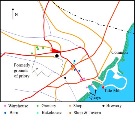
Map showing the locations of the commercial
buildings recorded in Extent of 1560.
Occupations listed in the 1560 Extent. The number of people in each occupation is shown in brackets

Before the Priory was dissolved the land around the Priory building contained a large garden for the priors and within it there was a large fish pond and a dovecote. Adjacent to the garden there was a capital messuage in which the prior's farmer lived. He manged the demesne, the land on which crops were grown, to produce a revenue to sustain the Priory. The other agricultural land of the Priory was divided in strips which were allocated to inhabitants of the manor who were prepared to do work on the demesne and/or to do other services for the Priory. In addition there was an area of common land on which inhabitants of the Priory were allowed to graze animals.
By 1560 two hundred and twenty three acres of land, which had previously been the demesne of the Manor of Woodbridge Priory, had been split between 9 people. Eight of them held their land on 21 year leases and made annual payments which totalled £54.28. The other was given his land for free. The demesne had been split into 31 parcels of land and in some cases the demesne land held by an individual were well spaced across the town. Each of the numbered green rectangles on the map to the right show the size and approximate location of the land held by all but one of those who held part of the demesne. The land holding of the remaining recipients of demesne are too small to be represented on the map. Five other people held parcels of demesne land which were in other manors.
In addition to the demesne there were 84 acres of land which was not associated with any of the buildings in the town. Presumably this land, which was split into 166 parcels, was what remained of land allocated to those inhabitants of the manor who were prepared to do work on the demesne and/or to do other services for the Priory. By 1560 this land was allocated to 13 individuals. There was also 13.5 acres of marshland which was split into 27 parcels. This land was held by 6 people who paid a total of £0.15 per annum.
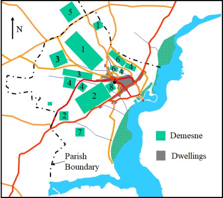
Map showing the size and approximate location and
parcels of demesne recorded in the 1560 Extent.
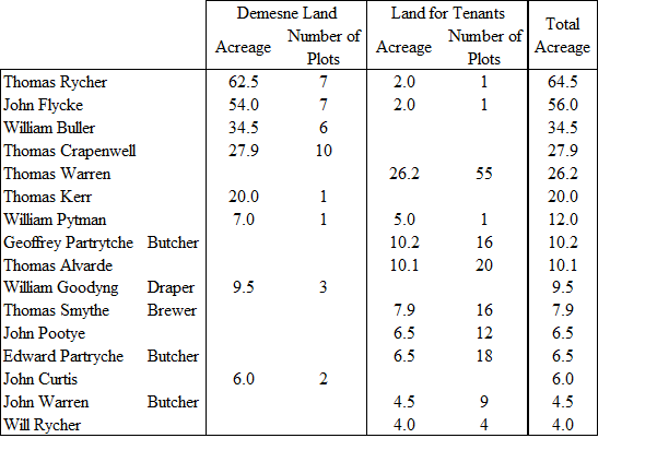
Below there is a list of the 16 biggest land holders. The Extent does give a complete record of the occupations of those who lived in the manor because many people held several dwellings and there is no record of those they sublet their addition dwellings to.
Table showing the landholdings of the 16 people who held the most land
In 1564 Thomas Seckford purchased the manor of Woodbridge late Priory from Elizabeth I and built his third house, which he named The Abbey, on the site of the former Priory.
Thomas Seckford was born in 1515 at Seckford Hall near Woodbridge. He became an eminent lawyer and was one of the two masters of the Court of Requests.
The function of Court of Requests was to "hear and settle poor men's complaints with as little cost as possible and to exercise compassion as far as this was compatible with speed and justice." Complaints were presented in the form of petitions to the Queen as she moved around the country and one of the two Masters of the Court of Requests always travelled with her. Thomas Seckford had a large house and estate in Clerkenwell (London) and another in Ipswich where he was MP for a number of years.
The manor of Woodbridge late Priory remained in the hands of the Seckford family until 1709.
Last edited: 2 Sept 23