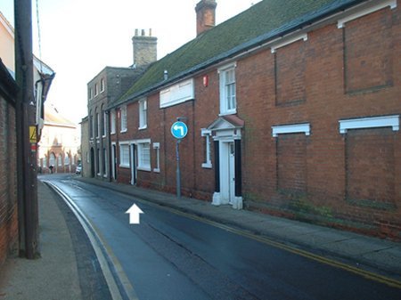
Seckford Street and Drybridge Hill
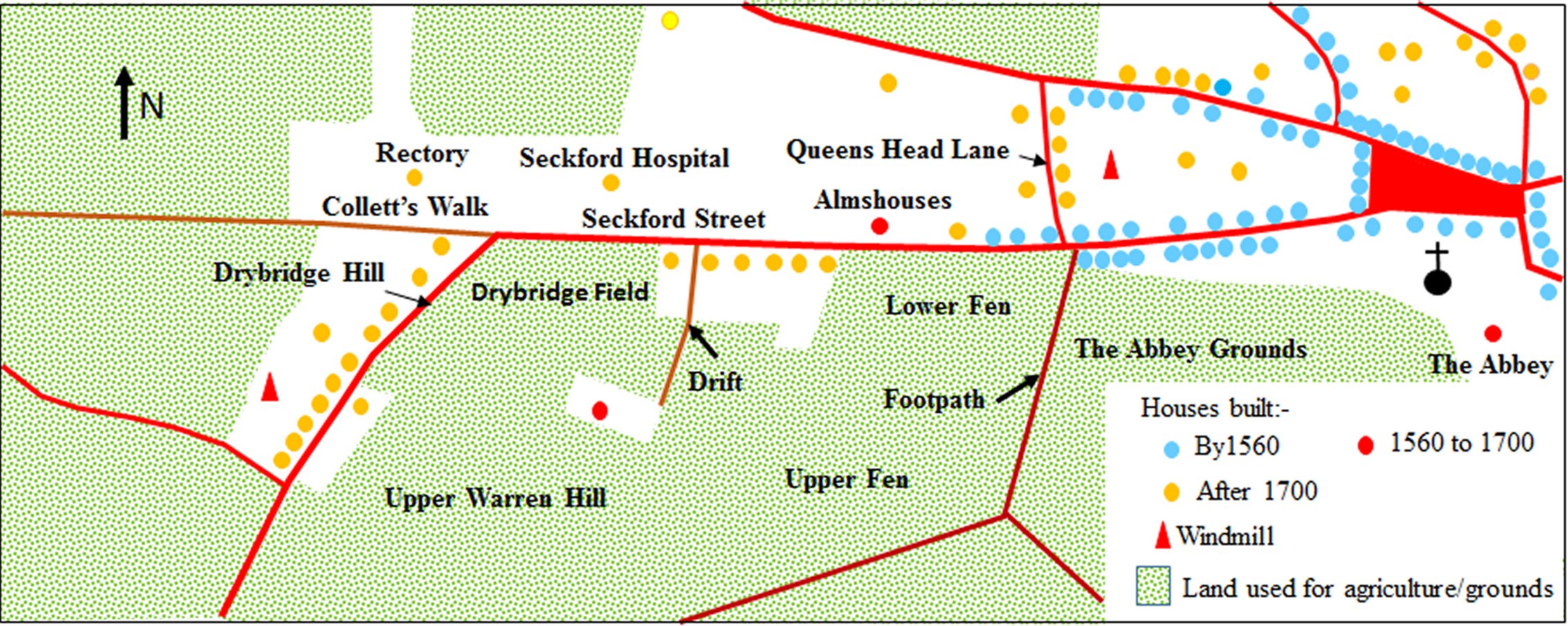
The Layout of the Streets in 1560
According to a survey of the manor of Woodbridge late Priory in 1560, Seckford Street was then called Le Fishpond Street. The pasture to the south of the street was named "Le Fishponds" because it contained the fishponds of the Augustinian Priory which, until 1542, had stood near St Mary's Church.
The map on the right shows the other features mentioned in the survey overlaid on the road layout from the 1881 OS map. The shaded green area was agricultural land which was part of the demesne of the manor. This land had formerly been retained by the lord of the manor but, by 1560, it was divided up into plots of various sizes which were rented out. The coloured dots mark the approximate locations of the 23 dwellings mentioned in the survey. Some of these dwellings were rented to more than one tenant.
"The entrance to the late priory" ran behind the houses on the southern side of Le Fishpond Street. All that remains of this entrance is a path now called Monks Walk. It was lined by an avenue of trees.
Below the area where the Priory had stood there were two plots of land described as "the garden of the priory" and "the pond yard". An 1827 map shows one fish pond along Wynchell's Brook but there may have been others which have subsequently been filled up.
About a third of the way along Le Fishpond Street there was a junction with "the way leading to the Lord's pound". This pound is where stray animals were held. It was midway along the lane which was later called Pound Lane.

Features mentioned in the 1560 survey overlaid on the road layout depicted in the 1881 OS map. Only part of Wynchell's Brook is shown on the OS map. The full course of the brook is taken from an earlier map.
At the western end of Le Fishpond Street there was a junction with "The Lord's Way" which ran to "Earl Bygot's Path". This path linked Earl Bygot's castles at Framlingham, Walton and Ipswich. The Lord's Way may have been the original route into the town. It later became known as Collett's Walk because of its association with Cornelius Collett, a churchwarden at St Mary's during the late eighteenth century. The Lord's Way appears to have joined Earl Bygot's Path at Gazebo Farm on the Grundisburgh Road but the evidence for this is not conclusive.
The road leading away from the junction of Le Fishpond Street and The Lord's Way was referred to as "The way leading from the market at Woodbridge towards Martlesham". Near this junction the road either passed over, or was washed over, by Wynchell's Brook. Although there is no mention of a bridge in the 1560 survey, an entry 9 years earlier in the Court Rolls of the manor refers to the mending of a bridge in Fishpond Street. By 1840 a large field abutting both roads was called "Drybridge Field" and, sometime during the next decade, that part of the road going up the hill from the junction was called Drybridge Hill. Much of Wynchell's Brook now flows in underground pipes.

View of Seckford Street from the top of St Mary's Church. The avenue of trees on the left line the path called Monk's Walk.
Thomas Seckford purchased the manor of Woodbridge late Priory in 1560. Shortly afterwards he built the house called 'The Abbey' on or near the site of the former priory and created "an enclosed park". In 1575 he obtained a licence from the Queen to found almshouses for the constant residence of thirteen poor men. They were to be accommodated in seven tenements he had just built on northern side of Le Fishpond Street. Seckford ordained that the 13 almsmen would have use of a nearby garden of about 3 acres and of a fountain or well in his "newly enclosed park in Woodbridge". It is probably because of the fountain or well that Le Fishpond Street was being called Well Street by 1587.
A free school for boys, which had been established by Thomas Arnott in 1577, on what is now Theatre Street, had to close in 1647 because of legal action over the terms of his will. The loss of the school was a serious blow to the town so, in 1662, three local people decided to create the Woodbridge Grammar School in a house on Well Street which abutted the north end of the churchyard. When the number of scholars increased the house was found to be too small, and it was enlarged in 1665, 1670 and 1694 by public subscription. The school flourished during the period 1796 to 1814 when it attracted pupils from the families of the officers stationed in garrison near the town but it then went into decline after the departure of the troops in 1814.
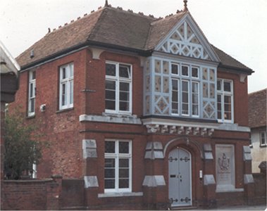
The house on Seckford Street in which
the Woodbridge Grammar School started
An 1820 map shows a windmill by the top of Drybridge Hill and it is known to have been in operation until at least 1830. The mill is also shown on an 1838 map but by then it appears to have been idle.
Sometime around 1831 a 'mansion' was built by the junction of Well Street and Collett’s Walk to serve as the rectory of St Mary's Church.
Following a fire the almshouses were rebuilt in 1733. Fifteen years later the nurses' residence was built alongside the almshouses because the old one proved to be inconveniently situated and needed repair.
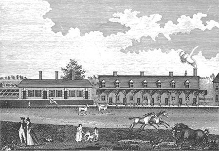
An engraving showing the almshouses (right)
and the nurses' residence (left) in 1792,
Seckford had endowed his almshouses with land in Clerkenwell (London) and, by 1832, the accumulated income from this property had greatly increased. This enabled the governors of the almshouses to double the number of almsmen. For their reception they commissioned the erection of a large and handsome Hospital with 32 bed-sitting rooms, each with a kitchen and a bath. Construction of the east wing started in 1834 and by 1839 the residents of the old Almshouses had moved in. Three years later the western wing and a lodge (for a porter/gardener) were completed and the massive gates and railings erected. The total cost of the new complex was about £28,000. The chapel between the east and west wings was completed in 1843 at a cost of £1200. There was seating accommodation for 150 to 200.
By 1840 the name Well Street was changed to Seckford Street presumably because it was dominated by the Seckford Hospital.

The Seckford Hospital circa 1900
The rate of growth of the population of England rose rapidly after 1750 and it was greatest in towns and cities because of migration from rural areas. The Poor Rate records for Woodbridge show that, over the period 1742 to 1830, the number of households in the town increased by 184%. The corresponding figure for Well Street and Drybridge Hill was even higher at 276%. The new houses erected along these roads in response to the rise in population are clearly shown on the 1840 tithe map.
A simplified version of that part of the tithe map, which covers Well Street and Drybridge Hill, is shown below. The red lines are streets and the brown lines are either footpaths or, in one case, a drift (a private road). The blue dots mark the locations of buildings in the area developed by 1560, while the orange dots are those erected after 1700. The white areas are the grounds associated with the buildings, while the stippled green areas were either used for agricultural purposes or were the grounds of The Abbey. The four fields in the area bounded by Seckford Street and Drybridge Hill had the names shown.
According to the tithe apportionment there were 16 houses, 2 cottages, a group of cottages and the Queen’s Head Inn within the area developed by 1560. The Inn was near Pound Lane which, from 1830, was being called Queen’s Head Lane. At least nine of these buildings still have timber frames and are thus likely to be remnants of the 23 dwellings recorded in 1560.
Within the area which had been agricultural farm land in 1560 there was a house, 6 cottages, 11 groups of cottages and a building owned by a 'Meeting House Trust'.
The poor rate returns for 1830 indicate that there were 109 families living along Well Street or Drybridge Hill. This figure is much higher than the 39 dwellings recorded in 1840. Thus, either there was a significant number of cases where several families were sharing the same dwelling, or the tithe data did not adequately represent the way in which some buildings were subdivided. Two pieces of evidence indicate that it was a mixture of both.
Firstly, as poor families are most likely to share dwellings, it is probably significant that the poor rate returns consistently show that the percentage of families considered to be poor was markedly higher for Seckford Street and Drybridge Hill than for most other streets in the town. Secondly, the 1904 OS map, the earliest document to indicate the extent to which properties were subdivided, clearly shows 91 dwellings.
Since 1840 size of some dwellings has been increased by extending into gardens, and a few new dwellings have been created by infilling gaps between buildings.
Simplified extract from the 1840 tithe map.
In 1861 the almshouses and hospital were amalgamated with the then ailing grammar school. They were administered by a single charity which eventually became the Seckford Foundation. Soon after the school was moved to its present site and expanded. Although the school took up most of the available funds the Foundation was also able to improve conditions for the poor in the town. To that end the Seckford Foundation opened a dispensary in a room at the Hospital. It provided "medical advice and medicines to the residents of the Hospital and Almshouses and to those inhabitants of the town and neighbourhood who could not afford to pay for treatment – but only if they were not receiving support from the parish". The Dispensary was also available to those who were nominated by “subscribers” This facility was used by some employers to provide medical treatment for their employees. The cost for each person nominated was 10s 6d per annum.
In1876 the Dispensary was moved into the house in Seckford Street which had previously been occupied by the Free Grammar School. Finally, in 1886, a vacant plot adjacent to this house was used for a custom built Dispensary (erected at a cost of £1500). There were two wards named Victoria - after the Queen - and Dorothy - after the last of the Seckfords. The Dispensary provided medical services to the poor of Woodbridge and the neighbouring parishes until the introduction of the National Health Service in 1948. It was then used as the HQ of the Woodbridge Red Cross until 1974 and has since been converted to private flats.
The Seckford Dispensary after it was converted to private flats.
The Foundation also set up a free library. At first this consisted of a few volumes occupying some shelves in the shop of a hair dresser on the Market Hill. The library expanded considerably when, in 1875, it was moved into part of the building on Seckford Street formerly used by the grammar school. By 1951 the Seckford Library was a branch of the East Suffolk County Council’s Library Service. When they opened the Oak Lane Library in July 1970 the local history documents in the Seckford Library were retained as the “Seckford Collection”.
In the early 20th century the Lower Fen and the Upper Fen, which were collectively known as Fen Meadow, were given to the town for use as a recreation area. A condition of the gift, made by Mr E G Prettyman, was that the annual Horse Show should continue to be held there. This Horse Show, reputed to have been one of the oldest in the country, had originally been held on the Crown Meadows (by Quay Street) as part of the Lady Day Fair. When the show was moved to Fen Meadow fencing was erected along the side of the Seckford Street to prevent people seeing the show without paying.
The 6.8 acre field was also used as a sports ground and by 1950 there was a concrete cricket pitch and a cycle track there. Due to problems with drainage the sports ground was moved to Kingston Field which had been bequeathed to the town in the late 1940s.
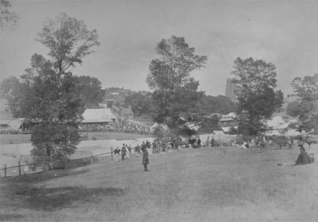
The Woodbridge Horse Show circa 1920.
Note the fencing along Seckford Street.
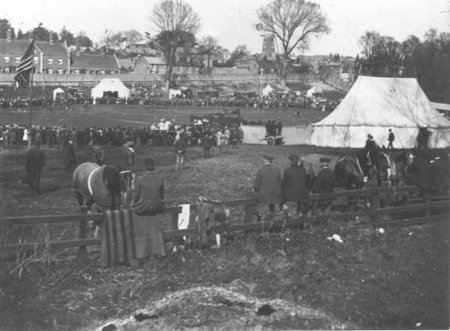
The Woodbridge Horse Show circa 1865
Scarff's market garden was established in the 1880s and the family also ran a greengrocer's shop on The Thoroughfare. They advertised that their 'fruit and vegetables were fresh from the garden'. The market garden closed in the 1960s and the whole area was redeveloped. Housing was built along the parts which abutted Seckford Street and Drybridge Hill. In addition Bridgewood Road was laid out to provide access to a housing estate. The latter was bounded on the east by Fen Meadow and on the south by the cemetery which had been established on Upper Warren Hill.

Scarff's Market Garden was opposite to the Seckford Hospital.
The earliest trade directory to provide a comprehensive account of the commercial life of the town was published in 1844. At that time there were six shops, an inn and a beer house on Seckford Street.
One of the shopkeepers was described as a butcher but no additional details were given for the other five shops. There were 19 such non-specific entries for the whole of Woodbridge and it is believed that all relate to the so called 'petty shops' - small shops which only sold the bare necessities.
The inn was the Queen's Head which closed in 1960 and became a private residence.
The beer house, in what is now 71 Seckford Street, was sometimes called the Brickmaker's Arms. The 1840 Tithe Apportionment records a brick kiln in a field behind what is now the Shell Petrol Station on the bypass. From there the brick makers could go down Collet's Walk and quench their thirst at the Brickmaker's Arms which eventually closed in 1908.
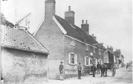
The Queen's Head Inn
Between 1844 and 1937 the number and type of commercial ventures along Seckford Street and Drybridge Hill were as shown by the table on the right. Greater detail can be found by following the links at the end of this document
There was little change in the number of shops during the nineteenth century but between 1892 and 1937 their number fell from 6 to 2. Today there are none.
A third public house, The Seckford Arms had opened by 1874. When it closed in 2010 it was the last of the public houses on Seckford Street and Drybridge Hill.
Number and type of the commercial ventures on Seckford Street
| 1844 | 1874 | 1892 | 1937 | ||
| Shop | 6 | 5 | 6 | 2 | |
| Artisan | 11 | 5 | 7 | ||
| Merchant | 1 | ||||
| Office | 1 | ||||
| Public House | 2 | 3 | 3 | 2 | |
| Market Garden | 1 | 2 | 1 | ||
| Academy | 3 | 1 | |||
| Totals | 22 | 17 | 18 | 5 |
Last Edited 2 Sept 23