Church Street & Turn Lane
The Layout of Churchgate Street and Church Lane in 1560
In 1560 a documented called an Extent of the manor of Woodbridge late Priory was produced to record of the manor’s holdings and the revenues from these holdings. What is now Church Street, was Churchgate Street, and, what is now Turn Lane, was Church Lane. Cumberland Street was Le Throughfare until sometime before 1827.
There are also two references to “Stubbes Lane otherwise Churchlane” in the Extent. The name Stubbe may be associated with Thomas Stubbe, one of the Cannons of the Priory, who is mentioned in a will dated 1444.
The coloured dots on the map to the right indicate the dwellings listed in the Extent. There were 19 along Churchgate Street and most of them were of high status. There were 3 capital messuages (large houses), 16 messuages (houses with outbuildings and a yard) and only one cottage. The only dwellings along Church Lane were four cottages. These were described thus "The inhabitants of the town of Woodbridge hold four free cottages called Le Alms Houses".
The three dwellings which abutted the former garden of the Priory each held parcels of land and of the former pond yard.
Much of the land to the east of Le Church lane was the garden of the former Guyld Hall. Between this land and the dwellings on the north side of the le Throughfare there was land and dwellings belonging to the manor of Woodbridge Ufford. Access to these dwellings may have been via what is now Bakers Lane.
The Extent mentions a cross that once stood on the northwest side of the junction of Church Street and the Throughfare. Many such crosses were pulled down after the Reformation.
A capital messuage at the top of Church Street is listed as being formerly occupied by the Prior’s farmer. He would have paid various tenants of the manor to work on the demesne land (or demesne farm) which covered some 221 acres. Most of the farm was organised into 7 fields and 11 enclosures. By 1560 this land had been rented out to nine people.

Map showing the approximate locations of the buildings mentioned in the 1560 Extent. The road layout is based on the 1881 OS map.
William Pytman is recorded as holding "one free messuage with one part of one free garden to the same adjoining, late called Le Guyld hall.” This dwelling was on Church Street, one building below the Entrance to Turn Lane. It was about where St Mary's Rectory now stands. Guild Halls like the monasteries were swept away by the Reformation. Vincent Redstone, an eminent historian, believes that the Guild Hall mentioned in the Extent was for Guild of St Loy which rendered assistance to the poor and needy during the bitter days of winter.
Changes to Churchgate Street from 1560 to 1840
In 1564 Thomas Seckford purchased the manor of Woodbridge late Priory from Elizabeth I and built his third house, which he named The Abbey, on the site of the former Priory. To gain access to The Abbey an entrance way was created at the top of Le Churchgate Street. The entrance to the former Priory had been along a lane which lead from Fen Meadow. Between the entrance to The Abbey and the gate to the Church and the cemetery there was a hedge.
In 1606 Churchgate Street was the first road in Woodbridge paved with cobble stones and by 1662 it was being called Stone Street. From the mid-19th century it was called Church Street.
By 1640 there were stage coaches connecting Woodbridge to other towns and the Bull Hotel, at the top of Church Street, was an important Coaching Inn.
The Poor Rate returns are the first detailed record of the families living in various streets in Woodbridge. During the period 1748 to 1830 the number of families in the town increased by 284%. Yet the number of people living on Church Street hardly changed. It would thus appear that by 1748 there were no spaces left between the houses that lined the street.
The Poor rate returns for 1748 and 1807 indicate that Church Street was a wealthy area - none of the families living on the street were in receipt of poor relief. As in 1560 it was a high status area.
In 1794 Alexanders Bank was established in Church Street. The Alexanders were a Quaker family who founded a bank in Needham Market in 1774. It was one of the first private banks to be established in England and it still continues as part of Barclays Bank.
In 1824 the local artist James Rowe produced the painting on the right. It is a view of Cumberland Street from Cross Corner. It shows part of a butcher's shop at the bottom of Church Street. The 1560 Extent mentions a shop in exactly the same position. Sadly Rowe did not paint any more streetscapes of Woodbridge.
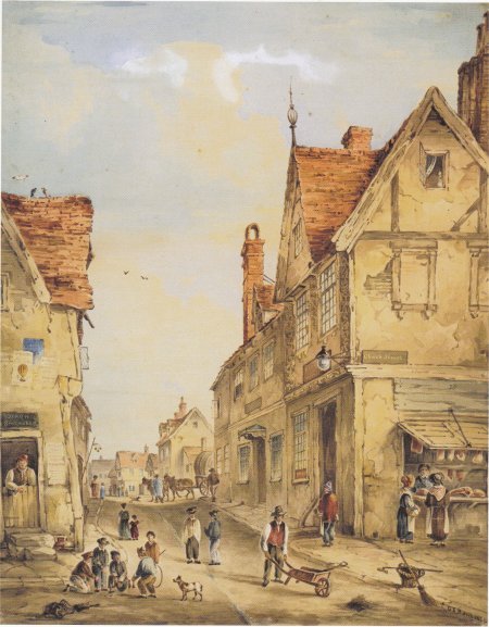
James Rowe's 1824 painting of Cumberland Street from Cross Corner.
Changes on Church Lane from 1560 to 1840
In 1601 two houses in Church Lane were given, by William Smith, to the town for use by the Poor. It seems likely that these houses had been built on what is described in the 1560 Extent as the "parcel of free garden called Le Guylde Hall".
In 1608 the Church Wardens' Accounts record that William Pitman “released his rights to a house in the town, late W Smith’s, to the use of the town of Woodbridge’. The proceeds of the rights was valued at £2 and it seems likely that this money was used to sustain the “four free cottages formerly called Le Alms House” mentioned in the 1560 Extent.
In 1678 the Friends' Meeting House was built half way down Church Lane, only 150 yards away from the Parish Church. It was described as "a spacious Meeting-house nigh (near) the church in your town, lately built and erected for that purpose". This was some 6 years after Charles II, without consulting Parliament, had proclaimed an Indulgence which enabled dissenting preachers and preaching places to be licensed. By then Parliament was incensed with Charles for exercising his prerogative and persecution of dissenting groups, such as the Quakers, was on the rise again. In December 1678 the Justices of the Peace issued an order to the Constables of Woodbridge complaining of “this Meeting House newly built near the Church". Should there attempt to meet at it "five persons or more, of the age of sixteen and upward, subjects of this realm over and besides those of the same house hold, where there is a family inhabiting at such time of their Meeting" the Constables were to “charge and command them peaceably to disperse and depart forthwith to their several homes and abodes, and not break His Majesty's peace by meeting in such an unlawful manner.”
The Quakers were not able to worship in the way they wanted until the Toleration Act was passed in 1689. Unfortunately this much welcomed change did not swell the numbers of Quakers in Woodbridge or nationally. Between 1680 and 1800, the numbers of Quakers in Woodbridge fell by a half, with a further reduction of one third by 1860.
In 1749 Thomas Wood created a nursery on land which had once been part of Le Ponde Yarde and of the garden of Woodbridge Priory.
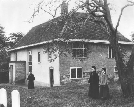
The Quaker Meeting House and cemetery on Church Lane.
Le Church lane had become Turn Lane by 1765. George Arnott notes that premises at the corner of the lane were described in 1736 as "situate in ye Stone Street near ye Turn" and by inference suggests that this was the source of the later name.
In 1791 the manor of Woodbridge late Priory, along with the Sessions House was sold to the banker Phillips Richards. At the same time the Abbey and its grounds were sold to Francis Brook of Ufford who, twenty one years later, sold it and Barrack Farm to William Carthew. When he died 1827 the Abbey and its grounds were bequeathed to Morden Carthew.
An extract from the 1838 Tithe Map is shown on the right. The red and the orange lines have been added to show Church Street and Turn Lane respectively. Part of the map, which is held by the Suffolk Record Office is damaged, but all the key feature are present. Each plot of land is numbered and a separate Tithe Apportionment gives full details of the landowners, occupiers, land use and plot size.
In 1560 there were 11 and 8 buildings along the eastern and western side of Church Street respectively. By 1840 the number of buildings had increased from 14 to 16 and there was no space for any more.
There were large gardens between Church Street and Turn Lane (numbers 466, 465, 463 and 461 on the Tithe Map) and a large nursery at the bottom of Turn Lane (224). It is on these plots of land that future building would occur.
A survey was conducted by the Woodbridge Society in 2004 to identify buildings which were known to be timber framed and those which have some external features which suggest they might be timber framed. Along the eastern side of Church Street there were 4 buildings which were timber framed and 2 which might have been timber framed. On the western side these were 5 buildings which were timber framed and 6 which might have been timber framed.
Extract from the 1838 Tithe Map. The red and
orange lines have been added to show Church
Street and Turn Lane respectively

Church Street from 1840 to the present
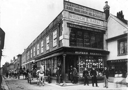
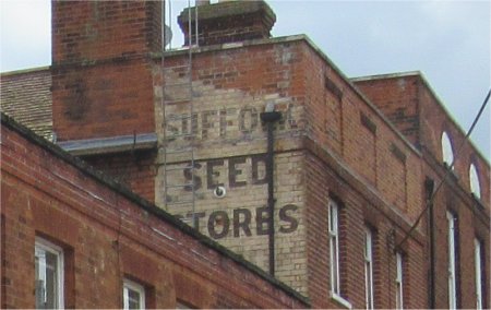
In 1871 Wrinch and Barnes established a thriving concern on Cross Corner. The entrance was on Church Street but most of the frontage was on Cumberland Street. They described themselves "wholesale and furnishing iron mongers, bar iron and nail steel merchants." By 1892 they had also become agents for "washing, wringing, mangling and other machinery" and had a stores and warehouses adjoining the railway station. Sometime in the 1890s the Cross Corner premises was taken over by Fred Smith whose business eventually became Suffolk Seed Stores. The building burnt down in 1917. Only part of the two storey building was re-constructed. The remainder, running along Cumberland Street, was replaced by a line of single storey shops. These new buildings were narrower than the original and the entrance to Cumberland Street was thus widened.
Wrinch and Barnes Department Store at Cross Corner.
The shop closed in 1904 and was taken over by the
Suffolk Seed Store but the building was destroyed by
fire in 1917. Prezzo's now occupy part of the site
After their shop was burnt down Fred Smith moved Suffolk Seed Stores across Church Street to the building next to Barclay's Bank. It had formerly been the premises of Edward Easton, a family chemist. It had an arched doorway and arched windows. A photograph of the building is shown below.
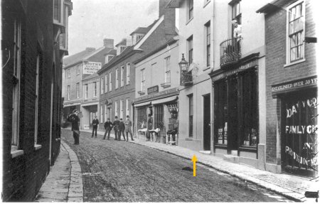
Fred Smith eventually acquired the two adjoining buildings which had been used by Davy Crowe, a family grocer and provision merchant. A photograph showing the end building, and part of the building in the middle, is shown on the right..
Fred Smith cut an archway through part of the ground floor of the end building to provide an entrance to a court yard which became known as Stone Place. Fred Smith also converted the ground floor of the three buildings into a shop and he may have used all or part of it for Suffolk Seed Store. The upper floors of both of the buildings were rented out as offices with entrances from Stone Place.
Suffolk Seeds closed their stores in 1992 but they retained the upper floors for their Head Office until they moved to Framlingham. The gable end of their building in Church Street still bears the sign Suffolk Seed Stores.

Suffolk Seeds' moved into this building on Church Street. The man standing in the doorway is probably Fred Smith.
The two adjoining buildings on Church Street were acquired by
Fred Smith. The orange arrow marks the centre of the
archway he put into the building.
In September 1921 eleven sisters and the Carmelite Order came from the order’s U.K. headquarters in Notting Hill, London, to establish a convent in Stone House, Church Street. The house was a gift from Father Cooper, a retired Roman Catholic priest. (Stone House had previously been owned by Dr Hubert Airy, son of the Astronomer Royal.) The community grew rapidly and in 1925 they bought properties in Church Street on either side of Stone House.
One of the sisters, Margaret Agnes Rope, had been a stained glass artist of considerable repute in the Arts and Crafts movement before she entered the convent in 1923. A studio was made for her in the convent grounds, where she was able to continue with her work. After working on the glass she sent it to a factory in Fulham, London, where it was fired and returned to her for finishing. She made many fine windows, and her work provided the main source of income for the convent. The nuns also made vestments.
The nuns had a rigorous regime of worship, prayer and work. Only two of them were allowed to venture into the outside world, but there was a parlour where visitors, who came to ask for advice or for a prayer to be said, could talk to the nuns through a grill.
Messages and goods for the convent were put into a ‘turn’, a revolving cylinder fixed into the wall. The cylinder was then rotated so that its contents could be taken out inside the convent. Some say that this is where the name Turn Lane comes from but they are wrong. The name Turn Lane dates back to at least 1765.
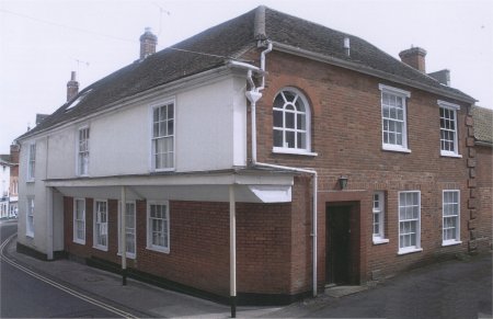
This building on the corner of Church Street and Turn Lane, which used to be a shop, was purchased to expand the Carmelite Convent.
There is an account in the Woodbridge Reporter of January 18th 1934, of the disturbances at a lecture, organised by an extremist Protestant sect, which was critical of the life of the Carmelite Nuns.
By 1938 the premises in Church Street had become too cramped and noisy for the nuns, and they moved to Rushmere. Then, in 1948, they moved to Quidenham near Attleborough in Norfolk, where the community remains.
After the nuns left a carriage arch was put through the part of the middle building which had formed the convent. The Church Street buildings were used by the military during the war and afterwards they were sold to the Culmark brush company who built a large factory with access on Turn Lane. The upper part of what had been the Carmelite Convent was split off by a dividing wall.
Culmark ceased trading in 1975 and in 1982 a residential development, Carmelite Place, was built on the site. The northern part of the frontage on Church Street was hardly changed. The old Culmark factory was used for the printing works of Antique Collectors Club who also had the Art Bookshop on Church Street.
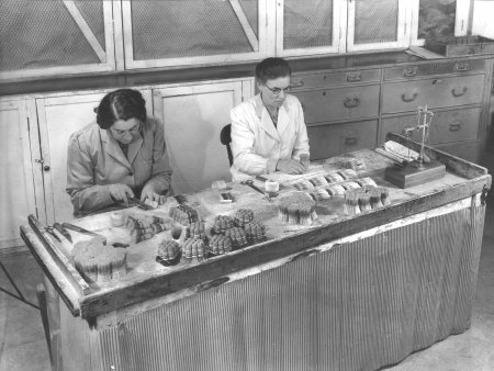
One of the stages of assembling
Culmark's shaving brushes.
.
The map on the right shows all the changes which have occurred to the west of Church Street since 1960. None of the buildings shaded grey have changed since 1960.
In 1983/84 the three buildings which had formed the Carmelite Convent and its garden were used to create Carmelite Court which had 10 residential units. The four houses shaded yellow on the map were built on what had been the garden of the Convent and six dwellings were created in the three original buildings. One of these six dwellings was used for a new rectory for the vicar of St Mary's. Each dwelling within Carmelite Place had a reserved parking space and there was a high wall, shown as an orange line, around the whole complex.
Number 9 Church Street had a rear entrance and car park within Carmelite Court and a front door on Church Street. After the building was refurbished it replaced the previous Rectory at 100, Seckford Street.
By about 2000 the Antique Collectors Club had moved from Woodbridge and the old Culmark factory was not used. The latter was demolished in about 2010 and the site was used for five new houses. Three of the houses were accessed by Bakers Lane. The two others were reached via the upper part of Turn Lane. These five houses are shaded light blue on the map.
Since 1844 the Thoroughfare has been the only street not to experience a decrease in the number of shops and businesses along it. The decline in commercial activity on Church Street was less than for any other street and it replaced New Street as the second most important commercial street in the town.

The coloured blocks on this map show the buildings which
were erected either side of Turn Lane post 1960.
Wood's Nursery was bought by Notcutts in 1897 who continued to use the nursery on the Abbey grounds until 1981.
Between 1920 and 1926 the two houses, which had been given to the town in 1601 for use by the Poor, were demolished. Most of the site has since been incorporated into the grounds of the Abbey School. All that remains is a triangular parking space on Turn lane.
In the 1960s a bungalow was built, opposite the parking space. The bungalow, which is shaded pink on the map above, was on the lower part of the yard of one of the houses on Cumberland Street.
By 1935 there were only two Quakers living in the town and it was decided to put the Meeting House on the market. In 1937 it was purchased by Colonel Carthew, the then owner of the Abbey, who was buying any property which overlooked his house and land. During his short ownership the building was used for St Mary's Lads' Club. After Colonel Carthew died his widow sold the former Meeting House, in 1949, to Mr A H Rushbrook who used it to store china and glass for his shop on Church Street. Mr Rushbrook also had permission to grow vegetables on the burial ground provided they were more than 8 ft from the grave stones. After Mr Rushbrook died his son sold the Meeting House, in 1971, to a property developer who disposed of its fittings and had plans drawn up to convert it into a private house. This work was completed sometime after 1973.
From 1890 the Abbey was occupied by Colonel Ranulphus John Carthew JP. When he died in 1943 his widow sold The Abbey and its 14 acres of land to the Woodbridge Endowed School. Six years later The Abbey opened as a Junior School.
In 1981 Notcutts decided that they no longer needed the nursery on the Abbey grounds. This made it possible to expand the Abbey Junior School in the 1990s. Two new buildings and a car park were erected on part of the site of the former nursery. The entrance to the car park was via a gate at the bottom of Turn Lane. The new buildings are shaded light green on the map above and the car park is shaded light brown.
In 1996 the burial ground was leased to the Town Council. By 2003 there were concerns about the state of the boundary wall so the Friends of the Quaker Burial Ground were established to raise funds to repair the wall and to raise awareness of the site. The repair work was funded by the Heritage Lottery Fund and was completed in 2005.
Last edited 2 Sept 23