Quay Street & Crown Place
Quay Street in 1560
The earliest comprehensive description of Woodbridge is to be found in the 1560 Extent of the manor of Woodbridge late Priory. It is from this document, which is written in Latin, that the map on the right has been derived. The road layout is based on the 1881 OS map. Where translations from the Latin are quoted they are written in italics.
What we now call Quay Street was variously referred to in the Extent as either the Le Myll Waye leading from the market place towards the lord's water mill or as Thasea (to the sea).
At the bottom of Quay Street there was a junction with the Old Kings High way. The exact route of this highway cannot be determined accurately but it appears to have roughly followed what is now Station Road, Quayside and Lime Kiln Quay Road.
Beyond the junction with Le Mell Lane, the Old Kings High way ran alongside an extensive marsh into which flowed the Navern Brooke. This marsh abutted a causeway leading to the lord’s water mill (the tide mill).
During the period between the Norman Conquest and 1560, river walls were built along parts of the lower reaches of the estuary to turn the salt marsh, which lined much of the estuary, into arable land. Construction of river walls higher up the estuary proceeded at a later date.
Without a river wall the riverside area at Woodbridge would be liable to flooding, which is no doubt why most of the land below Le Throughfare was used for agriculture.
At the northern end of Le Myll Waye there were three dwellings and three commercial buildings. At the southern end there were two commercial buildings. The commercial buildings are numbered 1 to 5 on the map to the right.
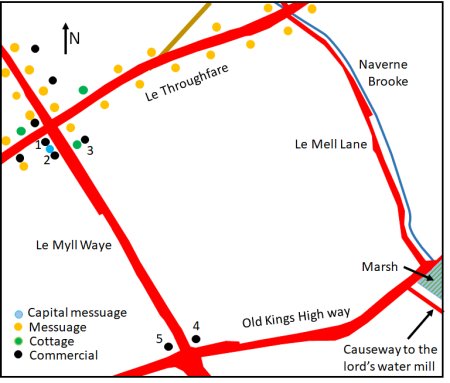
Map showing the approximate locations of the buildings mentioned in the 1560 Extent. Road layout based on that on the 1881 OS map.
Number 1 was a capital messuage lately built on with a shop hall and a chamber. Number 2 was a barn with other small building. Number 3 was a cottage built on with a kitchen, bake house, stables and a barn. Number 4 was a stone building, roofed with tiles, called a warehouse. Number 5 was one building called a warehouse.
On the other side of the Old Kings Highway there were two Keyes (quays) which are not shown on the map. On Bele’s Keye there was a single warehouse and on Stubb's Keye there were two warehouses.
According to George Arnott, an eminent local historian, an entry in the 1589 Court Rolls of the manor mentions Key Lane. Sometime later Key Lane became Quay Lane. By 1881 it was being called Quay Street.
By 1827 all that remained of the Old Kings Highway ran from the bottom of Quay Street to the lane alongside the Naverne Brook. The name which has most often be given to this section of road is Quayside. Beyond the Naverne Brook all that remained of the Old Kings Highway was a footpath that ran alongside marsh land.
To avoid confusion names Quay Street and Quayside will be used throughout the rest of this article.
The Crown Hotel, on the eastern side of the junction with the Thoroughfare, was a 17th century coaching Inn. Between the Quay Congregational Church and the Crown Hotel there was a bowling green and a drift way leading to Crown Meadow, a large field which ran down to Quayside. Crown Meadow would have been used to provide pasture and respite for the horses that pulled the coaches which arrived at the Inn.
Crown Meadow was also called Lady Field because it where the Lady Day Fair was held. It was also used for town celebrations such as that which followed the end of the Napoleonic war. In 1814 the Ipswich Journal reported that 'The ringing of bells, the soul cheering music of the fife and drums and the deep thunder of artillery greeted the arrival of the morning. All was noise, and glee, and jollity; and, that the amusements of the day might not be distracted by the dull occupation of business, the shops were closed at 12 o'clock'. The celebrations finished with a dinner for the poor and games on Crown Meadow."
Below the Crown Hotel was the Quay Congregational Church. This church was formed in July 1651 by the Rev Woodhall, together with fifty-five “brethren and sisters”. In 1689, John Bass, purchased the piece of ground on which the present Woodbridge Quay Church now stands. The first Church to be erected on the site could seat 500.
The northern side of the church abutted the entrance to Crown Meadow. On the southern side there was a house and then a house with a large garden which ran down to Studd's Quay Counting House. The latter abutted the Ship Inn on Quayside.
On the western side of Quay Street there was a large building which abutted both Quay Street and Cumberland Street. The entrance to the building, which appears to have been a house, was on Cumberland Street. The grounds of this building went half way down Quay Street and there was a building in these grounds near to what is now the The Table, a sea food restaurant. There was then a gap before reaching the Customs House.
In 1569, Robert Nottingham, Surveyor of Customs, had established Woodbridge’s first Custom House in rented property on one of the quays. According to the 1661 will of Thomas Redgrave an "iron house" on one of the quay was used as a Customs House. Sometime in the eighteenth century the Customs House was moved in to building on Quay Street which was opposite the Congregational Church.
Below the Customs House there was a yard and then a terrace of 5 dwellings which abutted the Anchor Inn at the bottom of Quay Street.
The earliest detailed map of Woodbridge was produced by Isaac Johnson in 1827 and the part showing Quay Lane can be seen on the right. This map clearly shows that development along the western side of Quay Lane had been constrained by a mansion and gardens which ran all the way from Cumberland Street to what is now Station Road and that, on the eastern side of the lane, a significant part of the Crown premises was laid out with gardens.
None of theses features had changed by the time the 1840 Tithe Map and its apportionment was produced. An extract from the tithe map, showing Quay Lane and the surrounding area, can be found in the final section of this Area History as can be the relevant parts of the Tithe Apportionment.
The basic features on the Tithe Map are the same as on Isaac Johnson's Map. The latter is reproduced here because it shows the gardens in greater detail.
Loading and unloading the vessels at the quays at the bottom of Quay Street was a laborious process. To quench the thirst that this effort created there were three Inns near the quays - the Ship, the Boat and the Anchor. The Anchor Inn, and Ship were either side of the bottom of Quay Street. While the Boat was by the causeway leading to the Tide Mill and the ferry. Both the Boat and the Ship are now private residences.
That part of the Ship Inn which abutted Quay Street was built of stone and it is thus likely to be the stone building, roofed with tiles, called a warehouse recorded in the 1560 Extent. A large part of the Anchor Inn on the other side of Quay Street is timber framed and it is thus likely to incorporate the building called a warehouse in 1560.
The Poor Rate Returns for 1748 to 1830 do not provide any detailed data for Quay Street because all the entries for Quays and Lanes were aggregated into a single entry.
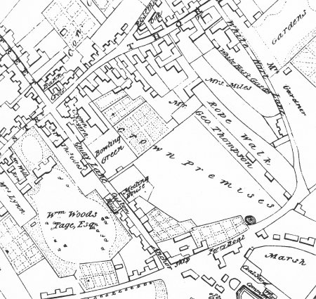
Extract, from Isaac Johnson's 1827 map of Woodbridge, showing Quay Lane and the surrounding area.
As early as 1871 there were negative comments about Quay Street. A newspaper article in 1871 stated that "the entrance to Woodbridge from the station is perhaps the most deplorable in the country”. If the intention of the article was to stimulate improvements in the appearance of Quay Street it failed.
The Western Side of Quay Street
In 1874 the Woodbridge Post Office was established in part of the building on the corner Quay Street and Cumberland Street. By 1925 the adjoining property was being used A.J.Garnham, Jobmaster and Funeral Carriage Proprietor. The entrances to both buildings were on Cumberland Street.
By 1934 the Post Office required more space so it was moved to a new building further up Cumberland Street. A.J.Garnham continued to use the adjoining building. For some time the ground floor of the former Post Office was used as a hat shop. Both the former Post Office, and what remained of A.J.Garnham's property, were demolished in the 1960's.
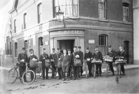
Earliest photograph of the Post Office staff outside the Post Office.
The former Post Office and Garnham's property prior
to their demolition in the 1960s.
A comparison of the 1840 Tithe Map and the 1881 Ordinance Survey maps shows that the layout of the buildings on Quay Street, which were below the Post Office, had changed significantly. The part of the Post Office that ran along side Quay Street had been reduced in length in order to create a yard for R H Rowland and Sons Ltd. Their main outlet was on the Throughfare.
By 1881 two new buildings had been erected between this yard and the house which is now the Captain's Table. Both of the new buildings ran alongside Quay Street and they had yards at the rear. The only photograph showing part of these buildings, and the yard below the Post Office, is shown on the right.
In 1888 Ingram Smith moved his carpentry, joinery and undertaking business into what is now 3 Quay Street (The Captain's Table) and the two adjoining buildings.
By 1927 the firm had become a general builder.
In 1949 number 3 Quay Street became the office of Ingram Smith's expanding company and he purchased what remained of two of the maltings in Crown Place in order to expand his joinery shop.
In 1971 he moved his office to the Crown Place maltings and sold his properties on Quay Street.
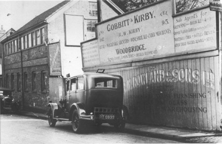
This photograph shows the yard and one of the new buildings below the Post Office. The roof line of second new building can just be seen on the left of the photograph.
The line of three closely space buildings remained intact until 1983. At that time the building in the centre was demolished and its was replaced by Sutton House, a three storey red brick building. There were two apartments and each had half of the second and third floor. Both apartments had a parking space on the ground floor.
In 1983 Sutton House was built between 3 Quay Street (now The Captain's
Table) and the building at then
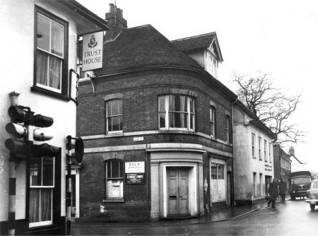
Number 5 Quay Street, what used to be the Customs House, is in the centre of the picture on the right. It is set back from the road and has the potential to be an more imposing building. On the 31st March 1882 Woodbridge ceased to be a port for the purposes of the Customs Consolidated Act 1876. Thereafter, Woodbridge came under the jurisdiction of Ipswich and its Registry was withdrawn. The former Customs House then became a private residence.
Number 7 Quay Street, abuts the southern side of the former Customs House. Most of the building is post 1840 but the part of it which abuts the former Customs House is timber framed. Thus it is possible that Number 7 incorporates some part of the Old Customs house.
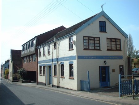
According to the trade directories, Number 7 has variously been used as a confectionery shop and as a tea room. It is currently The Woodbridge Antiques Centre.
Between number 7 and the Anchor Inn there is an attractive terrace of two and three-storey buildings. They appear to be the same as they were in 1840.
Below the terrace is the Anchor Inn which has entrances on Quay Street and Quayside.
The Old Customs House is in the centre of this photograph.
To the left of it the Woodbridge Antiques Centre
Both the former Post Office and Garnham's Garage were demolished in the 1960s and work soon started to replace them by two angular redbrick buildings which, over the years, has attracted many derogatory comments.
One of the buildings had two commercial units on the ground floor and the entrances to both were on Cumberland Street. On the upper floor there were flats which had an entrance on a rear courtyard off Quay Street. This courtyard also had restricted car parking spaces. It has not been possible to determine how the occupancy of the commercial units has changed but since 2006 they were used by the National Westminster Bank and an oriental restaurant. Since 2018 considerable work has been done to create a Blue Salt restaurant on the ground floor and to increase the number of residential units by increasing the height of the building.
The second building was another angular red brick building erected in the 1960s. Until 2004 it was a tyre and exhaust centre. This closed in 2004 and then two shops were created in the premises. Trading ceased in 2019 and the future of the building remains uncertain. The 1987 Town Centre Local Plan observed that "the building contributes little in the way or architectural style and quality" and that "the demolition of this building and the redevelopment of the site for residential units (flats) of a high quality design would be favourably received. Alternatively, the conversion of the building into a commercial use (shops or offices) would be acceptable, particularly where the treatment resulted in a visual improvement to the townscape of Quay Street".
At last, in 2020, planning consent was granted for the demolition of the existing building and the erection of a three storey building comprising four two bedroom flats and one single bedroom flat and associated vehicular access and parking. But, as yet, nothing has been done to the building.
View down Quay Street in the early 1970's. The two red brick buildings occupied the site which had previous been the Post Office and Garnham's garage.
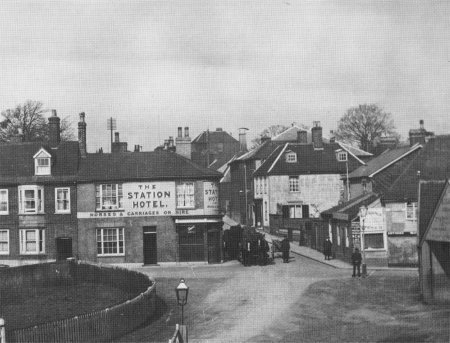
The opening of the Ipswich, Woodbridge, Lowestoft railway in 1859 would have heralded a decline in the number of coaches using the Crown Tavern and within 10 years applications to renew licences to operate a turnpike had to be examined by the Turnpike Trust Commission. If a licence were renewed it was on condition that all existing debts should be discharged as soon as possible and the road then handed over to a Highway District. Given this background the owner of the Crown Tavern would have soon realized that the pasture used to refresh the coaching horses would soon not be needed and could be put to better use.
The 1881 Ordnance Survey map gives clear evidence that such a changes had occurred. The north-eastern wing of the Crown Hotel had been demolished and a bank was built on the site.
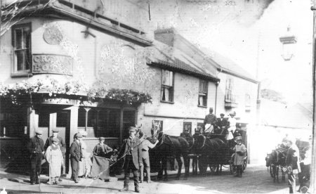
This picture of the Crown Hotel was taken towards the end of coaching era. The man in the centre of the photograph was Poll Reynolds, a self appointed traffic warden. He died in 1910 aged 32 and is buried in the old Woodbridge Cemetery.
By 1881 the Crown Hotel's bowling green had been reduced in size to allow a building, which appears to be a maltings, to be built along side Quay Street. The walls on the ground floor were brick and they supported a timber upper storey. The southern end of the building has the characteristics of a heating stack used in maltings. The windows on the ground floor are a later addition and indicate a change of use.
Some time before 1937 the maltings was converted into an annex, called the Assembly Rooms, of the Crown Hotel. An entry in a Trade Directory for that year states that adjoining the Crown Hotel there was "a large assembly hall accommodating 300, with a dance floor; the hall is also used for meetings, shows, etc." The Assembly Rooms have been derelict since the 1970s but they are still part of the hotel complex.
By 1977 the land which used to be the Crown Hotel's bowling green was used to create motel style accommodation and parking. In 2020 planning permission was sought to transform this part of the hotel and the derelict Assembly Rooms. The objective is to demolish the motel style accommodation and replaced it by a new block containing flats and a Mews House, and to convert the former Assembly Rooms into town houses and apartments. A decision on this planning application is expected by the end of September 2020.
The Crown Meadows had also been transformed by 1881. Roads had been laid out to create to Crown Place, a mixture of residential and commercial developments. There was access to it via Quay Street and Quayside. A full description of Crown Place is given in the next section.
The Assembly rooms have changed since this photograph
was taken in the 1990s.
By the time the 1881 OS map had been produced an extension had been added to the southern end of Quay Street Congregational Church. Part of it was a porch which provide direct access to the church from Quay Street. Behind the church there was a strip of land, which had been part of Crown Meadows, which had been procured to extend the church's burial ground.
In 1896 the Quay Street Congregational Church was renovated, new seats were installed along with a new pulpit, new system of ventilation and gas lighting. The organ was also overhauled and cleaned.
During the 1980s the burial ground had been reduced by half. Part of it had been converted to a car park and the rest was sold to a builder who used it for a yard before erecting two houses on the site.
The biggest change to the church occurred in 2006 when it was reunited with a group which, in 1787, had left to worship at the house of Jonathan Beaumont. In 1810 he built the Beaumont Baptist Church in Cuttings Lane (now Chapel Street). The worship was congregational and the chapel had strong links with the Quay Street Church until 1904 when it became a strict Baptist Chapel. In 2006 the Beaumont Baptist Chapel was reunited with the Congregational Church and the Chapel Street building was converted to a private residence. The combined church is a member of the Baptist Union and is known as Woodbridge Quay Church. A total refurbishment and extension of the building started in October 2012 and was completed in September 2013.
Woodbridge Quay Church in 2020
Adjoining the southern side of the church there were two houses, 4 and 6 Quay Street, which were both built before 1840. During the 1980s part of the ground floor of 6 Quay Street was used to create The Royal Bengal Restaurant.
Number 6 Quay Street had a large garden and, by 1881, part of it had been used for a two semi detached houses which were set back from Quay Street. These houses can be clearly in the photograph on the right. What was left of a wedge shaped garden was used to was create a narrow access way leading to a commercial business the rear. Below this entrance there is a single storey extension, with a sloping roof, which runs down to a single storey building which abuts Quay Street and Quayside. In 1840 this building was Studd's Quay Counting House.
By 1950 the single story building had been extended up to the access way. By 2020 the building had be painted light blue and it clearly stands out in the photograph below. Over the last 20 years the building had been used for a number of commercials ventures. The latest is Quay Street Cooperative, a hairdressers.
Photograph of the southern end of Quay Street circa 1900.
Photograph of the southern
end of Quay Street in 2000.
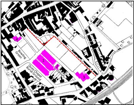
Between the publication of the 1840 Tithe Map and the 1881 Ordnance Survey Map, a private road, Crown Place, had been laid out to provide access to what used to be Crown Meadows. By 1881 these buildings had been erected:-
1.....A group of three maltings.
2.....Roman Catholic Church built in 1972
3.....A three storey steam mill having a large chimney.
4.....St Anne's School.
These buildings are all shown in purple on the map to the right. Below the group of three maltings and the church there is a cluster of thirteen houses.
The dashed red line on the map marks the north-eastern boundary of what used to be Crown Meadows. Beyond it is Doric Place.
Extract from the 1881 OS map showing the development
on what used to be the Crown Meadows. The dwellings
shaded red had been built by 1950
The steam mill on Quayside operated until about 1928 after which it became a door factory. In 1953 Nunn's Corn and Coal bought the building which was eventually destroyed by fire in 1963. The photograph on the right was taken the day after the fire.
The remains of the former mill, and of two adjacent cottages, were soon demolished and a new mill was built on the site. Nunn's operated this mill until 1990. For a while the building was used as a temporary store and was then left to deteriorate.
The Roman Catholic Church became a private residence in 1929 after the diocese purchased the former Public Lecture Hall on St John's Street and converted it into St Thomas of Canterbury Roman Catholic Church.
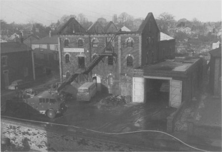
Nunn's Corn and Coal the day after the building
was destroyed by fire in 1963
The map on the right shows the buildings on Crown Place in 1976.
By 1950 six semidetached houses had been built on the north western side of Crown Place and their rear gardens abutted the boundary of Crown Meadows.
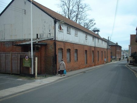
By 1967 the maltings were no longer being used. The heating sections had been demolished and what remained of the buildings were being put to other uses. By 1971 two of them were being used by Ingram Smith for his joinery shop. The third one had become a grain store as had Nunn's Mill at the entrance to Crown Place. A house had also been built alongside the access way to the houses below the Thoroughfare.
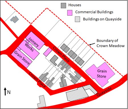
The buildings on Crown Place by 1976.
The map on the right shows the buildings on Crown Place in 2011. By then what remained of the three maltings were subdivided into three-storey apartments. To the south east of the apartments there are garages and space for parking.
Since 1976 the house marked Number 1 had been expanded and the two houses marked Number 2 had been erected on what used to be a builder's yard. This yard had previously been part of the burial ground of the Quay Street Congregational Church.
The first planning application to demolish Nunn's Mill, and to replace it by 14 flats, was made in March 2002. The application was rejected by Suffolk Coastal District Council as was the subsequent appeal.
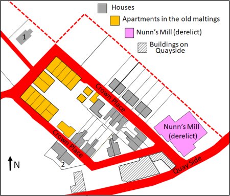
Crown Place by 2011
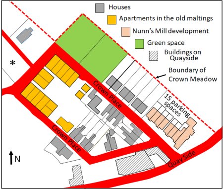
In August 2013 FW properties were granted planning permission to redevelop the Nunn's Mill site and Whisstocks boat yard. The sites were cleared by September 2015. Work on the Nunn's Mile site was completed in the spring of 2017 and the Whisstocks development was finished by the autumn of that year.
In 2018 there were planning applications to build houses on the two plots shaded green on the map to the right. The applications were rejected and the two plots were designated as essential green spaces. The land has since been sold to residents of Doric Place to use as gardens.
In 2015 a house was being built on the plot of land marked with an asterisk and five years later the house was enlarged. The land on which the house was built had previously been part of the garden of St Anne's School.
Crown Place remains a private road.
Crown Place in 2017
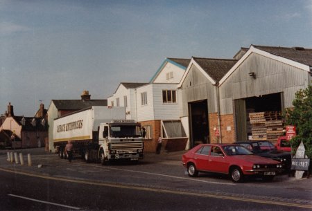
Nunn's Mill circa 1990. By then it was being used as a pallet store
and the building was allowed to deteriorate.
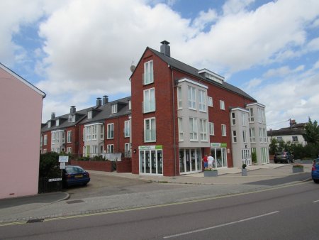
Nunn's Mill Apartments and Townhouses. The ground floor of the apartment block is reserved for offices and shops.
Last edited 2 Sept 23