Cumberland Street
Cumberland Street in 1560
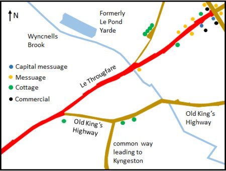
The earliest comprehensive description of the town is to be found in the 1560 Extent of the manor of Woodbridge late Priory. It is from this document, written in Latin, that the map on the right has been derived. The road layout is based on the 1881 OS map. Where translations from Latin are quoted they are in italics.
In 1560 what we now call the Thoroughfare and Cumberland Street was then Le Throughfare. It bypassed part of the King’s High way leading to Gippiswich (Ipswich). The section which was bypassed was referred to as the Old King’s High way. It followed what is now Station Road, Quayside and Lime Kiln Quay Road. Over time, the eastern end of what is now Cumberland Street was extended from the junction with Station Road to the entrance to Notcutts Garden Centre. The western end of Cumberland Street has always been at the junction with what is now Church Street and Quay Street.
By 1587 what had been called the common way leading to Kyngeston was variously called Kingston way or Spennings way. By early 1800 it was extended to link up with Cumberland Street and it is now called Kingston Road.
Within the parish boundary of Woodbridge, there were plots of land belonging to a number of manors. Such plots are only mentioned in the Extent if they abut plots of land belonging to the manor of Woodbridge late Priory. Most of the land belonging to other manors, principally the manor of Woodbridge Ufford, and the manor of Hasketon, was below the Le Throughfare but within this area there was some land of the manor of Woodbridge late Priory.
Map showing the approximate locations of the buildings mentioned in the 1560 Extent. The road layout is based on the 1881 OS map.
The coloured dots on the map above indicate the approximate location of the dwellings and commercial buildings listed in the Extent. Just below where Wynchells Brook goes under Le Thoroughfare there was messuage now one brewery. There was still a brewery on this site until the late 19th century. Prior to the Reformation there was also a cross at the eastern end of what is now Cumberland Street.
During the mid seventeenth century, shipbuilding in the Lime Kiln Quay area destroyed part of the Old King’s High way. After that the only direct route through the town was along the Lower Thoroughfare (later Cumberland Street) and the Upper Thoroughfare.
Isaac Johnson's 1827 map of Woodbridge shows that the Lower Thoroughfare had become Cumberland Street. George Arnott suggests the new name was associated with Simon Cumberland who held land in the area. It is also possible that the name was adopted during the Napoleonic war when there was a garrison on the outskirts of the town. Many of the officers and their families lived on what is now Cumberland Street and they choose to name their houses after famous military figures, one of which was the Duke of Cumberland.
In 1661 two houses, which were on the west side of the junction with what are now Cumberland Street and Kingston Road, were given to the Town, by William Bearman, "for the use of the poor". These houses, and an adjoining plot of land lying between Cumberland Street and Station Road, became part of what became known as the "Town Lands". A report of the Charity Commissioners in 1837 records that the houses "are occupied rent-free by poor persons" and that the adjoining land had been let on a 61 year lease from 1766.
Thomas Wood created a nursery in 1749 on land which had once been part of the garden of Woodbridge Priory. This land abutted what is now Turn Lane. By 1784 the nursery had been expanded by purchasing a large plot of land abutting what is now Cumberland Street. By 1840 this plot of land was expanded by purchasing the adjoining Cherry Tree Meadows. Only a small part of the meadows abutted Cumberland Street. The rest of it ran alongside Ipswich Road.
Eden Lodge, which was initially called ‘The Grove’, was built in 1818 for William Woods Page. It was on a 2-acre site set back from an old lath and plaster house fronting on Cumberland Street which was eventually demolished to improve the appearance of The Grove. An Isaac Johnson plan of 1819 shows that from Cumberland Street there was a tree lined entrance to the house which had a greenhouse on the left and the coach house and stables on the right. At the back of the house there were shrubberies, lawn and kitchen garden extending to what is now Station Road. A central bay window afforded a view of the estuary.
Around the beginning of the twentieth century The Grove was purchased Mr Reginald Eden Dixon, who renamed it ‘Eden Lodge’. He was a keen sportsman and collector of clocks.
William Woods Page D. L., J.P. once occupied Eden Lodge. He had studied at Edinburgh University and in Leyden, and was very interested in science. The house had an excellent library and a chemical laboratory to which William devoted much of his time. He is said to have applied his science to the construction of his house, to sanitary arrangements and to special stoves or fireplaces made to revolve on a pivot to face the wall when too hot.
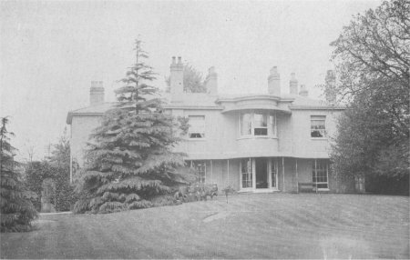
The rear view of Eden Lodge
Three other residential properties on the southern side of Cumberland Street had extensive grounds which ran down to what is now Station Road.
Alexander's brewery had an entrance on Cumberland Street but the main part of the brewery abutted Station Road.
The five properties which abutted both Cumberland St and Station Rd, took up over two thirds of the land between these two roads.
The Poor Rate returns are the first detailed record of the families living in various streets in Woodbridge. During the period 1748 to 1830 the number of families in the town increased by 284%. Yet the number of people living on The Thoroughfare and Cumberland Street only increased by 157%. This indicates that there were few spaces in Cumberland Street for new building. This was certainly the case by the time Isaac Johnson produced his map of the town in 1827.
The map below clearly shows the extent of the gardens, and of the two nursery grounds, abutting Cumberland Street.

Extract from Isaac Johnson's map of Woodbridge in 1827.
Cumberland Street slopes gently to the south-west and curves gradually throughout its length. Most of the buildings alongside Cumberland Street are of a consistently high quality. The majority are two storey and a high proportion of them have been recorded on the register of listed building. One of the notable features of the buildings is that nearly all have vertically proportioned sash windows, and the many elegant door ways and entrances create a pleasing rhythm.
The Gazetteers and Directories published since 1840 indicate that the majority of buildings on Cumberland Street were solely residential but there was also a significant number of shops, businesses and artisans working in their homes. The table on the right lists the number of businesses per street at various times between 1844 and 1985. Over this period, Cumberland Street became progressively more residential but it has managed to maintain a core of commercial activity near the junction with the Thoroughfare.
By 1985 there were still 13 shops and businesses on Cumberland Street. New Street had the same number and only the Thoroughfare, with 88, and Church Street, with 28, had more.
In 1844 most of the commercial activity was concentrated around the Cross Corner entrance to Cumberland Street. Beyond that area there were a number of commercial buildings and artisan's workshops which were well spaced out. By 2000, Notcutts Garden Centre and the Cherry Tree public house were the only commercial buildings not to be within 70 metres of Cross Corner.
The table below shows how Cumberland St has changed since 1840. The number of buildings has have not changed significantly, but the number of commercial properties has declined significantly and they have become private residences.
Table showing the changes in the number of shops and
businesses along the roads in Woodbridge since 1844.
| 1844 | 1892 | 1925 | 1937 | 1985 | |
| Thoroughfare | 85 | 85 | 93 | 88 | |
| New Street | 47 | 28 | 30 | 13 | |
| Church Street | 31 | 24 | 27 | 28 | |
| Cumberland St. | 30 | 21 | 14 | 23 | 13 |
| Market Hill | 30 | 16 | 22 | 12 | |
| Seckford Street | 20 | 12 | 6 | 1 | |
| Bredfield Street | 14 | 4 | 3 | 1 | |
| Castle Street | 12 | 5 | 6 | 1 | |
| Theatre Street | 12 | 6 | 7 | 1 | |
| Brook Street | 8 | 2 | 2 | 0 | |
| Station Road | 6 | 4 | 9 | 3 | |
| 295 | 200 | 228 | 161 |
Changes which have occurred since 1840 to the building on the northern side of Cumberland St
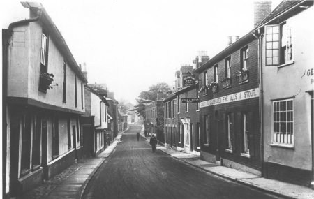
In 1824 the local artist James Rowe produced the painting on the right. It is a view of Cumberland Street from Cross Corner. It shows part of a butcher's shop at the bottom of Church Street. The 1560 Extent mentions a shop in exactly the same position. Sadly Rowe did not paint any more streetscapes of Woodbridge.
By 1871 Wrinch and Barnes had established a thriving concern on Cross Corner. They had demolished three timber framed buildings on the right hand side of the entrance to Cumberland Street and had replaced them by a two storey brick built building. The entrance was on Church Street but most of the frontage was on Cumberland Street. They described themselves as "wholesale and furnishing iron mongers, bar iron and nail steel merchants." By 1892 they had also become agents for "washing, wringing, mangling and other machinery" and had a stores and warehouses adjoining the railway station.
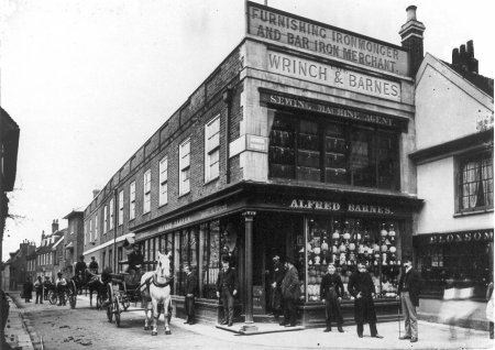
Photograph of Wrinch and Barnes' shop circa 1880
Sometime in the 1890s the Cross Corner premises was taken over by Fred Smith whose business eventually became Suffolk Seed Stores. The building burnt down in 1917 and only part of the two storey building was re-constructed. What was left was replaced by a line of single storey shops running along Cumberland Street.
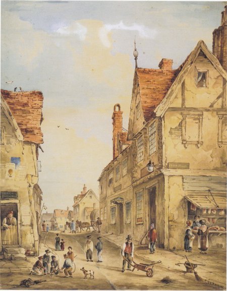
James Rowe's 1824 painting of Cumberland Street from Cross Corner.
Because the new buildings were narrower than the one it replaced it was possible to widen the pavement in front of the shops. W. Bloxsome Ltd - Gentleman's Tailor's and Outfitters were the first to occupy the corner property until they closed in 1970. It is currently a Prezzo's restaurant.
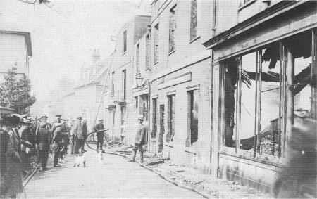
Extinguishing the Suffolk Seed Store fire in 1917
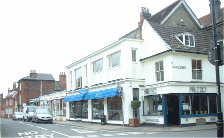
View from Cross Corner in 2019
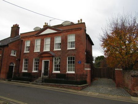
The line of single storey shops abutted a rather ugly, red brick building, which survived the fire. This building is currently a hairdressers and there is residential accommodation above. Next to it, in stark contrast, is Marston House, a splendid Georgian red-brick building. This imposing town house has fine plain tile roof with hipped dormers. On the second floor there are Victorian large pane sashes and a pleasing central first floor windows with lozenge patterned glazing bars. On the ground floor the windows have external shutters. The entrance has a notable timber door-case with a Corinthian entablature and fluted Doric pilasters. It is the most elegant door in the town.
From 1836 to 1854 Marston House was the office of the lawyer Thomas Churchyard and his two partners. One of the partners left in 1841 and Churchyard then took over Marston House thereby giving himself an office and family home under the same roof. He received several substantial inheritances from relatives which enabled him to spend time on his overwhelming passion to paint outdoors creating small oil and watercolour sketches of familiar scenes around Melton and Woodbridge. He became a master of capturing the exact time of day or the effects of changing weather. He gave some of the sketches to friends but most were stored.
He also bought, and later exchanged or sold, paintings by major artists. There is no evidence that he made money from picture dealing. It is more likely that this addiction to acquiring new painting was a drain on both his money and his time, and was thus a major contributor to his eventual financial failure.
By 1851 Churchyard had financial problems and, three years later, he was designated ‘an insolvent’. The family had to leave the splendid setting of Marston House and live for a time at Melton. By 1856 Churchyard’s financial situation appears to have improved. There are records of him buying pictures again and the family returned to Woodbridge, renting the substantial Hamblin House a hundred yards further down Cumberland Street.
In 1858 the last of Churchyard’s relatives died and he was the sole heir to what remained of his grandfather’s estate. If Churchyard was hoping for a significant inheritance he was soon disappointed. The estate was just sufficient to cover his uncle’s debts. Churchyard’s debts continued to increase and when he died on the 19th August he was bankrupt.
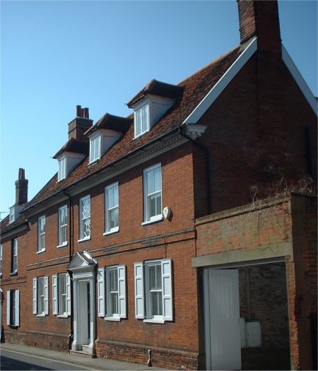
Marston House -No 6 Cumberland St. It abutted Gordon House a less impressive Georgian House.
Marston House abutted Gordon House, a less impressive Georgian residence. The left hand side of Gordon House and its drive-way can be seen in the photograph on the right.
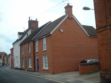
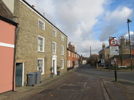
Beyond Gordon House there was No. 10 Cumberland St. This was a two storey red brick building which was the home and workshop of F Masters, a mason who made headstones and funerary monuments. A large adjoining courtyard was used to display his products until Marston moved his business to Quayside in the 1990s.
No. 12 Cumberland St was an Indian Tandoori Restaurant in 1985. It is now an elegant house.
Nos. 8, 10 and 12 Cumberland St in 2020.
No. 18 Cumberland St. was being used by the book binder Charles Fox in 1914 but, by 1925, it had reverted to being a private residence.
For many years No. 20 Cumberland St. was a Public House. In 1827 it was called the Volunteer but, by 1840 the name changed to the Wellington. The photograph on the right shows the building in 1914. The Public House had closed by 1925. The building subsequently became partly residential and partly commercial. For a time the latter was used by a yacht broker and it is currently occupied by the Bear Ink Tattoo Parlour.
No.22 Cumberland St. was a bake office in 1840 and it was still used by a baker in 1937. It is now a private residence.
On the other side of the road from these these buildings there are two timber framed houses with jetties. They are likely to be the oldest houses on Cumberland St. The nearest one is the called the Manor House. The manor referred to is that of Woodbridge Ufford which held a significant amount of land near the estuary.
Nos. 18,20 and 22 Cumberland St. are on the right of this photograph which was taken in 1914.
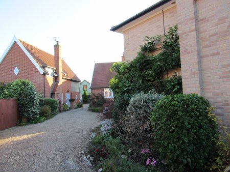
In 1749 Thomas Wood created a nursery on 5 acres of land which had once been part of the garden of Woodbridge Priory. The land was originally used for horticulture and then for storage. The land was sold in 1981 and became part of the grounds of the Abbey Junior School. This acquisition made it possible to expand the Abbey Junior School in the 1990s. Two new buildings and car park were erected on part of the site of the former nursery. The entrance to the car park was via a wrought iron gate at the bottom of Turn Lane.
Photograph, taken in 2020, through the wrought iron
gates at what used to the entrance of Thomas Wood's
Nursery. The nursery coved the paved area and the
extensive lawn it abuts.

Linden House, which is just left of centre in the photograph on the right, is recorded, in 1925, as providing accommodation. By 1937 it was occupied by W C Mitchell & Son, chartered land agents, surveyors and valuers. By 1985 there were four companies using the building. They were (i) J F Jennings & CR Neans - accountants, (ii) K Moore & RC Pulley - chartered accountants and (iii) SERVOWARM - central heating. In 2020 it was back to being a private residence but it is not known when this change occurred.
Linden House, is just left of centre
in the photograph on the right

The photograph on the right shows the Red House. It has been the home of two renowned military families, Lieutenant General Sir Ian Jacob and his father in law Major General Sir Francis Treherne. They both played a prominent part in the life of the town, but their reputations are built on what they did elsewhere.
When the First World War broke out Francis Treherne was Deputy Director of Medical Services of the India Corps which formed the part of the British Expeditionary Forces. During the war he was appointed Director of Medical Services of the Third Army. He was knighted in 1917 and two years later he retired with the rank of Major General and came to Woodridge with his family to live in the Red House, Cumberland Street. They became involved with the Red Cross and between the wars Sir Francis was enthusiastically engaged in training and lecturing to the Red Cross throughout Suffolk. After the Second World War he went on to teach the use of penicillin.
Ian Jacob become a professional soldier in 1918 and joined the Royal Engineers. After the Munich crisis in September 1938 he was promoted from the Canal Brigade in Egypt to be the Military Assistant Secretary of the Committee of Imperial Defence. From the outbreak of the Second World War, Ian Jacob served as the Military Assistant Secretary to the War Cabinet and worked closely with Winston Churchill. The Prime Minister obviously trusted and respected Ian Jacob because he accompanied Churchill on his 13 wartime journeys outside Britain, these journeys included the meetings with Roosevelt and Stalin. Churchill also endorsed Ian Jacob’s promotion from Colonel to Lieutenant General.
Ian Jacobs’s wife Cecily had returned to Woodbridge at the start of the Second World War and lived with her parents. At the end of the war Ian Jacob joined his wife in the Red House at Woodbridge. By then he knew that his professional career as a solder was over and, because he had not commanded troops since 1938, he had to look for a civilian job. The outgoing head of BBC’s European Services, which was to become the BBC World service, recommended that Ian Jacob should replace him and he was appointed in 1946 following his retirement from the Army. Shortly after he was knighted for his work with the war cabinet. Cecil, like her parents, was very active in the Woodbridge Division of the Red Cross and she finally retired as President of it in 1974.
Red House, No.44 Cumberland St..
In order to reduce the amount of traffic along Cumberland Street. it was made one way and the entrance to Cumberland Street was turned through 45 degrees to slow traffic down. To create the space needed to make this change, and to widen the entrance to Station Road., the pair of back-to-back houses at the junction of Cumberland Street and Station Road was demolished.
The photograph on the right shows the changes which had been made. The former entrance to Cumberland Street was blocked off by bollards and the short section of the old road which remained became a drop off point. This change also had the advantage of widening pedestrian access to Cumberland Street.
The three storey house to the left of the altered entrance to Cumberland Street is Hamblin House and it is there that Thomas Churchyard died in 1858.
The altered entrance into Cumberland St..
Groom House, No. 68 Cumberland Street, is in the centre of the photograph on the right. It is first recorded in the 1840 Tithe Apportionment. At that time it was the Horse Shoe Inn. By 1874 it was the Horse and Groom and then, in 1927, it became the Horse and Groom Public House. There is no mention of the building in the trade directories for 1937 and it is recorded as being a private residence in 1985. The closure of the Horse and Groom left the nearby The Cherry Tree Inn, which is on the other side of the road, as the only inn or public house in Cumberland Street.
Nos. 64 and 66 to the right of Groom House. These are two modern residential properties set back from the road. They replace two buildings which were nearer the road. No 64 was recorded as being a shop in 1925 and as pork butcher in 1937. Beyond it is a timber framed cottage with red brick cladding. The building beyond it is Fern Cottage which in 1925 was the office of William Brinkley, assessor and collector of taxes. By 1937 it was a private residence.
Groom House, No. 68 Cumberland St., is in
the centre of the photograph taken in 2000.

Thomas Wood created a nursery in 1749 on land which had once been part of the garden of Woodbridge Priory. By 1784 the nursery had been expanded by purchasing a large plot of land abutting Cumberland Street. By the entrance to this plot there was a large redbrick building, set back from the road by a large lawn, which became the home of the Woods family. This building can be seen in the recent photograph to the right. In 1840 the nursery was expanded by purchasing the adjoining Cherry Tree Meadows. Most of this land ran alongside Ipswich Road. When the nursery, with its fine, old Georgian house, was put up for auction in 1897 it was bought by Roger Crompton Notcutt of Ipswich. The Notcutt family eventually created a chain of garden centres and nurseries.
The entrance to the Woodbridge Garden Centre is at the end of the line of two storey buildings. In 1925 all these buildings were private residences. They have since all been acquired by Notcutts Ltd. Just beyond the entrance to the garden centre Cumberland St. becomes Ipswich Road.
Photograph taken in 2020 showing the buildings
at the entrance to Cumberland St.
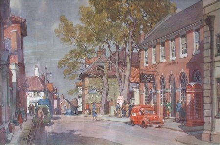
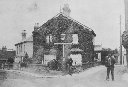
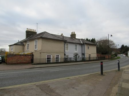
The one of the earliest photographs of the buildings on the southern side of the entrance to Cumberland Street is shown on the right. These two buildings replaced the house which is recorded in the 1840 Tithe Map and Apportionment. The building with frontages on both Quay Street and Cumberland Street was Woodbridge's first Post Office. It opened in 1874 and its first Postmaster was Miss Emma Neal. By 1934 the Post Office required more space so it was moved to a new building further up Cumberland Street. For some time the ground floor of the former Post Office was used as a hat shop.
From about 1925 the adjoining building, which had a whitewashed cement cladding, was used by A J Garnham – Jobmaster and Funeral Carriage Proprietor. Both buildings were demolished in the 1960s and then replaced by an angular redbrick building which, over the years, has attracted many derogatory comments. On the ground floor there used to be a branch of the Nat West bank and the Golden Panda restaurant. The Nat West branch closed in 2019 and has been replaced by a Blue Salt Restaurant. The accommodation on the upper floor has also been improved but the building remains out of character with its surroundings. A photograph of the building on southern side of the entrance to Cumberland St in 2000 is shown below. The building adjacent to it is Eden Lodge.

The Post Office and its staff

The entrance to Cumberland St in 2020

The entrance to Eden Lodge in 2015
The entrance to Eden Lodge (formerly The Grove) used to be wide and was lined by trees and shrubs. The two trees near the pavement grew so large that people thought they were a hazard and so their tops were taken out.
In 1950 two rather nondescript flat roofed buildings were put either side of the entrance. One was single storey and is currently a florist. The other is
a two storey building on the right of the entrance. It is currently a council run facility for children.
For a time Eden Lodge was used for offices. Woodbridge Power and Light Company, which became Eastern Electricity was the first to occupy the building. After that it was used by Woodbridge District Council and then Suffolk County Council’s Social Services Department. In 2017 it was sold and turned into apartments.
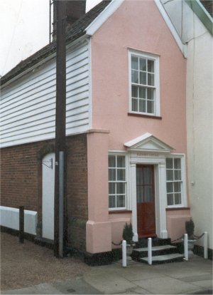
In 1934 the Post Office required more space so it moved into No 9 Cumberland Street. This imposing redbrick building has a 16th century ceiling and staircase. It is possible that it had once been the residence of the Postmaster. A rear extension was added to provided a bigger sorting office and in 1990 the counter service was moved to Budgen's supermarket in the Turban Centre. By the 1960's over 80% of the rear garden of Eden Lodge was used for a Telephone Exchange, a substation and access to the sorting office.
Painting showing the relocated Post Office and the
two imposing trees by the entrance to Eden Lodge
A short way down Cumberland Street there is a narrow entry to Athenrye Court. On the right of the entrance is Barton's Cottage. Bernard Barton (1784 to 1840) was a Quaker and minor poet who earned his living as a clerk in Alexander's bank on Church St.. His many volumes of verse now gather dust but in his day he was widely known as "the author of much pleasing, amiable and pious poetry, animated by feeling and fancy, delighting in homely subjects, so pleasing to the English people". His father was one of the twelve men who in 1787 formed the London Abolition Committee, the committee that eventually lead to the abolition of slavery.
Barton along with Edward Fitzgerald, Thomas Churchyard and George Crabbe formed the group which called themselves the Woodbridge Wits. Barton was much loved in Woodbridge and the town's people even name a ship after him.
Athenrye Court was a long thin building at right angles to Cumberland Street and its extensive gardens reached down to Station Road.. Mrs Sybil Carthew purchased the property after her husband died in 1943 and she sold the Abbey and its 14 acres of land to the Endowed Grammar School. She went to live at Athrenrye Court until her death in 1964. She had bequeathed Athrenrye Court to the Hanover Housing Trust so that they could use it for retirement homes. They did so until the 1990's when they sold the building to raise money for their other retirement homes.
Barton's Cottage
Mrs Carthew also bequeathed money to build almshouses in 1984. They were built on gardens on the northern side of Cumberland Street, and they are run by The Sybil Carthew Trust.
Entrance to Carthew Court on Station Road
Watsham and Wildings Garage was established in 1900s. They originally occupied two old cottages that were converted into a garage. Following a fire during the Second World War a flat roofed building was erected and the garage operated there until the business closed in 1958. For some time after Deben Garage used it for a hire and it was subsequently used car business. From 1979 the first floor was used as offices by the Woodbridge Timber Company. This timber importing firm moved to the Thoroughfare in 1984.
Below these buildings, on the site of the former brewery, there was a large three storey warehouse which abutted Station Road. The building had been used by the Suffolk Seed Company.
In 1992 the builders Ingram Smith started to convert the above building into Cumberland Mews. On Cumberland Street four town houses were built. These three storey houses have features which reflect those of the buildings on either side of them. Behind them there are 14 smaller terraced houses built round a paved courtyard. Vehicular access to the courtyard is from Station Road.
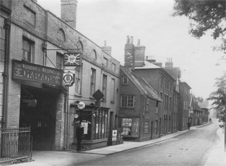
Photograph of Watsham and Wildings garage circa 1930
The entrance to Cumberland Mews is northern side of Cumberland St. The profile of the three storey apartment block on the left matches that of the warehouse which used to be on the site.
The entrance on Cumberland St. to Cumberland Mews
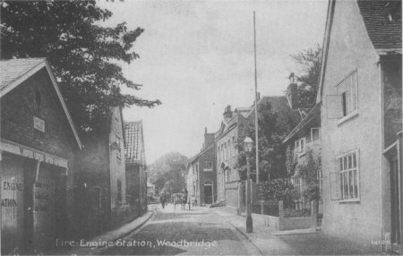
A fire engine station was erected towards the end of Cumberland Street in 1855. It was just below the two houses which had been given to the town, by William Bearman in 1661, "for the use of the poor". The fire engine station, the two houses and an adjoining plot of land were called the Town Lands. A photograph of the fire engine station and the two houses is on the right.
Before the fire station had been built the two manual fire engines were stored at the base of the church tower. During the Second World War the National Fire Service erected a larger fire station on Deben Road. This building was only of temporary construction and in 1961 the brigade moved to the new location in Theatre Street.
Sometime after 1927 the rest of the Town Lands were used as a yard by the Town's Surveyor. During the Second World War the land was used by the Civil Defence. The land was then rented to the NHS and it was used for the Woodbridge Health Clinic. It was at that time that the two houses given to the town by William Bearman in 1661, were demolished and the vacated sites were incorporated with the land rented to the NHS.
In 1960 the Poor's Houses Charity was set up and was endowed with the town lands. The old fire station was sold by the Trust in 1964. After the NHS moved out in 1996, the rest of the land was sold for housing development.
The Fire Engine Station on Cumberland St. is on the left of
this photograph. The building is now a private garage.
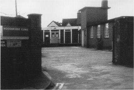
The photograph above shows the Woodbridge Health Clinic
shortly before it was demolished. The photograph on the
right shows the four houses built on the site.
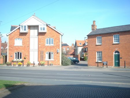
This pair of back-to-back houses at the junction of Cumberland Street and Station Road were demolished in order to widen the entrance to Station Road. Further road widening of Station Road, and an extension of Quayside to join up with the bottom of Lime Kiln Quay Road, were required to the create the Throughfare Bypass. This work was completed by 1975.
This pair of back-to-back houses at the junction of
Cumberland St. and Station Rd. were demolished
in order to widen the entrance to Station Rd
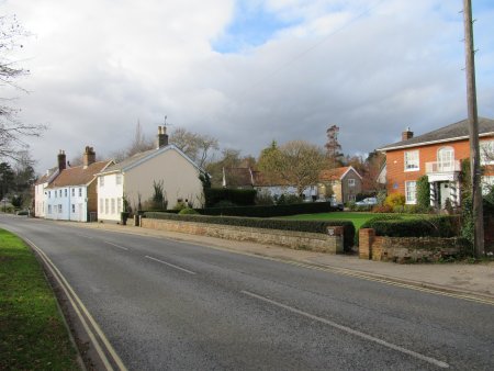
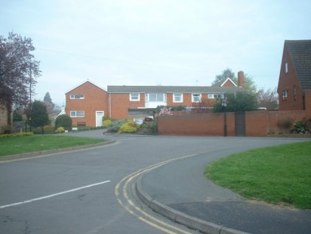
Just beyond the junction with Station Road there is Westholm, a large house which was built in the early 19th century. Westholme abutted Cumberland Street and had an extensive garden which included a lake. In 1970s the house was subdivided into three and each part was allocated a small garden. Subsequently The Housing Association built thirty-four retirement homes on most of the rest of the original garden. These houses were along Morley Avenue which is off Kingston Road. What was left of the original garden was used to create a small public garden along Cumberland Street. A path through the garden leads to Morley Avenue.
Westholm is not very attractive when seen from Cumberland Street because it is 3ft below the road. The other side of the house had a magnificent vista but much of this is now lost because of the hedge abutting the retirement homes.
Westholme in 2020.
The three buildings at the end of Cumberland Street are shown on the photograph on the right. The first building is the Cherry Tree Inn, the only remaining public house on Cumberland St. There is then an entrance leading to the rear of the Cherry Tree Inn. Then there is a dilapidated structure which might have been was an old smithy. Beyond it there are the last two buildings on Cumberland Street.
The end of Cumberland St. there are there
is the Cherry Tree Inn and two cottages.

Last edited 5 Sept 23