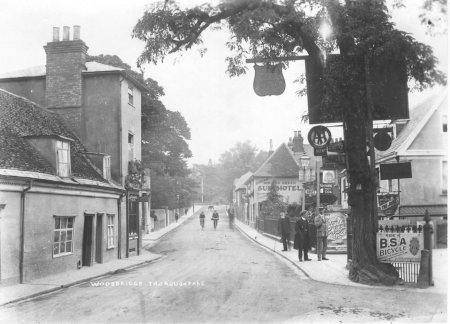
The Thoroughfare
The Thoroughfare in 1560
The earliest comprehensive description of the town is to be found in the 1560 Extent of the manor of Woodbridge late Priory. It is from this document, written in Latin, that the map on the right has been derived. The road layout is based on the 1881 OS map. What we now call the Thoroughfare and Cumberland Street was Le Throughfare in 1560.
Within the parish boundary of Woodbridge, there were plots of land belonging to a number of other manors. Such plots are only mentioned in the Extent if they abut plots of land belonging to the manor of Woodbridge late Priory. Most of the land belonging to other manors, principally the manor of Woodbridge Ufford, and the manor of Hasketon, was below the Le Throughfare but within this area there was some land of the manor of Woodbridge late Priory.
The coloured dots on the map to the right indicate the approximate location of the dwellings and commercial buildings listed in the Extent. By 1560 there were more buildings along Le Throughfare than along any other street in Woodbridge.
Woodbridge Market had been established in Woodbridge in 1172 following the grant of a Market Charter to the lord of the manor of Woodbridge Priory. A charter to hold two fairs per year was probably granted at the same time. The market was held on Market Hill which was adjacent to the parish church of St Mary's.
At Woodbridge Market there was a burgeoning local trade in livestock, leather, meat, dairy produce and vegetables. The market was dominated by butchers and leather workers and, in the 1440s, the manorial income from butchers' stalls was four times that generated by bakers and grocers.

Map showing the locations of the dwellings
recorded in the 1560 Extent
By the fifteenth century all markets were increasingly facing competition from shops because the latter were open daily. The best local example is Ipswich where, throughout the 1460s and 1470s, there were attempts to ensure that butchers sold their produce from market stalls at fixed times, rather than from their own homes where their hours of business were more flexible.
In 1756 the lord of the manor of Woodbridge late Priory requested legal advice on what to do about some butchers who refused to close their shops on market days. He was also concerned about the ‘shopkeepers who were buying butter cheese and other such commodities coming into this town to be sold before the said commodities are taken into the market'
By 1800 it is clear that the lord of the manor of Woodbridge late Priory had ceased to exercise his market rights. Although the market was still taking place he was no longer erecting stalls on the Market Hill and he was not collecting tolls or stallage on market days.
During the first half of the nineteenth century various trade directories describe the market as being plentifully supplied with corn and cattle. The earliest photographs of Woodbridge market show livestock in pens.
The only way of estimating the number of shops during the eighteenth century is to use an Excise survey of 1759. According to this source there were 15,113 shops across Norfolk and Suffolk serving a population of about 512,000. On this basis there were 34 people to every shop and, if this were the case for Woodbridge, there would have been about 60 shops in the town. It is thus not surprising that, in a 1756, the lord of the Woodbridge Market was complaining of the loss to trading to shops.
Many of these shops were likely to be petty shops, small shops which typically sold candles, bread, small beer and a diverse range of small articles to artisans and labourers, but there would also have been bigger shops selling meat, groceries, clothing, draperies and household goods to the more affluent.
The next record of the number of shops in Suffolk was produced in 1789 when a tax was levied on those having an annual rent of greater than £5. The data for some towns, including Woodbridge, has not survived but that for Beccles and Bungay has. Using the data for these two towns, which were comparable in size to Woodbridge, it is estimated that there were 44 shops in Woodbridge having an annual rent of greater than £5. This is somewhat smaller than the 60 estimated using the 1756 data but this number included shops with an annual rent of less £5.
By the early 1800s Le Throughfare was split into two. The section from Cross Corner to the parish boundary with Melton was the Thoroughfare and the section from Cross Corner to Ipswich Rd. became Cumberland St..
Shops were to be found on most of the streets in 1844 but, by 2004, most of the shops were on the Thoroughfare, Church St, Market Hill, New St. and Cumberland St. Only The Thoroughfare had more shops in 2004 than it had in 1844. The Thoroughfare is now the commercial heart of the town and is the focus of attraction for locals and visitors. Far fewer people now come to the Market Hill, the historic centre of the town. The change in the distribution of the shops about the town is clearly indicated by the map to the right which gives the number of shops on each street in 1844 and 2004.
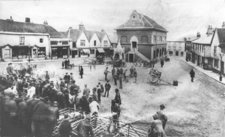
Woodbridge Market circa 1880. All the stalls and pens
were on the upper part of what is now Market Hill.

The changes in the number of shops on each
street in the town from 1844 to 2004.
The changes to the houses, shops and other commercial buildings on the Thoroughfare since 1840 are described in the next section. That start date is chosen because a tithe map and apportionment of Woodbridge in 1840 and the earliest compressive directory and gazetteer of Woodbridge was published in 1844. Together they provide the earliest comprehensive description of the town.
Changes in the Type and Number of Shops and Other Commercial Premises since 1840
From 1823 to 1844 the number of shops listed in the directories increased by 83%. Some of this increase could be attributed to the population of the town rising by 24% over the same period but it could also be due to the 1823 directory not including all shops. By far the biggest change was in the number selling wearing apparel or food.
Over this period the population of the town remained static after a 13% fall following the arrival of the railway in 1859. The number of shops in the town decreased by 24% between 1844 and 1874 and then rose by 8% over the period 1874 to 1925. The types of shop did not change significantly over this period. By far the largest number sold either food or wearing apparel or both. These commodities were the bare necessities and most families could afford little else. The same pattern has been found in towns across the country.
The food was usually prepared and packed on the premises. Butchers slaughtered their own animals, bakers made their own bread, and provision merchants sliced their bacon and cut butter and cheese from blocks. Many clothes and shoes were still made or altered in the shops. Because of the large amount of manual labour involved in the retail trade, both the number of people employed, and the number of shops needed to service a given population, was greater than today. Many photographs of the shops on the Thoroughfare have some or all the staff lined up outside and they clearly show how labour intensive the retail trade was.

Smith’s butchers shop on The Thoroughfare.
It was by the entrance to New Street.
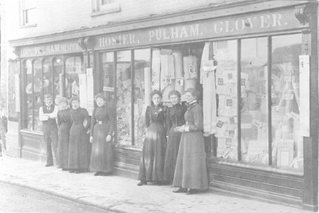
Pulham - fancy draper, hosier and glover - on The Thoroughfare.
It was in the building which is now Peacocks.

Tyson’s grocery store on The Thoroughfare.
It was demolished in the 1960s to make way for the Job Centre.
The most significant change in the type of store was the introduction of department stores and chain stores. Woodbridge’s first department store was Wrinch and Barnes at the junction of Church St. and Cumberland St.
The first department store on the Thoroughfare was started by R H Rowland after he took over Issit and Dunnett’s ironmongery business on The Thoroughfare in 1873. He subsequently built up a department store which sold a comprehensive range of goods. A photograph of the store is shown here as in an advertisement which gives an idea of the range of goods on offer. The business closed in 1936 and, sometime after the Second World War, the premises were taken over by F W Woolworth.
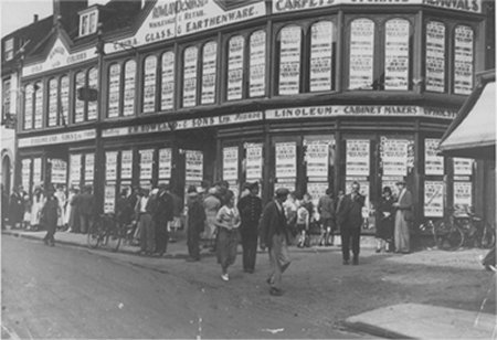
R H Rowland’s department store on The Thoroughfare. After the Second World War the building was taken over by F W Woolworth. They closed in 2009 The building is now occupied by Lloyds the Chemists and Fat Face.
Some retailers increased their profitability by opening branches in new areas and became known as chain-stores. Between the 1870s and the mid-1890s, most chain stores sold either footwear or grocery. Then there was a marked growth in chain stores selling either meat, men's clothing, women's wear or chemists' goods.
The number of such stores in Woodbridge is shown by this table. In 1874 the only national chain store in the town was Clark’s Boots and Shoes. The other chain stores were all confined to south east Suffolk. They included the draper Footman & Pretty and the grocer Joseph Turner which were both offshoots of shops in Ipswich. They were both still in Woodbridge when, in 1892, they joined by two national chains - The Industrial Co-op Society who had a branch selling groceries and an outlet of the boot manufacturers Freeman, Hardy & Willis.
By 1937 the local chain stores had left the town and the two national chains which were here in 1892 were joined by three others. These were the London Central Meat Company, The International Tea Company and Walker’s grocery store.
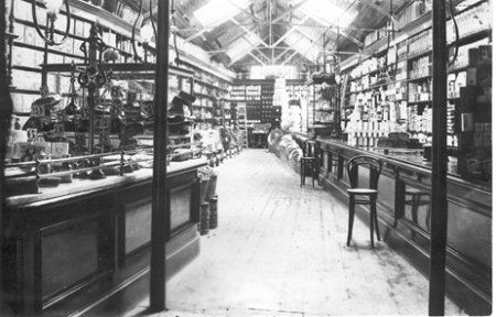
The interior of Walker's grocery store
(now part of Barretts furnishing department).
Changes in the number of chain stores in Woodbridge

During the 1930s retailing was transformed. The number of food stuffs coming ready packed increased as did the number and range of ready-made clothes. The buying process became less time consuming for the customer and consequently fewer food shops and clothes shops were needed to serve a given population.
Then, with rising prosperity during the 1950’s, there was a demand for luxury goods such as carpets, furniture, radios and refrigerators. When the house had been furnished there was a rapid expansion in shops dealing in other luxury goods – jewellery, books, records, sports equipment, cameras and a succession of new products. To meet this new demand there was a growth in the number of shops selling luxury goods.
By the mid 1960s retailing in the town was still in transition. There were still a number of butchers and grocers in the town but by 1985 many of them had closed. This was due to the rapid growth in the number of supermarkets during the 1970’s and they now dominate the retail trade. Because of the rise in car ownership, many of the new retail outlets were located in or near the larger urban centres and this resulted in a noticeable reduction of the number of food shops in the smaller towns. The growth of large chain stores selling clothing in the cities had a similar impact on the number of shops selling wearing apparel in small towns.
Most of the independent shops left in the smaller towns like Woodbridge have to either specialize in niche products and/or to attract customers who value personal attention. As a result the number of shops has fallen slightly since 1985.
The independent shops are now facing a new threat. Over the last few years many of the big chain stores have spawned smaller outlets and these are increasingly appearing in the smaller towns. In Woodbridge the number of chain stores has risen from 5 in 1937, to 13 in 1985, to 15 in 2004. If this goes on unchecked there is a danger that the high street will loose its individuality and it will become the same as in many other towns. Maybe the closure of some chain store because of the COVID virus will enable more specialist/individualistic businesses and shops to return to the Thoroughfare.
Despite a reduction in the number of shops in Woodbridge, the main retail areas still seem to be busy. This is because some of the shops which have disappeared have been replaced by travel agents, estate agents, hairdressers, banks and building societies. The number of public houses has also reduced but this has been partly compensated by a dramatic increase in restaurants. These changes are summarized by table on the right.
Shops were to be found on most of the streets in 1844 but, by 2004, all but a few shops were on the Thoroughfare, Church St., Market Hill, New St. and Cumberland St.. Only the Thoroughfare had more shops in 2004 than it had in 1830. The Thoroughfare is now the commercial heart of the town and is the focus of attraction for locals and visitors. Far fewer people now come to the Market Hill, the historic centre of the town.
Changes to the type and number of business in Woodbridge

Sometime between 1842 and 1844 Jas Bendall established an iron and brass foundry near what is now the junction of Lime Kiln Quay Road and The Thoroughfare. The foundry eventually became known as Bendall's Agricultural Implements and Engineering Works which produced foot ploughs and other agricultural implements and machines as well as wire fencing.
In the 1880s the foundry was taken over and its products were expanded to include a range of gas fittings and gas scrubbers. In 1894 the foundry changed hands again and an advert states that it was prepared to make 'castings of every description. The foundry closed in 1903 and six years later the premises was acquired by Adams Cycle and Motor Works. They were the makers of the St John pedal cycles and they became the first to cater for motorists in Woodbridge. The photograph below shows the entrance to their premises in 1920.
From 1925 to 65, Potter & Bensley motor engineers occupied the foundry site. It was subsequently used by agents for agricultural equipment and then as a car show room and garage. Adjacent to the show room was an elegant house. These buildings are shown in a photograph taken in about 1967. By then Hennessy Engineering had taken over the garage and the show room. They were both demolished in 1986, along with the elegant house to the left, to make way for Suffolk Place, a complex of retirement flats and some individual dwellings.
Two buildings on the opposite side of the road were demolished in 1975 to widen the entrance to Lime Kiln Quay Rd. when the Thoroughfare bypass was built. (Also known as South-east Link Road.)
The foundry is the building on the right of the photograph.
Sadly it is the only image which has survived.
The entrance to Adams Cycle and Motor Works
is on the right of this 1920 photograph.

By the time this photograph was taken in about 1973 Potters garage and show room had been taken over by Hennessy Engineering
There are four locations on the Throughfare where buildings or groups of buildings have been demolished since the 1960s and replaced by modern ones.
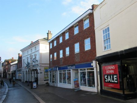
The cherry-red brick building, in the centre in of the photograph on the right, replaced a white, three storey house in the 1960s. The new building had three commercial units on the ground floor and there were flats on the two upper floors. Apart from matching the height of the adjacent buildings nothing else has been done to echo features of the white, well balanced and ornate building on the left. The least that could have be done to blend it in with the adjacent building is to apply masonry paint to the brickwork.
In about 2015 the ground floor was changed to create one large unit for W H Smith and a small unit for a coffee shop.
The red brick building in the centre of this photograph
is the most recent to appear on the Throughfare.
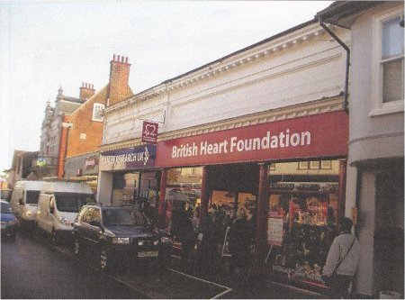
The shops in the photograph on the right is on the site of a building which was demolished in the early 1960's. The height and shape of the new building fits in well with the surrounding property as does its light red bricks. The new building was originally occupied by a Gregg's supermarket but the ground floor has since been spilt into two commercial units.

The line of buildings on the left hand side of this photograph are united by having the first floor overhanging the ground floor. The building with the darker brick was built in the 1960 and the two buildings with light red bricks were built later. The entrances to the three buildings are set further back from the rest of the buildings and this creates a pleasing variation.

The last of the post 1960s buildings was erected to provide a Job Centre and offices of the Department of Employment.
At the end of the Thoroughfare there used to be an impressive white brick residence with extensive gardens which ran down to the railway. Between it and the boundary with Melton is a similar residence with a somewhat smaller garden. It remains to be seen whether on not these buildings are to be demolished.
In 2015 the Suffolk Coastal District Council announced that it was going to move its offices to newly designed building on Riduna Park, Melton and to sell its current offices to a housing developer. In 2017 the East Suffolk Council moved to Riduna Park The old offices were boarded up for 5 years and it is only recently that demolition of most of the offices has started. It remains to be seen what will be built on the site.

Most of the buildings of architectural interest are houses towards to the eastern end of the Thoroughfare but there are also some commercial buildings of note. The photographs used here are all taken from a Woodbridge Conservation Area Appraisal produced by Suffolk Coastal District Council in 2011.
The first set of photographs show buildings on the southern side of the Thoroughfare starting at Cross Corner. The second set show buildings on the northern side.
No 4 is a former bank which was designed by J A Sherman
of Ipswich in 1909. Sadly some of its elegance is hidden
by the large and brightly coloured modern fascia.
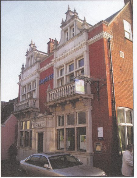
No 8 is a bank designed by T W Cotman of Ipswich
in 1895. Looking like a Victorian Town Hall,
it towers above its neighbour
No 40 is a shopper's paradise. It was built in 1846 but it has
an earlier core. The facade is in a 'Free Renaissance' style
suggestive of a Venetian Palazzo.

The entrance to the Turban Centre spans No. 58, 58a, 60 and 62.
The fluted columns, capitals and their entasis is a correct
interpretation of Greek Doric.


Park House (No. 76) and Selwyn House (No. 78)
are 'modernised' Georgian houses.

No. 100 is set back within a forecourt garden, enclosed
by a hedge and brick wall and containing a high fir
tree which dominates the area.

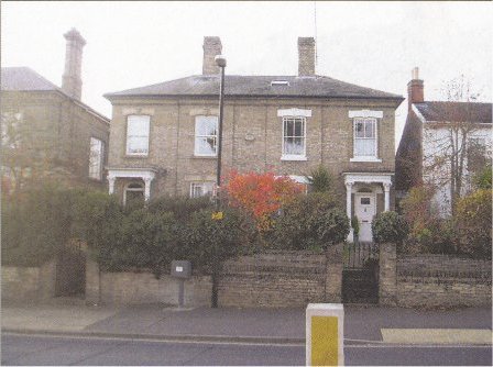
Norfolk House (No. 71) is the most impressive of line of five three storey houses.

Framfield House, No. 71 is arguably the
largest house in the town.

St Johns Lodge, No. 85 the Thoroughfare, is early 18th century in style and catches the eye of the passers by. However, there are features of the building which suggest that it was erected in the early 19th century.

Jewson's show room, on the junction of Sun Lane and
the Thoroughfare, stands out because it looks Art Deco.

No. 95 has an eye catching facade designed in the fashion of the early 19th century. The elliptical stone porch with its quasi Corinthian columns on pedestals is very fine. Perhaps the ensemble was intended to advertise the skill of the stone mason who occupied the house in the late 19th century.
No 97 the Thoroughfare is Regency in style.
It is grade II star listed.
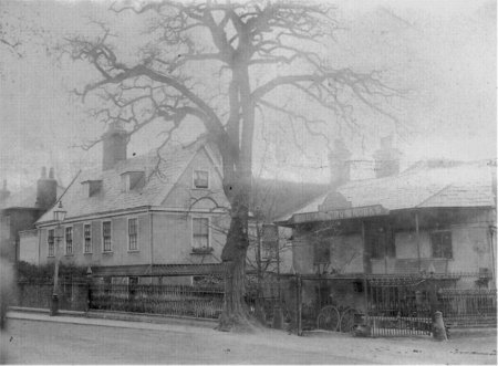
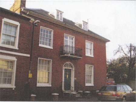
No. 99 the Thoroughfare, which is the centre of this photograph, is set back from used to be surrounded by extensive grounds. Norman Heatley, the unsung pioneer of Penicillin production, was brought up there.
No. 111 & 113 the are the most impressive of a
line of ten houses at the end of the Thoroughfare.
Two adjacent courtyards on the southern side of the Thoroughfare, and a narrow passage way between two buildings, eventually lead to an extensive development of houses, flats and shops below the Throughfare. The buildings forming the developments are shown in colour on the map to the right.
The earliest development was along what is now Doric Place. The Second Lancashire Militia were stationed at the Woodbridge barracks from 1803 to 1812. In May 1804, those officers who were Freemasons established Prince Edwin's Lodge at the White Hart Inn on Brook Street. Wealthier tradesmen of the town met officers weekly at the Inn for social and political gatherings. Amongst them was George Thompson, a surveyor & builder, who had started to build houses at the end of a narrow lane between two houses on the southern side of the Thoroughfare. This lane, which eventually became Doric Place, is shaded yellow on the map to the right.
By 1823 various townsmen set about filling the gap left by the loss of Prince Edwin's Lodge and Doric Lodge was 'inaugurated' at the Bull Inn in Jan 1824. The Lodge had a somewhat difficult time down the years and meetings were often poorly attended. By 1905 Doric Lodge had, for over eight years, been occupying rooms in a house on what by then had become Doric Place. The house in which they met has the Freemason symbol on its gable end. Its location on the map to the right is marked by an asterisk. In December of that year it was agreed to purchase land and build a new Lodge Room on land near the top of New Street. The building was opened on the 11th January 1907.
Doric Place is, and always has been, a private road. By 1840 all the buildings alongside Doric Place were as they are today. Eventually the land that used to be a rope walk became the gardens of the houses abutting the rope walk but it is not clear when this occurred.

Map showing the developments along Doric Place
and within Gobbitt's Yard
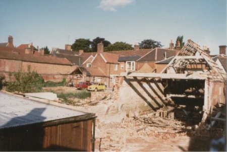
In May 1980 the Woodbridge Town Council welcomed the proposal to develop a small shopping precinct behind the Thoroughfare, with access from what used to be a carriage way entry to a rear yard of Gobbitt & Kirby Ltd.. By then an old warehouse in the yard was derelict. Planning permission was given despite objections from local traders, residents in adjacent Doric Place and from the Woodbridge Society and conservationists. The two main objections were that there would be an adverse effect on existing shops and that a three storey building which would form part of the courtyard would be too high.
Planning approval was, however, given and the Gobbitt's Yard was opened in March 1983. It consists of a courtyard with a fountain around which were grouped 11 single storey shops. Five shops were on the ground floor of a three storey building. There were flats on the two upper floors and the residents would have the use of a small enclosed garden.
As part of the development, an adjacent maltings in an adjoining courtyard was demolished and was replaced by three storey building which matched the one in Gobbitt's Yard. The ground floor was used as a covered car park and the two upper floor were flats. The pair of three storey buildings were joined together and there was a corridor linking both buildings. There was also a line of four individual garages in the adjoining courtyard.
At the bottom of the adjoining courtyard there was a building which used to be the winding house at the end of the rope walk which once produced the acclaimed Woodbridge rope. The winding house was eventually converted to a residence which still retained the arched alcoves in which the winding machinery was placed. What should have been a listed building has recently been demolished to make way for a new house.
The photograph shows that most of the space that
eventually became Gobbitt's Yard had been
cleared and that work had started on demolishing
the large maltings in the adjacent court yard.

The arched door in the centre of this photograph is
now the entry to Gobbitt's Yard
Last edited 2 Sept 23