Brook Street and the Turban Centre
Brook Street from 1560 to 1840
The earliest comprehensive description of Woodbridge is to be found in the 1560 Extent of the manor of Woodbridge late Priory. It is from this document, written in Latin, that the map on the right has been derived. The road layout is based on the 1881 OS map. What we now call the Thoroughfare and Cumberland Street was Le Throughfare in 1560.
Within the parish boundary of Woodbridge, there were plots of land belonging to a number of other manors. Such plots are only mentioned in the Extent if they abut plots of land belonging to the manor of Woodbridge late Priory. Most of the land belonging to other manors, principally the manor of Woodbridge Ufford, and the manor of Hasketon, was below the Le Throughfare but within this area there was some land of the manor of Woodbridge late Priory.
The coloured dots on the map to the right indicate the approximate location of the dwellings and commercial buildings listed in the Extent. By 1560 there were more buildings along Le Throughfare than along any other street in Woodbridge.
What is now Brook Street was originally called Le Myll Lane presumably because it was the lane leading to the Lord's Mill - the Tide Mill. Waggons from the market and from the surrounding villages would come down New Street and, and after crossing the Thoroughfare, would continue down Le Myll Lane to the Tide Mill.
The Naverne Brook flowed down the valley between New Street and Castle Street. It then ran alongside Le Myll Lane until it entered the marshes by the Tide Mill. Today the flow of the Naverne Brook is much reduced and for much of its length it is now carried by underground pipes.

Map showing the locations of the dwellings
recorded in the 1560 Extent
The earliest reference to Le Myll Lane being called Brook Lane is in the 1583 Court Rolls of Woodbridge late Priory. By 1830 it was called Brook Street in the Woodbridge Poor's Rate Assessment. Yet, when Isaac Johnson produced his 1827 map of the town, he used the local name White Hart Lane. The White Hart Inn was in a building at the junction of The Thoroughfare and Brook Street.
An extract from Isaac Johnson's map of the town in 1827 is displayed on the right. It shows the land between White Hart Lane on the left and the ship yard on the upper right. Below the buildings abutting the Thoroughfare there are extensive gardens which extend down to the marshes by the riverside.
The 1560 Extent also mentions what used to be the Old King’s High way. It would have roughly followed what is now Station Road, Quayside and Lime Kiln Road. But over time all traces of the riverside link between the bottom of Brook Street and what is now Sun Lane have been lost. All that remained was a footpath beside the marshes and saltings.
Extract from Isaac Johnson's
1827 map of Woodbridge.

An extract from the 1840 tithe map is shown on the right and Brook Street is highlighted by the red line. Between 1827 and 1840 nothing had changed on the western side of Brook Street, but a line of houses had been built on the lower half of the eastern side. The rest of the land to the east of Brook Street was split up into gardens, shrubbery and meadows.
Two of the new buildings are worth commenting on. Two thirds of the way down Brook Street there is a Wesleyan Meeting House (building no 287) and there is a large house on the corner of the Thoroughfare and Brook Street (building 277). The later was owned by Henry Edwards and Son - wine and sprit merchants and brewers since 1810. Just below it are two warehouses.
The White Hart Inn, which is believed to have started as a Gin Shop, was in part of the ground floor of the house and the entrance to the Inn abutted Brook Street.
Extract of the 1840 tithe map. Brook Street is
highlighted by the red line. A detailed description
of the buildings and the various parcels of land
can be found in the appendix on the 1840 to
the 1840 tithe map and apportionment.

The photograph on the right shows the Inn in early 1960s. It had two doorways on Brook Street - one for men and the other for women. Soon after the photograph was taken the building was demolished and was replaced by one which had 3 commercial units on the ground floor and flats on the two upper floors. In 2015 the ground floor was changed to create one large unit for W H Smith and a small unit for a coffee shop.
Just below the building was a bonded warehouse built by Henry Edwards & Son. One of their products was range of "high class pure fruit wines" the most popular of which was their orange wine. The company was still operating by 1937 and their female workforce used to sit outside the bonded warehouse preparing the fruit.

Preparing fruit outside the bonded warehouse - circa 1900
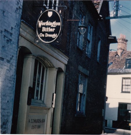
The White Hart Inn in the early 1960s, shortly
before the whole building was demolished.
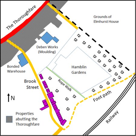
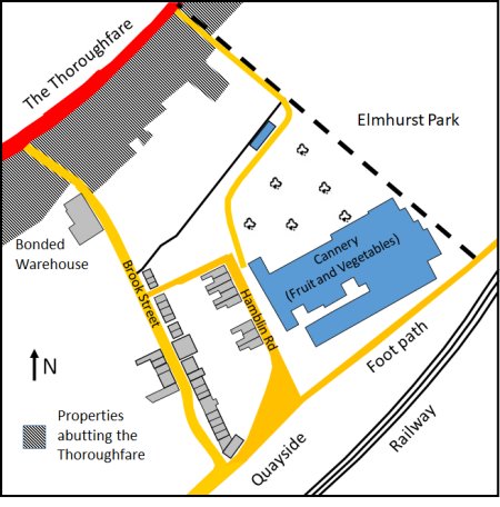
All of the significant changes since 1840 have occurred between Brook Street and the boundary with the extensive grounds of Elmhurst House. The simplified map of this area by 1882 is shown on the right. By then the size of the bonded warehouse had been increased and Deben Works (moulding) had been built. The latter was short lived. By the time the 1902 Ordnance Survey Map was produced all traces of the Deben Works had disappeared.
A new rope walk had been created by 1882 and to the right of it was Hamblin Gardens. A market garden was eventually created on Hamblin Gardens and the fruit and vegetables which were grown on it were sold at Andrew's shop on the Thoroughfare. Hamblin Gardens was one of four market gardens in Woodbridge which were supplying fresh produce to local shops.
Map showing the area around Brook Street by 1882.
The buildings shaded blue had been built after 1840.
Those shaded purple had been built by 1882
The rope walk was eventually moved to beside Jetty Lane and, by 1926, Hamblin Road was laid out and the eight houses were built alongside it. These new houses are shaded blue on the map to the right. Two other houses were added to the line of houses on the eastern side of Brook Street. They are also shaded blue on the map to the right.
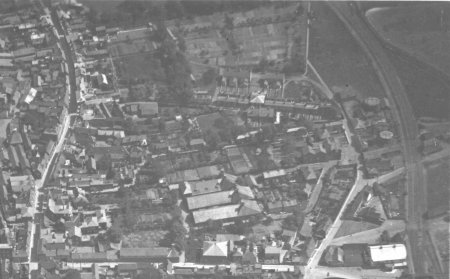
Aerial photograph of riverside taken in 1930. Hamblin Gardens
is in the top centre of the photograph which clearly shows
that the market garden is split up into various plots,
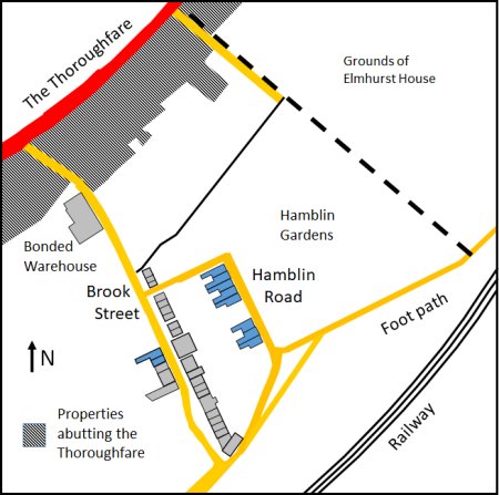
Map showing the area around Brook Street by 1926.
The buildings shaded blue had been built after 1882.
By 1933 a group of local businessmen had built a canning factory on part of Hamblin Gardens to bring employment to the town. This was the result of an initiative, by three local people, to provide much needed employment in the town. They started in 1930 with a jam factory at the top of Angel Lane and spice packing at Sun Wharf. They then sold out to a London dried fruit importer who was prepared to take over the concern and expand it. The London company built the canning factory in 1933 and increased its size several times during the next 44 years. They initially operated under the name of Woodbridge Canning Company, fruit and vegetable canners. They then operated as Turban Brand - English canned fruits. A wide variety of produce was canned including peas, parsnips, carrots, baked beans and even pigs' tails for the ethnic market. They also packed dried fruits, such as dates, and had a contract with the War Office. Seasonal employment was provided, for a mainly female workforce, until 1976 when the company moved to Martlesham Heath.
Elmhurst Park was given to the town in 1935 by Lord Woodbridge of Ipswich who was formerly Sir William Churchman. There is no evidence that he ever lived in the house which had been attached to the Elmhurst Gardens. Lord Woodbridge lived at Melton Lodge and the Churchman family, who were well known for their philanthropy, established their cigarette making business in Ipswich.
Map showing the area around Brook Street by 1966. The buildings
shaded blue had been built after 1926. The smaller of the two building is believed to have been part of the market garden.
.

The Turban Foods cannery in the 1930s. The area around
the cannery was still being used as a market garden.

The Woodbridge Canning Company in the 1960s.
By 1950 the town planners were considering measures to ease the flow of traffic through the narrow streets of the Town. A key element in their proposed solution was the construction of a new street which ran parallel to the Thoroughfare and bisected both Quay Street and Brook Street.
In 1967 the route was changed to make more use of existing roads - the road was to run along Station Road and Quayside then up what is now Hamblin Road and along the top of Elmhurst Park.
Fortunately, when the road was finally built in 1976, it went along the bottom of Elmhurst gardens rather than the top of it. Only 0.31 acres of the 4.4 acre gardens was lost to the road. About the same time as the road was built the one remaining gas holder was demolished and shortly after the canning factory moved to Martlesham Heath.
The closure of the canning factory released a significant amount of land which made it possible to transform the area between Brook Street and Elmhurst park.

The red dotted line on the map are the two routes proposed
to ease the flow of traffic through the town. Thankfully it was
route shown by the solid red line which was finally adopted.
By 2011 the whole area around Brook Street and Hamblin Road had been transformed. The buildings shaded blue had been built and four car parks and been created. All of the buildings shaded blue on the map to the right were built after 1979.
Planning permission for the Turban Centre had been given in 1981 and it was opened 1983. The entrance to the Turban Centre from the Thoroughfare was created by restructuring the ground floors of No. 58,58a, 60 and 62. The frontage of the shops either side of the entrance to the Turban centre were set back and the overhang was greatly enhanced by five Greek Doric columns and their capitals. The eleven commercial units forming the Turban Centre are marked No. 1 on the map to the right.
Hamblin Court and Elmhurst Court, which are marked No. 2 on the map to the right, were blocks of retirement flats that were erected in 1979.
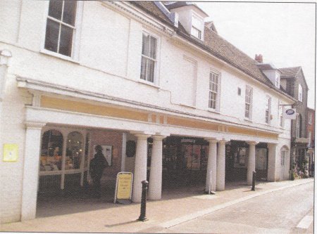
The entrance to the Turban Centre from the Throughfare
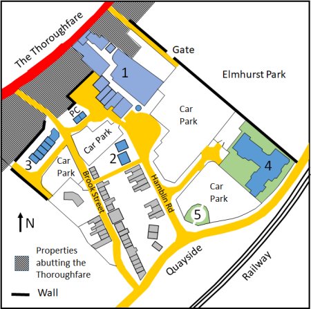
Map showing the area around Brook Street by 2020.
The buildings shaded blue were built after 1982.
Elmhurst Court, No. 4 on the map above, was built in 1989. It had 29 apartments for those who were retired.
A storm drain /reservoir, No. 5 on the map above, was installed in 2004/5 in the corner of the car park abutting Quayside and Hamblin Road. It could not be sunk to its full depth because on an obstruction. The raised platform that was left was converted into a seating area flanked by flower beds.
The final change occurred in about 2009 when the former bonded warehouse was demolished. It was replaced by a terrace of six houses which were built along Jacob's Way. They are No. 3 on the map above.
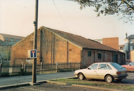
The bonded warehouse in 1966.
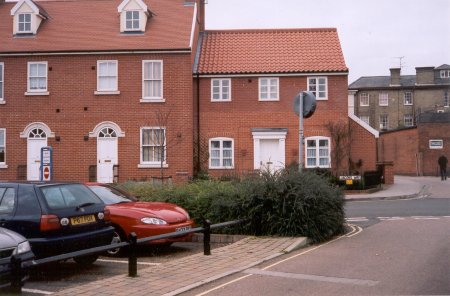
The bonded warehouse was demolished in about 2009 and was
replaced by a terrace of six houses built alongside Jacob's Way.
AHT011 Return to Introduction
Last edited 2 Sep 23