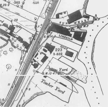
Lime Kiln Quay and Sun Wharf
The Layout of the Streets in 1560
The earliest comprehensive description of the town is to be found in the 1560 Extent of the manor of Woodbridge late Priory and it is from this document that the map on the right has been derived. What is now Wilderness Lane and Sun Lane were then called the way from Bredfield to the common at Woodbridge. The common appears to have been in the vicinity of what is now Line Kiln Quay.
From the junction of Sun Lane with the Thoroughfare, there was a road, called the Old Kings Highway. It went from a common, by what is now Lime Kiln Quay, to the bottom of what is now Brook Street. From there the road went along what is now Quayside and Station Road to join up with the road to Ipswich. Eventually all traces of the riverside link between the bottom of Brook Street and what is now Sun Lane were lost. All that remained was a footpath beside the marshes and saltings. The road between Quayside and Lime Kiln Quay was not re-established until 1976.
There is no evidence in the Extent of there being a river wall in 1560. Much of the land beyond the road from the Tide Mill to the common was described as being marsh. This accords with what George Arnott indicates in his book “Suffolk Estuary”. He says “The walls at the mouth of the river were probably built during the period between the Norman Conquest and 1500. Construction of walls higher up the river proceeded at a later date. At Woodbridge the marshes were “inned” gradually, but again there is no definite record beyond a single reference in 1660.”
In 1594 the "churchwardens and divers others of the inhabitants of Woodbridge" rented a common for 4s a year. Over the succeeding years the land was rented to a succession of people. In one of the documents the land is referred to as "a little piece of marsh ground for the use of the town". By 1660 the common had been leased for 999 years, at a rent of 10s a year, to Edward Mundy – a member of a shipbuilding family.
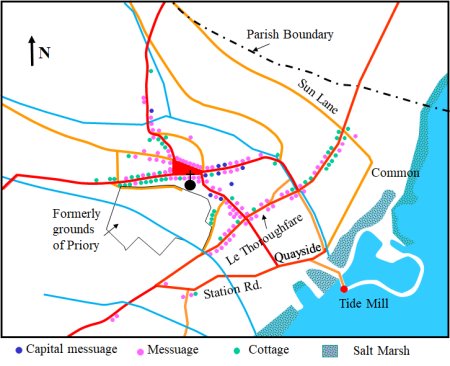
Map showing the locations of the dwellings
recorded in the 1560 Extent.
Ships were probably built at Woodbridge from at least the fourteenth century but this activity did not become a major industry until the seventeenth century. The expansion occurred because the forests of prime oaks growing on the lands of High Suffolk were a major source of timber for building men of war. Woodbridge supplied timber to the royal dockyards which Henry VIII set up at Woolwich and Deptford and demand increased after Elizabeth encouraged the Harwich shipyards to expand.
A shipyard is recorded at Lime Kiln Quay in 1625 but it likely that there was a shipyard there much earlier. At Lime Kiln Quay the channel cuts close into the bank - thus making it easier to launch ships. The lime kilns, after which the quay is presumably named, are first mentioned in a 1697 deed.
Phineas Pett, who became master shipwright of Deptford in 1599, often lodged at the Crown Inn in Woodbridge while on timber buying expeditions in Suffolk. On one such visit in 1633 he realized that it would be easier to build men-of-war in Woodbridge rather than transport ungainly logs to other shipyards. He also saw a means whereby this could benefit his family. He arranged for his son Peter to marry the daughter of Thomas Cole, the proprietor of the Crown Inn, who had become Lord of the manor of Woodbridge Ufford in 1632. By this marriage Peter Pett acquired property in the town, including the shipyard at Lime Kiln Quay, and he eventually inherited the manor of Woodbridge Ufford.
In 1637 Peter Pett built the Sovereign of the Seas at the Chatham dockyards for Charles I who wanted a ship which was more ornate than any that had gone before. Peter rose to be Master Shipwright and commissioner at Chatham Dockyards and managed to remain in that post during the Commonwealth. After the Restoration of the Monarchy he sailed with the fleet which brought the king back from Holland.
Phineas and Peter Pett were able to direct some contracts for the building of 4th rate men-of-war to the Woodbridge shipwrights Thomas Adams, Edmund Mundy and William Carey. Between 1625 and 1638, eleven ships of substantial size were built including the largest of them all, the Levant Merchant of 400 tons. Fifty years later vessels of 600 tons were under construction.
Most of these vessels were probably built at Lime Kiln Quay where the channel cuts into the bank making it the best place to launch ships. However the Suffolk Traveller of 1730 also mentions "another dock below the Common Quay, where the Kingfisher man-of-war was built, but this is now cut off from the river by a mud wall". This dock was probably the Lord's Quay which was at the end of what is now called The Avenue.
The men-of-war built at Woodridge included the Advice and the Reserve, the first two ships of the modern navy to be constructed in Suffolk. The Advice gave a good account of herself against the Dutch fleet off Southwold in 1656 and limped back to Woodbridge for repairs. Another Woodbridge ship, the Kingfisher served at the capture of Gibraltar. In 1654 Edmund Mundy built the 550 ton Maidstone which carried 40 guns. She was re-named the Mary Rose after the Restoration of the Monarchy. The last wooden ship to bear this illustrious name, she was captured by the French in 1691.

Drawing of the 550 ton Maidstone built by Mundy in 1654.
It is not known how many people in Woodbridge were involved in the ship building trade at this time, but it must have been considerable because every piece of timber had to be fashioned by hand. Woodbridge's future as a shipbuilding centre was, however, not assured. The town had no dry docks and ships were built on slipways and launched at high tides. The narrowness of the river would have also made the launching of large ships difficult.
George Arnott suggests that the building of men-of war at Woodbridge reached its peak in about 1660. After that a gradual decline set in, perhaps because timber was getting scarce or, more likely, because the Thames-side yards were expanding rapidly and were capable of building much larger ships. Also, 1n 1667, the Woodbridge yards lost the patronage of Peter Pett. His career ended suddenly when the Dutch raided the British fleet at Chatham and captured the flagship the Royal Charles. Pett was blamed for not ensuring that the dockyards were adequately defended. He was impeached by the House of Commons and was eventually dismissed.
In 1781 there had been a call in Parliament to restart building men-of-war at Woodbridge to overcome a shortage of capacity. Lord Sandwich's answer was as follows:- "Woodbridge has been tried and found an improper place - it is a bar harbour with only 14ft at HW and 4ft at LW. It is true that the 700 ton Kingfisher was built there but the using of that place has been discontinued for above 100 years, not because it is unknown but because it is judged an improper place to build it"
The 18th century is something of a blank as far as Woodbridge's shipbuilding history is concerned; few records of that time have survived. The only shipyard was on Lime Kiln quay and this then covered the strip of ground running from the Deben right up to the Thoroughfare. Samuel Turner took over the Lime Kiln yard when Edward Darley went bankrupt in 1751. He himself went bankrupt after building a 250 ton ship for the Jamaica trade in 1764. The next builder of note to operate from this quay was William Dryden who took it over in 1796. He mainly built ships for the coastal trade.
For the first half of the 19th century a steady stream of tubby little brigs and schooners were built at Woodbridge. (Cooper states that 25 brigs and schooners were built between 1816 and 1843.) The brigs went out of use in the early part of the century when they were replaced by the faster and more commodious schooners. The last of the Woodbridge brigs to be built in the local yards was the 117 tons Louisa in 1816. From then on the yards produced a succession of the faster and more commodious schooners.
In 1829 the Lime Kiln Yard was advertised for let as follows: "The premises comprise a commodious dock, enclosed building yard, ship warehouse and draft room, wharf, timber-yard, steam plank work shops, counting house, and well adapted convenience for conducting the ship-building business; together with a newly erected commodious dwelling house, situated at the entrance to the yard, commanding a view of the whole business.”
The earliest map showing Lime Kiln Quay and the adjacent area was produced by Isaac Johnson in 1811 and an extract from it is shown below. Abutting Lime Quay is Sun Wharf. Access to this wharf was along what is now Deben Road. Just below Sun Wharf there was a Lime Kiln which is highlighted in red.
In 1817 the local builder William Lockwood toured the UK to find the most suitable form of limestone to produce a cement that would have the same colour and texture of Portland Stone. His “Portland Stone Cement” was eventually based on shipping limestone direct from Swansea to the Sun Wharf at Woodbridge. This was then carted up what is now Sun Lane to the mill at Lockwood’s cement works near the Castle on what is now Castle Street.
Until 1829 Sun Lane was known as Malt Office Lane and the maltings are shown on a map produced by Isaac Johnson in 1827. When the maltings were sold in 1908 they were described thus - "Comprising a brick and timber built malting with cemented 50 coomb steep, brick working floor, 136 ft by 42 ft with large barley and malt chambers over yard at the south end of the maltings. This property has a frontage to Sun Lane of about 150 ft and an average depth of about 56 ft. The premises are held by Messrs H Edwards and Son.

Extract from Isaac Johnson's 1811 showing Lime Kiln Quay and Sun Wharf
The 18th century is something of a blank as far as Woodbridge's shipbuilding history is concerned; few records of that time have survived. The only shipyard was on Lime Kiln Quay and this covered the strip of ground running from the Deben right up to the Thoroughfare. Samuel Turner took over the Lime Kiln Quay yard when Edward Darley went bankrupt in 1751. He himself went bankrupt after building a 250 ton ship for the Jamaica trade in 1764. The next builder of note to operate from this quay was William Dryden who took it over in 1796. He mainly built ships for the coastal trade.
For the first half of the 19th century a steady stream of tubby little brigs and schooners were built at Woodbridge. (Cooper states that 25 brigs and schooners were built between 1816 and 1843.) The brigs went out of use in the early part of the century when they were replaced by the faster and more commodious schooners. The last of the Woodbridge brigs to be built in the local yards was the 117 tons Louisa in 1816. From then on the yards produced a succession of the faster and more commodious schooners.
In 1829 the Lime Kiln Yard was advertised for let as follows: "The premises comprise a commodious dock, enclosed building yard, ship warehouse and draft room, wharf, timber-yard, steam plank work shops, counting house, and well adapted convenience for conducting the ship-building business; together with a newly erected commodious dwelling house, situated at the entrance to the yard, commanding a view of the whole business.”
In November 1830 William Taylor took over the shipyard and eight years later it is clearly shown on 1838 map. An annotated extract from this map is shown on the right. The area outlined in red was being used as the shipyard and the area outlined in yellow, which was at one time part of the shipyard, was being used by a timber importer. The red dotted line marks an indent, shown on an earlier map, which was probably a slipway.

Map of the Lime Kiln Quay shipyard in 1838.
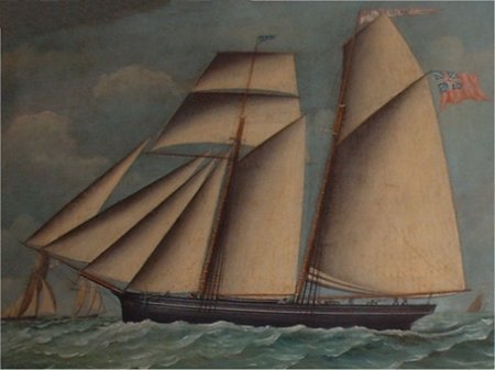
Among the schooners built by William Taylor was the Bernard Barton which was launched in 1840. Her voyages appear to have been between Liverpool and her home port, presumably carrying oil cake. The Ellen, a small schooner of 55 tons, was probably the last of these vessels to be Woodbridge built.
Painting of the schooner Bernard Barton
which was built in Woodbridge.
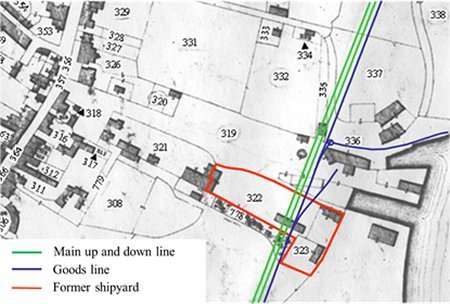
In 1850 the Lime Kiln Quay shipyard was advertised to let but there were no takers. When the East Suffolk Railway started to plan their service to Woodbridge in 1853 the shipyard was still vacant. They bought it in 1856 and four years later they had laid the main up and down lines and a goods line through the old shipyard. The impact of the railway is clearly shown on the right by overlaying the railway lines on an extract from the 1838 tithe map.
The railway lines superimposed on
a 1838 map of Lime Kiln Quay
Lime Kiln Quay Road
In 1856 the East Suffolk Railway finished laying the main up and down lines and a goods line through the former shipyard. There was, however, a level crossing which linked Lime Kiln Quay to a passage way which went up to the Thoroughfare. This passage way is shaded light brown on the extract from the 1881 map shown on the right. The passage way provided access to the timber yard, a newly built iron foundry and the volunteer drill hall. On a 1977 planning map the passage way is called Lime Kiln Quay Road. It is likely that the name was being used earlier so, to avoid confusion, the passage way will be referred to as Lime Kiln Quay Road.
An iron foundry was built some time between 1850 and 1881. It started as Bendall's Agricultural Implements and Engineering Works which initially produced foot ploughs; other agricultural implements and machines; carts; and iron and wire fencing. By the mid 1880s the company was in the hands of Mr L A Scott who started to produce a range of gas fittings and gas scrubbers. In 1889 he patented a "gas or oil burning hot water warming portable stove. The invention is a thoroughly practical and valuable one, the stove conveying warmth where circulating pipes and boilers would prove too costly. Ventilation and purity of atmosphere is ensured, thereby recommending itself to householders and others for economy, safety, utility, and health." In 1891 Scott departed to carry out extensive works in the island of Porto Rico. The business and the its 32 employees were left in the hands of his sons. The Foundry closed in 1894.
.

Extract from the 1881 OS map. The passage way
which link the Thoroughfare to the level crossing
by Lime Kiln Quay is shaded light brown.
In 1909 the former foundry site was taken over by Adams Cycle and Motor Works – the makers of the St John pedal cycles- and the first business to cater for motorists in Woodbridge. (Mr A Adams had previously operated from a shop on the Thoroughfare.)
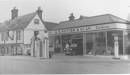
From 1925 Potter & Bensley motor engineers occupied the former foundry site. It was subsequently used by agents for agricultural equipment and then as a petrol station, car show room and workshop.
The photograph on the right shows the petrol station and show room in about 1965. The workshop was behind it and was reached via Lime Kiln Quay Road.
By 1970 eight houses had been built on what had been the Timber Yard.
This photograph of Potter's garage was taken in 1964
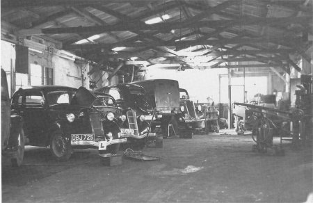
The interior of A.H. Potters workshop is shown here.
The building a First World war aircraft hanger which
was relocated from the airfield at Orfordness.
This companion photograph show the view from
Lime Kiln Quay Road looking towards the Thoroughfare
In 1950 the town planners considered measures to ease the flow of traffic through the narrow streets of the Town. A key element in their initial solution to the problem was to construct a new street which ran parallel to the Thoroughfare and bisected both Quay Street and Brook Street. But no actions were taken until 1967 when the proposed route was changed to make more use of existing roads. The new route was to run along Station Road and Quayside and then up what is now Hamlin Road and along the top of Elmhurst Park. Both routes are shown by the dotted redline on the map to the right.
Fortunately, when the road was finally built in 1976, it followed the route shown by solid red line. The new road went along the bottom of Elmhurst gardens rather than above it. Only 0.31 acres of the 4.4 acre gardens was lost to the road. The building shaded blue was a canning factory which was demolished within a year of the Thoroughfare bypass being built.
Map showing the three routes considered
for the Thoroughfare bypass.

This photograph, taken in 1964, shows Lime Kiln Quay Road
from the Thoroughfare.

This companion photograph shows the view from
Lime Kiln Quay Road looking towards the Thoroughfare.

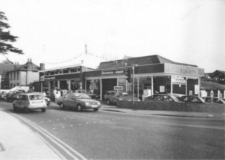
Hennessy Engineering took over A H Potter's enterprise in 1964 and eventually expanded the showroom by demolishing an elegant house on the Thoroughfare. When the Thoroughfare bypass was completed in 1976 the entrance to Lime Kiln Road was a shown by the photograph on the right.
All the changes which have occurred since the Thoroughfare bypass was built are summarized in the map on the right. It show the area around Lime Kiln Quay Road in 2011. The colour coding of the buildings indicates when they were built. The buildings around Sun Wharf and Lime Kiln Quay will be discussed in the next Section.
During the Second World War, the National Fire Service moved the fire station from Cumberland Street to what was then an open space on the northern side of Deben Road. The building was only of temporary construction and, in 1961, the brigade moved to the new location in Theatre Street. Soon after houses were built on the vacated site.
The most recent change to the Lime Kiln Road area occurred in 1989 when the petrol station, car showroom and garage on the corner of the Throughfare and Lime Kiln Quay were demolished. The site was then used for Suffolk Place, a complex of retirement flats, houses, garages and parking spaces. At the same time an adjoining plot of land on Deben Road was used for 11 houses. The final change occurred in 2011 when a second house was built on the large plot abutting the car park.
For many years Deben Road had provided access to Sun Wharf from the Thoroughfare but in 1976 bollards had been erected at the end of Deben Road to block access by vehicles.
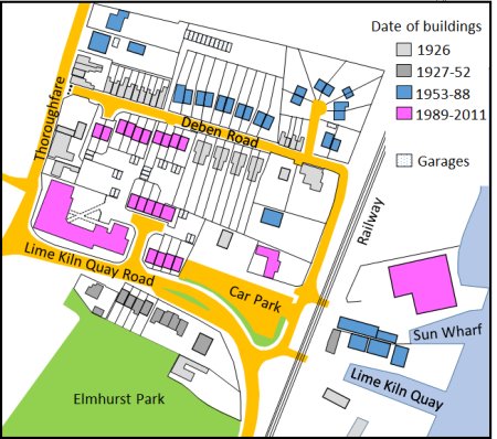
Map showing the buildings around Lime Kiln Road and
Deben Road in 2011. The colour coding indicates when
each building was erected.
Shipbuilding at Woodbridge could not, however, be killed off. This extract from the 1881 Ordnance Survey map shows that a new shipyard had been constructed on the waterfront just below the old shipyard. The new shipyard was probably the inspiration of the boat builder William Garrard in about 1860. It was taken over by Ebenezer Robinson in 1884. He laid the foundations for Woodbridge's yacht building industry and Ebenezer's son, A V 'Robie’ Robertson, gradually expanded the business.
By the early part of the twentieth century the yard became well known for its barge yachts. The flat bottoms of these yachts enabled them to sit on the ubiquitous mud of our coast at low tide, but their performance in other respects could not match yachts with keels so Robinsons eventually switched to this type of construction before the 1914-18 war.
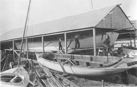
A yacht being built at Robertson’s boat yard in 1911.
The yard produced a number of very successful boats during the 1960s and 70s, and in 1992 its 28-foot cruising yacht won the accolade of 'Best boat of the show' at the Plymouth Boat Show.
Extract from the 1881 OS map.
The changes which have occurred since 1926 to the area around Lime Kiln Quay are summarized by the map on the right. The three buildings hatched in red are associated with Robertson's boatyard. The other buildings are all residential.
By 2005 repair and refitting had become the main activity of the Robertson's yard. Around 70% of the work being on wooden boats, most of which came from the Suffolk and Essex rivers, but some regular jobs came from as far away as the Channel Islands and the Isle of Man.
Since 20?? the yard is no longer owned by a Robertson but it is still a family owned business. In recent years there has been a significant investment in most areas. The main buildings have been refurbished and machinery and lifting equipment has either been replaced or upgraded. Improvements were also made to sewage treatment facilities and specialist training has been given to new staff members.
Robertson's are still keeping to its tradition of working with wooden craft but it has diversified by introducing new services such as rigging and composite deck replacements. They have also reclaimed over an acre of land to provide more boat storage space, fully serviced with electricity and water supplies.
An old dilapidated office/storage building has been replaced with an award winning modern building. It had two commercial office units and a stunning three-bedroom holiday apartment with views over the yard and river. Income from the latter helps to weather the peaks and troughs of the core boatyard business.

The buildings around Lime Kiln Quay after 1926
Between Lime Kiln Quay and the new ship yard there was another dock which appeared on the 1881 OS map but not on the 1844 Tithe map. It is also shown on the 1904 OS map. On the 1927 map it is called a Swimming Bath. Robert Simper says that the Mr & Mrs Robinson had the pool dug between their bungalow and the river in about 1910 but he does not mention the earlier dock on this site. Given the evidence for the earlier dock it is more likely that the Robinsons had mud dug out of it to make it more suitable for a swimming pool. Simper also says that the pool closed in 1940 after it was claimed that some solders picked up an illness there.
Following severe flooding in 1955 the river walls were strengthened in 1962/3 but only to withstand a surge to be expected once in 20 years. By 1990 it was predicted that, with rising sea levels, the risk of a breach was as high as 1 in 10 years and work was started to raise the bank, from Kyson Point to beyond Wilford Bridge, by 800 mm above the 1953 flood level. This reduced the risk of the town flooding to once in 250 years. Most of the area around Lime Kiln Quay and Sun Wharf was protected by steel piles topped with a concrete wall.
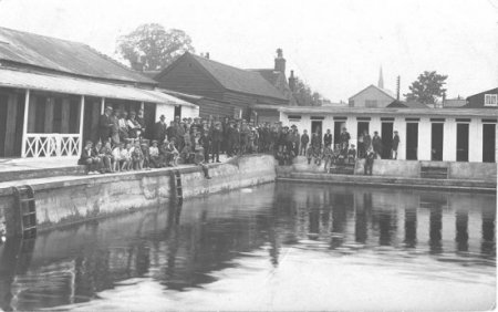
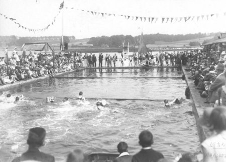
The swimming bath circa 1930
Sun Wharf, which was just above Lime Kiln Quay, had its own level crossing to Deben Road. On an 1810 map Deben Road was referred to as the way to Sun Wharf. On another map it is referred to as the drift leading to Sun Wharf. It is likely that name Sun relates to the Sun Inn was on the corner of the Thoroughfare and what is now Deben Road. The Sun Inn closed in 1970 and since 1980s it has been used as the offices of the Woodbridge Timber Company.
By the 1920s Sun Wharf and Lime Kiln Quay were used by builders, coal and coke merchants and craters (haulage contractors). The photographs on the right shows the steamer Fairy unloading coal at Sun Wharf.
The steamer Fairy unloading coal at Sun Wharf.
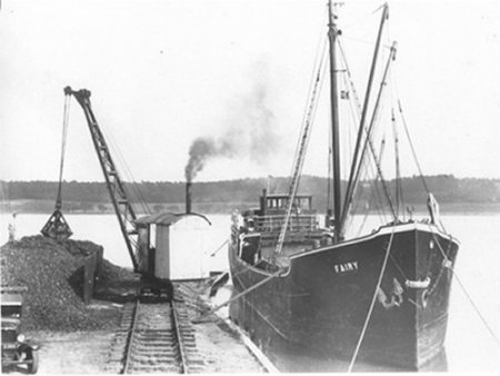
The steamer Fairy unloading coal at Sun Wharf.
Dutch coasters, brought cargoes of dried peas to Woodbridge's Canning Company warehouse at Sun Wharf for a number of years but their final delivery in 1939 marked the end of Woodbridge’s maritime trade
The railway lines remained unchanged until 1966 when Woodbridge became a passenger only station. All tracks, other than the main up and down lines were removed.

A Dutch coaster delivering dried peas to the Woodbridge Canning Company's warehouse at Sun Wharf.
By the 1960s three new industrial buildings had been built adjacent to Sun Wharf. One of them was occupied by Gibbins, who manufactured leather goods. Sadly his business was destroyed by fire in November 2012. Arson was suspected but the culprits were never identified. The business was relocated to Martlesham Heath. After the fire, Gerald Weir, bespoke furniture makers, had a large building on the site.
Barretts of Woodbridge, an independent department store specialising in high quality furnishings, have two warehouses on the site.

The area Sun Wharf after 1926
AHT012 Return to Introduction
Last edited 2 Sept 23