Brewers Lane (now Station Road) and Quayside
The Layout of the Streets in 1560
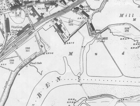
The earliest comprehensive description of the town is to be found in the 1560 Extent of the manor of Woodbridge late Priory. It is from this document that the map on the right has been derived. What is now Wilderness Lane and Sun Lane were then called the way from Bredfield to the common at Woodbridge. The common appears to have been in the vicinity of what is now Line Kiln Quay.
From the junction of Sun Lane with the Thoroughfare, there was a road, called the Old Kings Highway. It went past a common, near what is now Lime Kiln Quay, and on to the bottom of what is now Brook Street. From there it went along what is now Quayside and Station Road to joined up with the road to Ipswich. Eventually all that remained, of the riverside link between the bottom of Brook Street and what is now Lime Kiln Quay Lane, was a footpath beside the marshes and saltings. The road between Quayside and Lime Kiln Quay was not re-established until 1976.
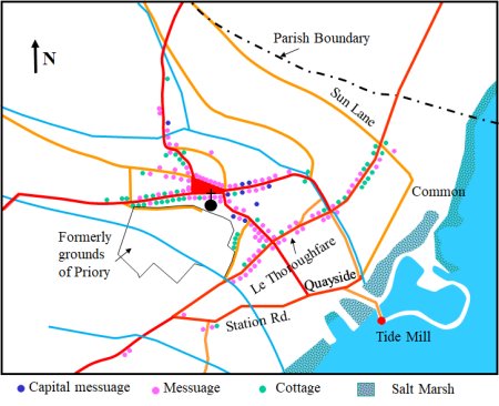
Map showing the locations of the dwellings
recorded in the 1560 Extent.
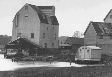
The earliest reference to a tide mill at Woodbridge was in 1170 and there is evidence that, as the mill came to the end of its working life, it was replaced by a mill at a nearby location. This has certainly happened twice, if not more.
By the 1920’s the condition of the mill was causing concern. In 1932 the mill started to falter but it was repaired. By 1938 it was only one of 9 working tide mills still operating in Britain.
When John Mathews purchased the mill in 1954. The new owner installed a diesel engine to drive the wheels but in 1957 the main shaft broke and the mill was allowed to fall into decay.
The mill pond was converted into a marina in 1964 and it was subsequently enlarged in 1994.
In 1968 the mill, the quay and the granary buildings were auctioned. The Mill and granary were purchased by Mrs Gardner who eventually donated them to the newly formed Woodbridge Tide Mill Trust. A public appeal for funds to restore the Mill was launched in 1971 and both the central and local governments gave grants towards the work. By 1976 the Mill was rescued from decay and it opened as a working visitor attraction.

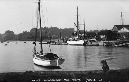
Wilford Bridge was built on the site of an old ford sometime in the fifteenth century. It was not possible to ford the river below this point, so there were at least five ferries between Woodbridge and the sea. All ferries had to be licensed by the Crown and ownership was nearly always vested in the Lord of the Manor who usually let out the ferry rights for an annual rent and often provided a ferry house for the ferryman to live in.
Woodbridge Ferry served the Sandling villages long before Wilford Bridge was built. The bridge did not remove the need for the ferry because it was still quicker for many of those walking to Woodbridge Market.
The ferry originally belonged to the Manor of Stockerland-in-Sutton. The first recorded ferryman was John Beal who in 1509 paid an annual rent of 6s 8d. As Woodbridge increased in importance, the Lord of the Manor of Woodbridge-late-Priory acquired some control over the ferry, presumably because the Ferry Quay was manor property.
In 1810 the high water ferry and the low water ferry ran from the Quay by the Tide Mill to the Ferry House by Sutton Cliff.

The routes of the high water ferry and the low water ferry in 1810
Victorian families used the Woodbridge Ferry to reach the picnic area on the Sutton Cliffs. It cost three pence to cross the river, but in bad weather, when two men were needed to row the boat, the fare doubled. At low tides the river was almost empty, so a punt was used, but the ferryman still had the difficult task of pushing it across.
In 1819 there had been a move to replace the ferry by a swing bridge but a lack of funds led to the project being abandoned.
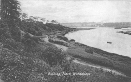
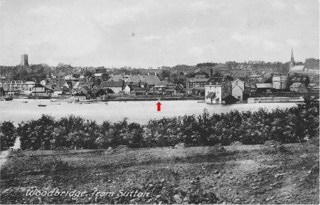
In the late Victorian era the ferry was a vital link in preserving the respectability of Woodbridge residents. The male population were allowed to swim on the Sutton side of the river where there was a sandy beach below the Sutton Cliff. Ladies swam beside the Tide Mill where there was a caravan in which they could change into their bathing costumes.
This photograph shows the sandy beach below the Sutton Cliffs
Ladies swam behind the Tide Mill where there was a caravan
where they could change into their bathing costumes
In 2003 the Woodbridge Town Council and the Tide Mill Trust, with financial assistance from the Heritage Lottery Fund and local benefactors, rejuvenated the Tide Mill Quay. This involved dredging in order to improve the mooring facilities for visiting craft. Part of the plan was to reinstate the Ferry to Sutton Hoo and thereby provide a new form of access to the National Trust's Visitors Centre. All the necessary changes to Tide Mill Quay were completed, but no attempt has yet been made to make the necessary improvements to the footpaths leading to the Visitor Centre from the proposed landing place on the other side to the river.
Produced traded at Woodbridge Market would be taken down to the quays by Quayside and Station Road and loaded on the waiting ships. Most of the markets in Suffolk just served the agricultural hinterland within a radius of about 6 to 8 miles. But coastal markets like Woodbridge had the opportunity to send produce further afield and it is likely that Woodbridge began to flourish as a port soon after its market was established in 1227. The long navigable estuary made it the natural outlet for the coastal Sandlings and the heavy clay lands of “High Suffolk”. The earliest records of Woodbridge as a trading port are dated 1350. At that time ships were taking wheat to Canterbury, consigned to the Prior of Christchurch.
By 1327 Woodbridge was, on the basis of tax returns, the 24th wealthiest settlement in Suffolk. It had about 300 inhabitants and thus just about satisfied the criteria that historians used to define a town. It was, however, much smaller than Ipswich or Bury St Edmunds which had about 5,000 to 7,000 inhabitants. The ports of Ipswich, Dunwich, Orford and Goseford all paid more tax than Woodbridge.
The first wave of the Black Death swept through Suffolk in 1349. It, and the waves which followed a few years later, killed between a third and half the population and this then remained almost constant for the next two centuries. The initial impact was devastating but the fall in population resulted in peasants having more land. Consequently their living standards eventually improved and they required better quality food, beer, clothing and footwear. This resulted in an increase in the production of meat, cheese, butter, barley, wool and leather.
The central and eastern areas of Suffolk became nationally renowned for stock fattening in general, and dairying in particular. The area was also an important region for leather production and Woodbridge was one of the six towns where tanning and leather working was concentrated by the early sixteenth century. The Sandlings produced fine malting barley and were also home to large flocks of sheep. Twill weavers were busy in the town which also developed a reputation for salt making, processing hemp and producing rope. With all this activity trade through the port increased and, in 1437, Geoffrey Kempe was allowed 'to occupy a quay of his own, for his own ships, goods, chattels and merchandise’.
River walls constructed in the seventeenth century confined the river and the resulting increase in scouring deepened the channel and this enabled larger ships to reach Woodbridge. During the 16th century, most of ships using the port of Woodbridge were small - the Partridge was 30 tons, the Marion, 10 tons, and the Delight 16 tons - although the 100 ton Marline frequently berthed at the quays. By the mid 17th century, after the river walls had been completed, much larger ships were using the quays. The Prosperous Mary, for instance, loaded 171 tons of provisions for the Parliamentary army in Scotland. By then most trading vessels and men-of-war were galleons.
For most of the sixteenth and seventeenth centuries the maritime trade of Woodbridge, and of Suffolk as a whole, steadily increased. The population of England almost doubled between 1541 and 1641 while for London there was a tenfold increase. Suffolk was well placed to meet the rise in demand for food and its farmers adopted new techniques to raise agricultural productivity. Butter and cheese were amongst the county's most important agricultural produce and large quantities of both were sent to London from Woodbridge and Ipswich. The woollen cloth industry was in a state of long term decay but the linen industry flourished during the seventeenth century, especially in north east Suffolk, and Woodbridge was one of main centre for producing sailcloth and had a linen market.
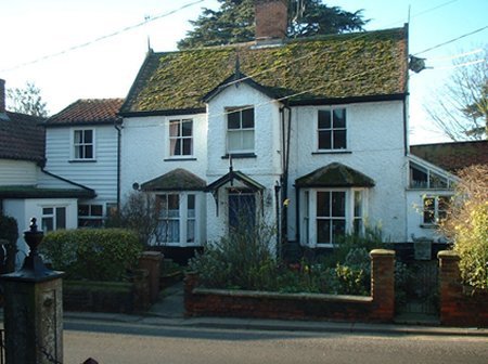
The former Customs House on Quay Street.
Woodbridge's first Custom House was established in 1589 in rented premises on one of the quays. By 1661, according to the will of Thomas Redgrave, an ‘iron house’ on one of the quays was then being used as a Customs House. Sometime later the Customs House was moved to what is now 5 Quay Street.
By the late seventeenth century the tide had turned, the importance of Suffolk to the economy of the country was declining and the maritime trade of Suffolk was decreasing. The decline was a result of the growth of the Atlantic trade with America and the West Indies and the onset of the industrial revolution in the north and west.
The ports of south-east Suffolk had other problems as well. Piracy in the North Sea during the Dutch wars of the 1650s and 70s interrupted trade and, according to Defoe, killed off the great shipbuilding trade at Ipswich. Part of Aldeburgh was lost to the sea during a series of violent and destructive storms during the seventeenth century and Southwold suffered a disastrous fire in 1659. Ipswich survived on the basis of its market functions but the port was suffering from the silting up of the river Orwell. Only Woodbridge continued to do quite well as a port exporting the produce of its hinterland.
By 1674 Woodbridge had become the fifth wealthiest town in Suffolk. Little is known about Woodbridge’s maritime trade over the next hundred years. From 1780 the economy of Woodbridge was boosted by the presence of a garrison near the town.
By 1801Woodbridge was the fourth most populous town in Suffolk. The maritime trade was past its peak but all the quays shown on this map of the town in 1827 were busy. These quays served the body of water known as Woodbridge Pool.
Two other quays were outside the area covered by the map. One was at Kyson Point to the south and the other at Melton to the north.
Corn was now the principal export of the town. It was carried by brigs and schooners many of which were built at Woodbridge. These vessels were also engaged in the coal trade to the North of England. Some also went to Liverpool for oil cake – used for cattle food - and to the Baltic after timber. Sailing these ships up to Woodbridge was a difficult and laborious task. Handling the clumsy schooners in confined waters meant frequent delays and there was often insufficient water for them to get alongside the quays. The 120 ton English Rose drew as much as 11 feet and sometimes had to wait a fortnight before there was enough water to come alongside a quay.
Map of the town and its quays in 1827

The first of the quays serving Woodbridge Pool was at the end of what is now Kingston Road. In the 1560 Extent of the manor of Woodbridge there is area referred to variously as the Le Lord's Caye and Le Quave which was on land belonging to the manor of Hasketon. It is possible that quay was the ship yard mentioned in the Suffolk Traveller. It refers to "a dock below the Common Quay were the Kingfisher man of war was built, but this is now cut of from the rivers by a mid wall and almost filled up". Later there was a warehouse there with a shoot which was used to load the holds of commercial vessels.
Then there was series of quays serving Woodridge Pool. First there was Jessup’s Quay, then Studd’s Quay, then the Common Quay, then Loft’s and Ling’s and finally Tide Mill Quay.
Adjacent to the Woodbridge Pool there were two salt pans, a salt warehouse and salt offices. It is known that salt was being collected from the edges of creeks and gullies along the upper reached of the estuary from as early as the 15th century and it was brought to Woodbridge to be refined. The last of the salt-boilers retired in 1812. By that time the facilities were just being used to refine rock salt from the salt mines of Cheshire.
During the 1830s and 40s there was a national craze for building railways. Everybody wanted one for their town and investors rushed to buy railway shares expecting much higher dividends than other companies were able to pay. By 1846 there was a London-Ely-Norwich-Great Yarmouth route and a London- Colchester-Ipswich-Bury St Edmunds route. The two routes were eventually linked, in 1842, by a line running from Bury to Norwich.
In 1847 the Ipswich and Bury Railway (later the Eastern Union Railway) gained Parliamentary approval for an Ipswich-Woodbridge line but the company then changed its mind. Woodbridge people responded, in 1851, by issuing a 'Manifesto of Discontent, which included a claim, that the town was losing trade because it had no railway.

The quays serving Woodbridge Pool in 1827
The Halesworth-Beccles-Haddiscoe spur to the Norwich-Yarmouth line was completed in 1854 by the East Suffolk Railway Company. In the same year they gained parliamentary approval to continue the line to Woodbridge. Everything was then in place for the Eastern Union Railway to build the Ipswich to Woodbridge line and for the East Suffolk Railway to build the Woodbridge to Halesworth line. After some negotiation, on the terms under which the companies could use each other's lines, the work on both started in 1856 and the line opened in 1859. It had spurs to both Framlingham and Aldeburgh.
The extent of the rail network in Suffolk by 1859. The lines
which were built from 1849 to 1859 are shown in purple.

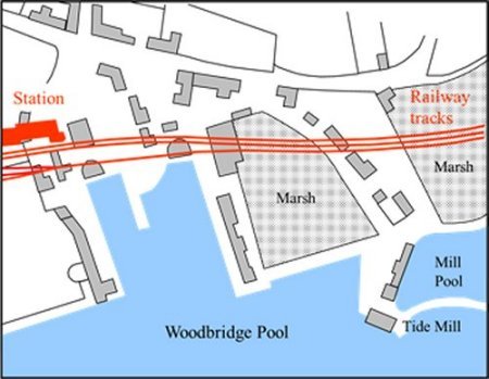
In order to keep the tracks as level as possible the line serving Woodbridge ran on the flat ground alongside the Deben estuary and skirted the top of the quays serving Woodbridge Pool. The warehouses on this side of the quay were demolished because carts could no longer access them and others had to be demolished to make way for the tracks.
In order to keep the tracks as level as possible, the railway ran on the flat ground alongside the Deben estuary and skirted the top of the quays serving the Woodbridge Pool. The impact on the quays is shown on the right by overlaying the station and the tracks onto an 1827 map.
The railway tracks and station superimposed
in red on an 1827 map of the quays
The railway had extensive goods sidings, a goods depot, cattle pens and a large grain store. These are all highlighted on the extract of the 1881 Ordnance Survey map shown on the right. The main up and down lines are coloured green while the goods lines and extensive sidings are blue. A goods line from the marshalling yard went to quays which were up river.
The station complex in 1881 was much bigger than it is today. There was an extensive marshalling yard in the area where Andy Seedhouse now sells boats and, in addition to the main up line and down-line, there was also a goods line running up to Sun Wharf Lime Kiln Quay and Melton Dock.
In addition to the booking hall and the station master's house
there was a goods depot with
three lines leading up to it. There was and a massive grain
store built to handle the corn trade which had
once been the mainstay of the port. Carts delivered
corn to two large entrances and it could then be
stored and loaded onto railway wagons whilst being
undercover. Nearby there were stables for the horses
employed to move wagons
around the various goods lines.
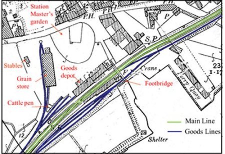
Plan of the railway station in 1881. The main up and down lines are coloured green while the goods lines and extensive sidings are blue.
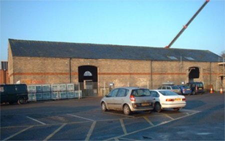
This photograph shows the grain store just before its conversion to a number of commercial units. Carts delivered corn to the large entrances and it was stored under cover before it could be loaded into railway wagons.
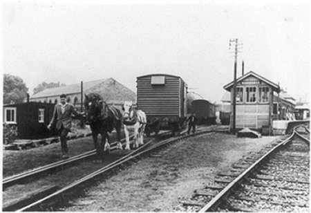
Horses were used to pull wagons on the goods lines by the station and along the goods line running to the quays up river.
When the railway started many people believed that this was the end of the town's usefulness as a port. Although water-borne transport was usually cheaper than the railway it was also very unreliable as it depended on the weather. A sailing ship could take two days or two weeks to reach London, or even two months in the winter. Despite this disadvantage Woodbridge’s maritime trade survived for another 60 years and it was road transportation that dealt the port the knockout blow.
After the railway was built about 400 vessels a year continued to carry a variety of goods to Woodbridge but the percentage which left without a return cargo gradually increased to 75% -and the number of foreign vessels fell from about 20 to 5 a year. On the 31st March 1882 Woodbridge ceased to be officially classified as a port. The Customs Office was closed and thereafter Woodbridge came under the jurisdiction of Ipswich but loaded barges were still arriving at Woodbridge quays in the 1920s and Robert Skinner used barges to sell coal along the riverside to people who found it more convenient than collecting coal from Woodbridge or Melton railway stations. The last work he could find for his barges was to carry shingle up from the Deben bar for building material. He died in 1935 and, after that the Ferry Dock was full of laid-up barges.
The station complex remained unchanged until the late 1960s when Woodbridge became a passenger only station. The goods depot was demolished and all tracks, other than the main up and down lines, were removed. Only the booking hall, the station master's house and old grain store remained. The latter was used by a. refrigeration company until being sensitively converted to residential and commercial units in 2007.
Ebenezer Robertson hoped that his son-in-law Alfred Everson would join his son Robbie at the Lime Kiln Quay boat yard but there was ill feeling between the pair. Undaunted Ebenezer, who owned the coal yard at the end of the Avenue, started Everson’s boat yard there in 1889. This yard became well known for building 12ft clinker dinghies and the 3-ton Cherub, a cabin yacht for estuary cruising. In 1912, when Alfred was fifty years old, his yard was destroyed by fire. The yards were rebuilt as the Phoenix works.
The 1939-45 war brought contracts from the Royal Navy to build craft which could be used to paint their ships. Enough material was 'liberated' from this project to produce a prototype sailing dinghy, Beaver 1, and then a second version Red Beet which became the first of the 14ft Kingfisher class. A total of 29 Kingfisher dinghies were produced between 1943 and 1963 and several examples of both the Cherub and Kingfisher classes on the Deben today. They are still looked after by the yard that built them. In addition to these craft there has been a regular production of small rowing and sailing dinghies.
In 1989 the yard passed from the Everson family to Peter Derby who had great interest in steam power with his yacht Myra. A number of yachts were fitted out in the yard using mouldings and equipment from the Pegasus Yacht Company. In the 1980s the business passed to Frank Knights and, in 2001, it was taken over by a small group of local yachtsmen who continued the tradition of individual care for many traditional and modern yachts. The group also provided moorings, winter storage, maintenance and repair.
From 2010 the name of the business was changed to The Woodbridge Boatyard Ltd to make it easier to find on the internet.
In 1889 Alfred Everson had became official time keeper and starter for all Deben Sailing Club races. He started the races from his large jetty using blank cartridges in his 12 bore shotgun.

A yacht being launched at Everson’s boatyard circa 1900.

A yacht being launched at Everson’s boatyard circa 1900.
In 1948 Frank Knights and Philip Gooch set up as jobbing shipwrights at the end of the Eastern Counties Farmers warehouse at Ferry Quay. The yard has since built about 20 boats, but the main effort has been rebuilding and servicing boats.
A fourth boat yard was created in about 1927 by Claude Whisstock on a marsh abutting the southern side of the causeway leading to the Tide Mill. This marsh is first mentioned in a 1560 document which describes “the land to the south of the causeway leading to towards the tide mill” as being “one acre of marsh, now part built on, late a parcel of le Old Myll Pond”. It is thus possible that the original Tide Mill may have been replaced when the present, much larger, mill pond was created.
The earliest map showing the marsh was produced by Isaac Johnson in 1827. By then a causeway had been built which cut the marsh off from the river. An extract from the 1827 map is shown on the right and the red dot identifies the area of marsh which was eventually used for the boatyard.

Extract from Isaac Johnson's 1827 map
In 1859 the railway arrived and the top part of the marsh was in filled to make space for the goods line which ran alongside the main up and down lines. The extent of the remaining marsh is clearly shown by the extract from the 1881 OS map on the right. This map also shows that access to the high water ferry had been moved to the centre of the causeway linking the Ferry Quay to the Tide Mill Quay. Later maps show that the marsh remained unchanged until 1927.
Extract from the 1881 OS map
The photograph on the right was taken from the other side of the estuary in about 1900. It clearly shows the causeway linking the marsh between it and the railway. The steps leading from the causeway to the high water ferry are marked by a red arrow.
This circa 1900 photograph clearly shows the causeway
and the marsh behind it.
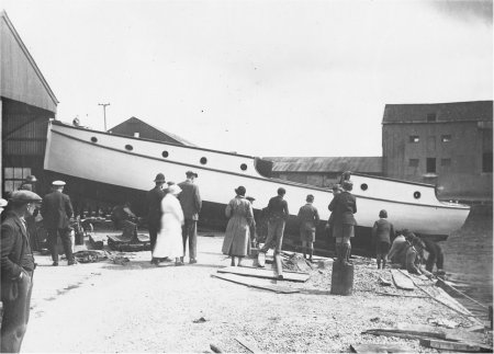
Soon after Claude Whisstock purchased the marsh, between the Ferry Quay and the Tide Mill he built a boatyard there on stilts. When his business expanded all the new buildings and storage areas had concrete foundations. The earliest photograph of his boat yard is shown on the right.

The earliest photograph of Whisstock's boat yard
A slightly later photograph, taken from the other end of the causeway, is shown on the right. The yacht in foreground is Maritza II which was built in 1937. She was the first of a series of forty one “Deben Four Tonners” built at the yard.
The photograph below shows the launching of the Orwell Viking in about 1926, It was a 40ft passenger launch which was used for pleasure trips on the River Orwell. To the right of it is a photograph of the craft after it had been fitted out. Her sister ship, the Deben Viking, was also built at the yard.
The yacht in foreground is Maritza II which was built in 1937.
She was the first of a series of forty one “Deben Four Tonners”
built at the yard.
Launch of the Orwell Viking circa 1928
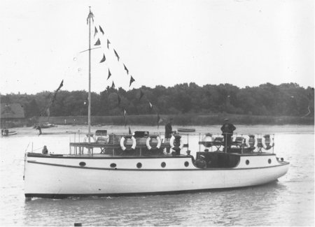
The Orwell Viking after it had been fitted out. It was
a 40ft passenger launch which used on the River Orwell.
In 1963 work began on creating a horseshoe shaped Marina as a deep water mooring for over 200 boats.
By the 1970s a larger workshop was erected to enable larger boats to be built and to allow more boats to be built concurrently. A photograph of the boat yard at that time is shown below.
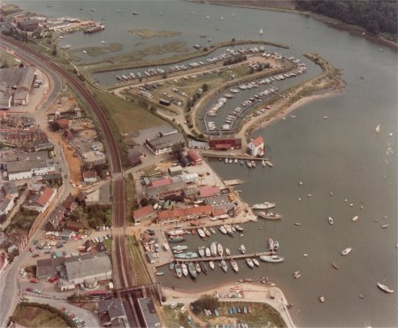

Whisstock’s boatyard flourished and it became the best known yard in Suffolk. It produced a range of wooden, fibreglass and aluminium hulled craft and established a national reputation. Eventually the boat yard filled the whole area which had formerly been marsh and, by the mid 1980s, it was as shown by the aerial photograph on the right.
The Whisstock family sold the yard in 1984 and the business soon went into receivership. It managed to start up again only to close finally in 1990. When Claude Whisstock walked out of the boatyard to start a new life in the USA the walls of his office were still decorated with photographs of the last series of boats that he had designed and built.
In 1994 the new owner of Whisstocks boat yard site applied for, and received, planning permission for the construction of office/catering / retail building and an office workshop building, renovation of existing boat shed together with associated car parking and ancillary works, including demolition of part of the existing boatyard buildings. No changes were subsequently made to the site and the application was renewed in 1998. In 2002 a new application was made - this time for a residential development. The District Council turned down the application and the developer appealed against this decision but, after a public inquiry, the Planning Inspector supported the District Council. In 2003 the owner of the site renewed his original 1998 application but once again it was rejected.
After several attempts to redevelop the site planning permission was eventually given for a mixture of residential and commercial developments, a community boat shed and a community heritage building.
A launch in 1971

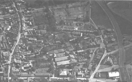
By 1859 only a small amount of land within the triangle between Quayside, Station Road, Kingston Rd, Jetty Lane and the railway had been built on. The map on the right shows the extent of the building by 1859 and the changes which had occurred by 1960.
On the 22nd Nov 1817, the Suffolk Chronicle carried the report of a vestry meeting at which the 'necessity of lighting the town was urged'. William Lockwood describes Woodbridge prior to gas lighting thus - 'At night the streets would be unlit. The gloom would only be unbroken by the flickering oil lamps outside some Hotels and large houses.'
Some time later the Woodbridge gas works was commissioned but there is no clear evidence as to when the work as completed. All that is known for certain is that, by 1838, the Woodbridge gas works was near the end of Quayside. The works was enlarged in 1872, presumably to satisfy the increased domestic demand. At about the same time the Trade Directories record the first gas fitter in the town. He was Alfred Gale who previously only appeared in the directories as an ironmonger. Gale was also agent and collector for the shareholders who owned the gas works.
The Woodbridge Gas Light and Coke Company was producing gas on Quayside until at least 1929 when the area supplied by the Ipswich Gas Light Company was extended to encompass Woodridge. The gas was then piped from Ipswich but two gas holders were retained to regulate the supply. One was removed in about 1960 and the other remained standing until the Thoroughfare and Cumberland Street bypass was built in 1976.
The two gas holders are on the left of this aerial
photograph taken in about 1935.

Buildings in the triangle railway and
Quayside and Station Road by 1859
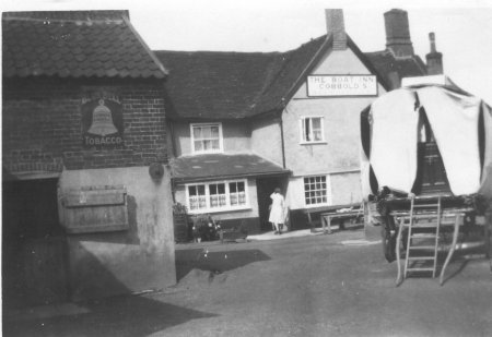
Between Tide Mill Way and the station there was the Boat Inn, a cluster of houses and a line of warehouses which had all been built before 1840. In 1957 the Boat Inn closed and it became a residence. Since then there have been no major changes to these buildings.
The Rear of the Boat Inn in 1935
By far the largest cluster of buildings by 1840 was a large tanning office and some cottages, a complex which became known as the Tanyard. The clay lands of East Suffolk had become an important region for leather production so some leather is likely to have been processed in Woodbridge.
The Tanyard was eventually taken over by Skinner’s Motor Body Repair Shop and Kay’s Engineering.
The electricity supply for Woodbridge was first supplied from a building at the corner of the Tanyard. Lambert's Almanac Retrospective for 1908 stated that the 'question of electric lighting has been repeatedly discussed (by the Urban Council), but whether electricity will eventually oust gas light from Woodbridge remains yet to be seen.' Thus it would appear that the people of Woodbridge were undecided about the relative merits of gas and electricity.
In August 1913 the Woodbridge and District Light Company switched on lights in the town. The power station had a direct current generator driven by a gas engine which used gas from the gas works on Quayside. The offices of the Woodbridge and District Electric Light Co Ltd. were at 11b Church Street.
The Tanyard power station became redundant in 1937, when the supply was switched to AC generator by the East Suffolk Electricity Distribution Company who had built a power station at Cliff Quay, Ipswich. All that remained of the generating site in Woodbridge is the distribution transformer adjacent to what is now Tanyard Court. The switch over from AC to DC was uneventful - much to the dismay of the local children who were expecting a display of sparks. The National Grid was introduced in the 1930’s and from then on the local power stations were gradually phased out.
Rope making, New Housing and the Allotment Gardens
On the 1881 Ordnance Survey map the road that we now call The Avenue is shown as Jetty Lane and there is a rope walk running along the town side of this lane. Writing in the 1950s, Arnott records that rope was made there within living memory.
As early as 1338 large quantities of Woodbridge rope, made from locally grown hemp, had been bought for the fleet of Edward III which was assembling at the mouth of the river. From the 16th to the mid 18th century Woodbridge rope was used by the navy. The production of all rope for the navy was subsequently centred on Bridgeport and the rope produced in Woodbridge was only used for merchant vessels. The main ropewalk was between The Thoroughfare and the Tide Mill but after it closed in second half of the 19th century smaller rope walks were established. One of these adjacent to Brook Lane and the other was alongside Jetty Lane.
From 1904 to 1960 houses were built along part of Station Road and along Kingston Road. Most of these houses were large and they had extensive gardens. A large plot of land abutting these gardens and the Tanyard was being used for allotment gardens.
Sometime before 1926 the Picture Theatre (cinema) was built adjacent to the entrance to the station. This building is marked A on the map to the right.
The station remained unchanged until late 1966 when Woodbridge was re-designated as a passenger only station and a year later it became an unmanned pay-train halt. The goods depot was demolished and all tracks, other than the main up and down lines were removed. Finally the signal box was demolished in 1974 having been disused for about three years. Only the booking hall, the station master’s house and old grain store remained. The latter was taken over by a refrigeration company and, in 2006 it was extensively converted into residential, office and retail accommodation.
In the 1960s the council run Glebe House was built to provide residential care. In 2001/2 the complex was completely rebuilt so that all residents could have a living room and a bedroom, rather than a bed-sitter. Between Glebe House and Jetty Lane there was a Youth Club.

2020 map showing all the key features within the triangle
of land between Quayside, Station Road, Kinston Rd,
Jetty Lane and the railway
After the last gas holder was demolished in 1976 a small industrial estate was created between the site of the former gas works, the road and the railway. The largest of the businesses was Rockford Marks who made wiring for a number of electrical and automotive companies. They moved to Eyke and, in 2003, the building became a showroom for a bedding company.
An application to build 14 flats on the site of the former gas works was rejected in 2003 and the owners soon demolished the boundary wall along Quayside and left the bricks scattered across the site. A revised application was subsequently submitted for a mix of 13 flats and 2 office units. Despite opposition from the Town Council and other local pressure groups the revised application was approved in June 2005.
The Deben Swimming Pool and the Community Centre are marked B and respectively C on the map above. They were both funded by Woodbridge Town Council. The Swimming Pool was built in 1976 and the Community Centre was completed some time later.
By 1985 Skinner’s Motor Body Repair Shop and Kay’s Engineering in the Tanyard were demolished and by 1990 they were replaced by Tanyard Court, a group of 36 retirement flats. Each flat was bought and sold independently but the management agent set an annual charge to cover ground rent and maintenance.
General Refrigeration moved out of the Grain Store in 2003 and a year later a planning application was received for a change of use. The proposal for alterations to form offices, restaurant (with a balcony overlooking the river), five residential flats and warehouse, together with construction of a vehicular and pedestrian link between the station car park and the community centre car park. After revision to change the scale to the proposed extension to the front of the building, and the size of the restaurant building at the rear, the proposal was accepted by the planning authorities. Work started towards the end of 2005.
In 2003 Woodbridge Town Council proposed to build a skateboard park at the rear of the Deben Swimming Pool on part of a site used as a coach park and recycling centre. Planning permission was given for this development but the discovery of high levels of methane gas in the area delayed work.
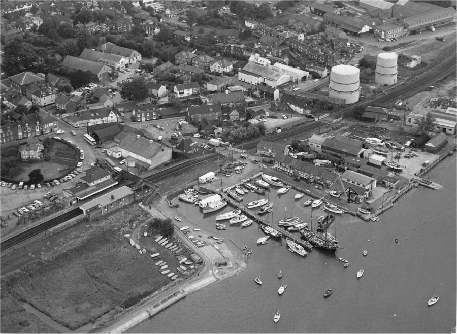
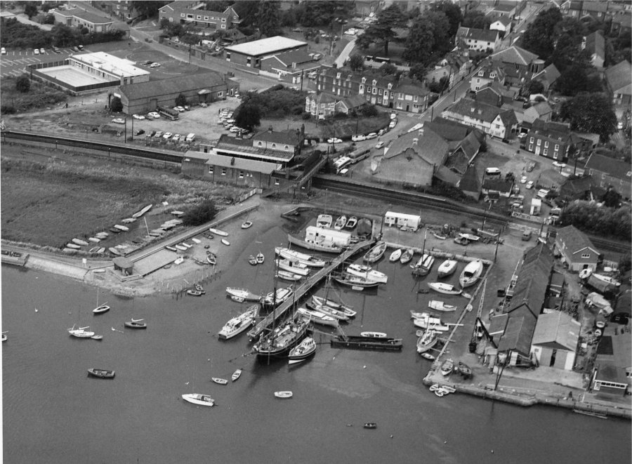
Some of the changes were underway when the two aerial photographs shown below were taken in 1973.
Last edited 2 Sept 23