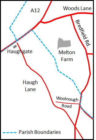
Melton Farm Area
The Layout of the Streets in 1560
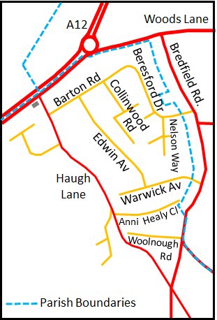
The Melton Farm area, as defined in the 1967 Town plan, was mostly between Haugh Lane and Bredfield Road.
The area also encompassed Orchard Gardens and parts of Bredfield Street and Castle Street. These additional areas are, however, not included in this account because they are adequately covered in the other area histories.
The parish boundary between Woodbridge and Melton runs through the Melton Farm area.
The earliest comprehensive description of Woodbridge is given by the 1560 Extent of the manor of Woodbridge late Priory. In this document Haugh Lane was called the way leading from the market place at Woodbridge towards Fowerway Cross. There are other reference to the field "where the cross at Fowerways one stood." Fowerways appears to have been at the junction of what is now Haugh Lane and the road from Melton to Bealings - the point where the parish boundaries of Melton, Hasketon and Woodbridge meet. Many crosses were pulled down after the Reformation.
Above what is now Haugh Lane, on the Melton side of the boundary, there was an area called Byshoopes Haughe woode.
George Arnott has found a reference to the "highway under Bishoppes-haugh woode," in a will dated 1522 and it seems likely that this was an alternative name for what is now Haugh lane. Arnott goes on to say that "it is a very old and deep lane" and that "in 1873 the remains of a man with a spear, believed to be Saxon, were discovered upon the site of the Junior House of Woodbridge School." This site was adjacent to the lower part of Haugh Lane. This lane was important enough to appear on Bryant's (1824) map of Suffolk.
The 1844 tithe map shows that, with the exception of Melton Farm, the whole area was used for agriculture.

Map showing the Melton Farm area, as defined in 1967
Changes Between 1844 and 1927
By 1927 the area between Haugh Lane and Bredfield Road was shown by the map on the right. All the roads and lanes in red were as they were in 1840.
The buildings associated with Melton Farm were still standing by 1927 but it is not known whether the farm was still operating at this time.
Woolnough Road was laid out between 1904 and 1926.
Some time between 1844 and 1927 a house, Haughgate, had been built at the northern end of Haugh Lane. This building was converted into a retirement (nursing) home in the 1990s.
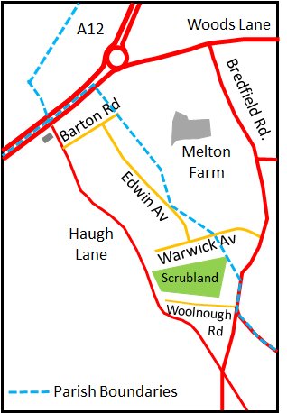
Map of the Melton Farm area by 1950
By 1950 the area between Haugh Lane and Bredfield Road was as shown on the right.
The Woodbridge bypass, part of the A12, was built in the 1930s and by 1950 Warwick Avenue, Edwin Avenue and Barton Road had been laid out and the Council had built houses along them. Barton Road would later be extended.
In March 1950 there was an auction of the remainder of the Melton Farm Estate. A map associated with the auction particulars has survived and can seen by clicking on the line below.
In 1951 Sister Doris Adams became concerned about the large population of young families living in the new council houses around Warwick Avenue. Many had were not affiliated with any church and the churches in the town were some distance away. So Sister Doris held religious meetings in any shop which became vacant.
In 1952 a hut was donated by Miss Allen of Doric Lodge and it was transported to a plot of land abutting Edwin Avenue and Warwick Avenue. It is there that The Avenue Evangelical Chapel was formed.
A youth hall was established behind the Chapel in the 1980s. The hall had originally been a battery hen house.
Map of the Melton Farm area by 1950
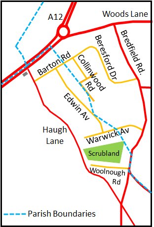
Changes Between 1950 and 1967
By 1967 Barton Road had been extended and it joined up with Beresford Drive. Collingwood Road had also be laid out between Beresford Drive and Edwin Avenue. By 1967 houses had also been built along along the eastern side of the upper part of Haugh lane.
The undeveloped land to the west of upper Haugh Lane was used for the playing fields of Farlingaye High School and Woodbridge School.
The grounds of the Pre-Prep Department of Woodbridge School (Queen's House) were to the west of the lower part of Haugh Lane.
In 1967 the East Suffolk County Council published a draft town map. This proposed further developments in the Melton Farm Area. The stretch of land to the west of the middle of Haugh Lane was to be retained as a public open space. This land abutted the cricket ground of Woodbridge School and parts of the grounds of Farlingaye High School and Woodbridge School.
Map of the Melton Farm area by 1967
In 1979 Woodbridge Town Council proposed that the parish boundary between Woodbridge and Melton should be simplified. The Council proposed that the boundary should run up Bredfield Road and then along Woods Lane. Melton Council's counter proposal was that it should be along Woolnough Road and Haugh Lane. Finally it was agreed that the boundary should run along the backs of the gardens on the houses on the Woodbridge side of Bredfield Road.
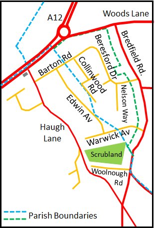
Nelson Way was laid out by 2000 and a high density development of smaller dwelling had been created between Nelson Way an Collinwood Road. There were no garages in this area and there was a limited amount of space for parking.
The only land left for development was either side of the entrance to Beresford Drive, and the scrubland between Warwick Avenue and Woolnough Road. This scrubland is shaded green on the map to the right.
Modern roads superimposed on 1838 Tithe map
Map of the Melton Farm area by 2000
Changes Post 2000
In 2003 an open space on the eastern side of the entrance to Beresford Drive was laid out as a children's play ground.
In same year, the waste land between Warwick Avenue and Woolnough Road was identified by Suffolk Heritage Housing Association as a potential site for low cost housing. The application to build 33 houses on the site was strongly resisted by some local residents and in April 2003 the planning application was rejected on the basis that the proposed number of houses was too many for the site.
A revised application to build 32 houses and flats was eventually accepted in July 2004. Work started on the complex in the summer of 2005 and was completed in late 2006. There was already a spur road from Haugh Lane leading to waste land and when the road was extended it became Anni Healey Close.
In 2005, Suffolk Coastal District Council announced the land on the southern side of the entrance to Beresford Drive was sale and that it could be used for housing. Planning permission for a residential development was granted in same year.
Following a bequest for one of the congregation of The Avenue Evangelical Chapel, work started in March 2005 to build a new Chapel on the site of the old one.
Work to expand Haughgate Nursing home from 17 beds to 31 started in June 2005.
In 2007 three houses were built behind Queen's House on Woodbridge School land. The development was named Bursar's Close. Access was via the bottom part of Haugh Lane.
Map of the Melton Farm Area in 2000
AHT016 Return to Index of Area Histories
Last edited 8 Sept 23