Peterhouse
The Layout of the Streets in 1560
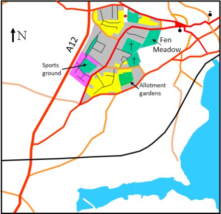
The 1967 Town Plan defines Peterhouse as the shaded area on the map to the right. The area is bounded by the A12, the Ipswich Road and Grundisburgh Road.
Peterhouse includes part of Seckford Street and Drybridge Hill but, as both of these areas are included in the the account of Seckford Street and Drybridge Hill, they will be omitted from this account of the history of Peterhouse.
In the 1560 Extent of the manor of Woodbridge late Priory, the road we now call Old Barrack Road was variously called the "way from the market place in Woodbridge to Seckford" and "way from the market place in Woodbridge towards Martlesham."
Old Barrack Road may have existed in the eleventh century when Bigod’s Way linked Earl Bigod’s castles in Framlingham and Walton (Felixstowe). George Arnott cites evidence that this way used to run down Gazebo Lane. If so, Bigod's Way could have continued on along what is now Old Barrack Road and then skirted the town and carried on to Framlingham. If so travellers to Woodbridge would have left Bigod’s Way and gone down what is now Drybridge Hill and Seckford Street.
Alternatively, Bigod's Way could have skirted the town and there would have been a spur linking it to Woodbridge. This spur could have been Collets Walk which runs between Gazebo Lane and the top of Seckford Street.
The entries in the Extent are provide insufficient evidence to confirm or refute either of these scenarios. In the Extent there are six references to a path, variously named Walton Path and Earl Bygotts Path which cut across what is now Grundisburgh Road, and three references to a Lords Path that joined to "way from the market place in Woodbridge towards Martlesham." There is also a single reference to a path that either joined, or crossed Walton Path. It is described as "a certain path of the lord of the manor leading from Blunts to the town of Woodbridge".
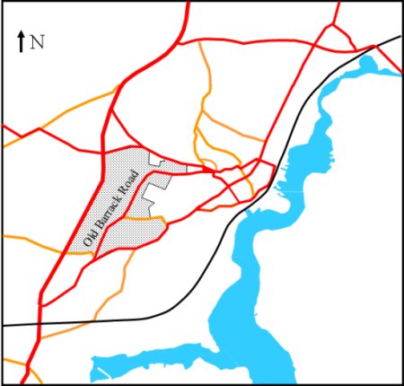
Map showing the Peterhouse area, as defined in 1967 Town Plan
Unfortunately these entries provide insufficient evidence to fix the route of Walton Path or of any spur linking the path to Woodbridge. It is, however, clear from the Extent that, if Old Barrack Road had ever been the main route from the town to Ipswich, this was no longer the case in 1560. By then it was along what is now Cumberland Street and the Ipswich Road.
Changes from 1560 to 1844
In 1795 the road between Ipswich and Great Yarmouth became a Turnpike and the maps from that period show that it went along Ipswich Road and Cumberland Street and not along Barrack Road.
During the late 18th century, coastal defences were erected to counter the threat of invasion by the French. This turned South-East England into an armed camp with Martello Towers being built to repel the enemy and garrisons being stationed at strategic points. There were signalling systems to warn the local population of invasion, evacuation routes were planned and troops and seamen were recruited.
The flat, sparsely inhabited, coastline of this part of Suffolk was particularly suited for a hostile landing. To counter this threat a garrison of nearly 8000 men was established at Rushmere (on the east side of Ipswich) and in 1782 a tented barracks was set up at Broomswell near Melton.
By 1804 the tented barracks was replaced by a timber built barracks on the outskirts of Woodbridge. Troops from this barracks could march to defend either side of the Deben estuary. The Garrison comprised 765 Cavalry Officers and 4165 Infantry Officers and men. To alert the troops to an invasion, two signal towers (Gazebo Telegraphs) were built adjacent to the barracks. From these towers it was possible to communicate (by flags and telescopes) with similar towers at Felixstowe and Bawdsey.
The location of the barracks is shown on the right. The barracks included a large hospital and there was an Inn, The Duke of York, just outside the main gate to provide for the entertainment of the troops. The inn was at the junction of Barrack Road and the Ipswich Road, i.e. where the Seal stands today. In 1735 there is a reference to this corner being called Beggars Green.
The barracks included a large hospital and there was an Inn, The Duke of York, just outside the main gate to provide for the entertainment of the troops.
Some of the fields surrounding the barracks would have been home to the “camp followers”. They were women who followed their men (ordinary soldiers) around the country. Often they were they lived in shacks on the perimeter of the camp or barracks and they earned money by doing the troops' washing and by nursing sick soldiers. It was a pitiable life which contrasted sharply with that of the officer's families who lived in smart houses in Woodbridge and the surrounding area.
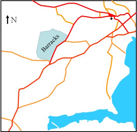
Map showing the extent of the barracks
When peace was declared in 1815 the barracks was pulled down immediately and sold for building material. The Duke of York Inn survived until 1824 when it was sold to a local builder who demolished it for building materials. The whole area soon reverted to farming and only the Gazebos Telegraphs remained.
By 1815 the Gazebo Telegraph is the only indication the barracks ever existed The map also shows the road which is now named Warren Hill Road. This road is called Deadman's Lane on the 1881 Ordnance Survey map. On the 1904 OS map it is called Cemetery Lane and on the 1927 OS map it is Warren Hill Road. The area the west of the road was called Upper Warren Hill Field in the apportionment for the 1844 tithe map. The derivation of the name Warren Hill, is unclear but it is worth noting that John Warren farmed the area in 1560.
The tithe map and the accompanying apportionment give a comprehensive view of the area in 1844 and the relevant extract from it is shown on the right.
The tithe map shows that the whole area that we know now as Peterhouse was open fields or farms in 1844. All but one of the houses in the area were on Barrack Road. The one exception, Cold Hall, was at the junction of Barrack Road and Warren Hill Road. It is shown on the map but is not identified in the apportionment. Arnott suggest that Cold Hall is so named because it stands in a cold and exposed position. It was occupied in about 1810 by a coal merchant, one John Morgan, who supplied coal to the nearby barracks.
The Gazebo Telegraph and all other traces of the Barracks had gone by the time the tithe map was produced. The farm just beyond Drybridge Hill was later to be named Barrack Farm. In the 1860s it was purchased by John Grout, the then landlord of the Bull Hotel, for his horse dealing business. In the 20th century it was used by the Suffolk Seed Establishment (Fred Smith and Company) as a seed and trial grounds.
At the lower left of the section of the Tithe map given here there is a field (160) called "shooting field". This field is on the other side of the Ipswich Road and it is possible that the soldiers from the barracks used this as a firing range. From there they could shoot across the Deben. It is said that this explains why lead bullets can be found in the mud across the other side of the river.
Extract from the 1840 tithe map showing
what is now the Peterhouse Area

In 1900 Lindsay Motor Manufacturing Company Ltd, built cars in a factory at Barrack Corner (on the former site of the Duke of York Inn) and they produced a range of vehicles. In 1905 they built ‘Tricars’ having a two cylinder engine and variable gears. The following year they produced the 4 wheeled “Voiturette” having a 6 hp, two cylinder, JAP engine, and was fitted with the proprietary Lowes variable gear. This car sold for £140 and could achieve 40 mpg. By 1908 they were producing a 11 cwt model, the L6, which sold for £470 but they ceased trading soon after.
During the first world war the site was used to house Italian prisoners of war. Jewels Garage subsequently took over the site. They moved out in 1997 and the site was derelict until it was purchased to make way for the Seal public house.
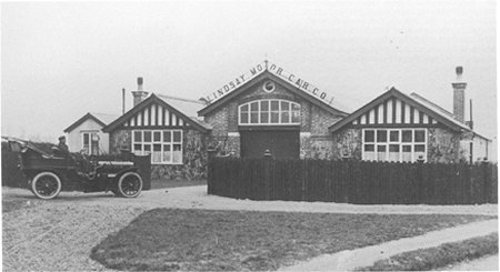
The Lindsay Motor Manufacturing Company's factory
at Barrack Corner.
The A12 bypass, which was built in 1933, was one of many such schemes instituted to bring employment. The new road cut through part of the site of the former barracks. The rest of the area, which we now know as Peterhouse Esate, was still open fields.
In the late 1930s Woodbridge Urban District Council started to build council houses to satisfy the need for low cost homes, but only 27 were erected before 1939.
From 1945 to 1951 a total of 188 council houses were built and the majority of these were on the Peterhouse Estate. The houses were built along a number of new roads which are shown in black on the map to the right. Fifty of the houses which had been erected on the Peterhouse estate between 1947 and 1948 were prefabricated - they were called "Airey Houses". These houses were made of concrete panels and could be put up quickly by an unskilled workforce.
To the southeast of the new development there was a sports ground and pavilion.
Barrack Farm, the oldest building in the area, is within the yellow box on the map to the right. By 1966 the farm had been demolished and left hand side of the vacated plot was used for the King's Court. Within it there were 18 houses laid out along three sides of a rectangle and in the centre the rectangle there were 18 parking spaces. Access to King's Court was from Old Barrack Road.
On the left hand side Barrack Farm there were six retail units set back from Old Barrack Road. In front of these retail units there was off road parking.
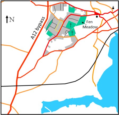
The areas shaded grey on this map show the extent
of the house building in Peterhouse by 1951
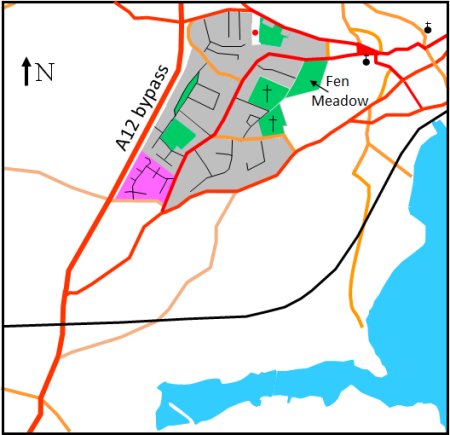
By October 1956 another 150 council houses were built, many of which were on the new roads within the area shaded purple on the map to the right. This development included moving the sports grounds to the area between Clare Avenue and Newnham Avenue.
From 1956 onwards most of the housing developments within Woodbridge was the result of private enterprise. The areas within Peterhouse where this occurred are shaded yellow on the map to the right.
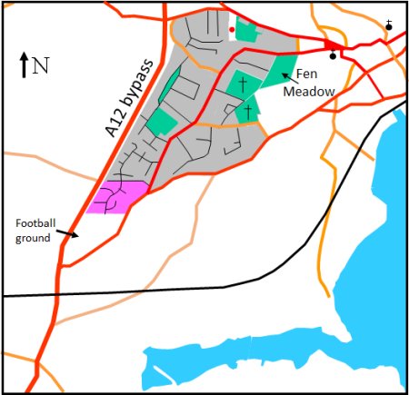
By 1970 the Kyson County Primary School was built on what used to be the sports ground.
All the new house building within the town went ahead without the sewage system that was originally intended. Work on implementing a revised scheme was started in 1963 and finished in 1964. Before this people relied on septic tanks, cesspits and the night soil men.
The areas shaped purple on this map show the extent of
council house building from 1951 to 1970. The yellow
area show the extent of houses built by private enterprise
over the same period.
By 1974 private developers had built new housing on previously undeveloped land above Seckford Hall Road. This development is shaded purple on the map to the right.
One of the first projects of Suffolk Heritage was the replacement of the replacement of 50 Airey houses that had been erected on the Peterhouse estate. By September 1992 they had been demolished and replaced by 118 new houses. This expansion was possible because the original houses had been built to a density of only 4 to the acre. They all had very big gardens to allow families to grow their own vegetables. The new houses had much smaller gardens that also included space to park a car.
The area shaded purple on this map show the extent of the building
of homes by private developers between 1970 and 1974.
In 1986 Notcutts made a planning application for the 19.3 acres of land bounded by the A12, Seckford Hall Road and the Ipswich Road. An area which had been known as Martlesham Field.
The application was for the building of 88 houses on 11 acres and the remaining 8.3 acres was to put aside for a public football ground and two cricket pitches. Suffolk Coastal District Council wanted to reduce the area proposed for housing to 10 acres but, in 1987, they accepted a counter proposal of 10.8 acres to be used for 88 dwellings of which 17 were to be starter homes. The latter were to be terraced houses facing a small green. This new housing is shaded purple on the map to the right.
Before work on this development started the Highway Authorities decided that, for safety reasons, the Woodbridge side Seckford Hall Road should no longer have access to the the A12.
In July 2005 Heritage Housing Association started to build 11 affordable homes on land between Peterhouse Crescent and the A12. The 6 two-bed, 3 three-bed and 2 four-bed are to be offered for rent to people on the housing register.
The purple area on the map above shows the
extent of new building between since 1974.
AHT017 Return
Last edited 8 Sept 23