Bury Hill
Introduction
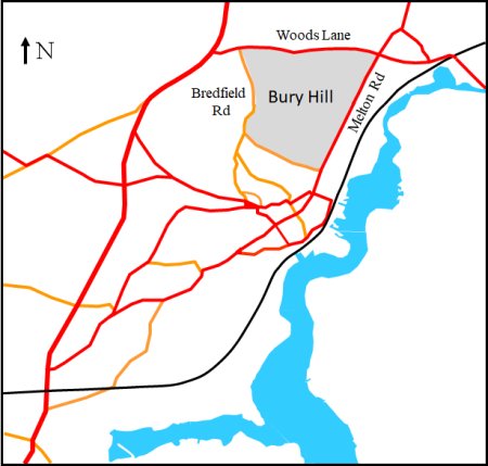
The area now known as Bury Hill is bounded by Woods Lane, Melton Road, Pytches Road and Bredfield Road. By the 1813 the two largest land owners within Bury Hill were Thomas Pytches and Richard Wood.
After the Pytches sold the Mount Pleasant Estate in 1839 it changed hands several times. By the 1960s Woodbridge and Melton were starting to expand and part of the estate was used for the first phase of new housing. By 2010 most estate was covered by housing.
The Woods family no longer live in this area. By the mid 1930s there was nobody in the family qualified to take over the legal practice in Woodbridge and those who could have lived in the Melton estate were well settled elsewhere. In 1936 the whole estate of 98 acres was auctioned in twelve lots. The legal practice in Church Street was sold to a partner in 1946. It eventually became Hubbard and Co. It then became Margery and Miller and is now Gotelee. The part of the Woods estate which was within Bury Hill has been split up but none of it has been used for housing.
The history of both families can be found in the section on notable People from Woodbridge and Melton.
Map showing the Bury Hill area.
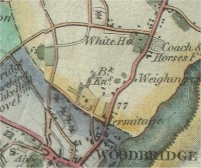
The first map to show Bury Hill in any detail is Bryant's 1826 map of Suffolk. An extract from this map is shown on the right and the area shaded yellow is part of Melton. Bury Hill is in the centre of the map and the layout of the roads around it does not appear to have changed.
In the bottom right hand corner is a house called Hermitage. To the left of it there is an L shaped building which is probably became The Grange. Nearby there is a Brick Kiln and, in 1818, Melton Hill was called Brick Kiln Hill.
In the top right had corner of the Bury Hill area there is the White House and its extensive gardens. It is believed that the Wood family had a house on this site since the sixteenth century.
Extract from Bryant's 1826 map of Suffolk.
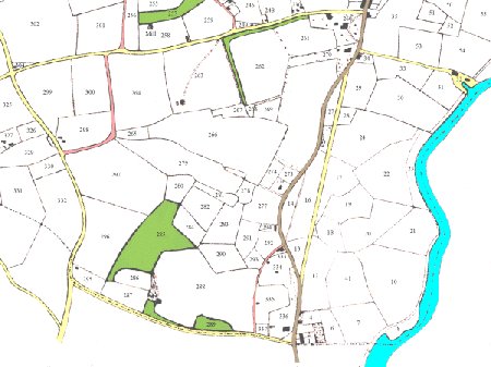
The map on the right is an extract from the 1840 tithe map of Melton. Bury Hill is the area enclosed by the roads shaded yellow. An expanded version of this map and the accompanying apportionment can be found by clicking on the line below.
Extracts from the 1840 Tithe Map and Apportionment.
The path shaded pink links Bredfield Road and Woods Lane. The path is not named yet it appears on both the Hodskinson and Bryant maps. This path still exits and it cuts through the present housing estate. It is from the unnamed path that people looked down and admired the beautiful valley which Bernard Barton, the nineteenth century Woodbridge poet, immortalised in his poem as "The Valley of Fern".
Until 1822 Pytches Road was known as Processional Way. It marked the boundary between Woodbridge and Melton and derives its earlier name from the procession which used to walk along the parish boundaries each year. The first evidence of a road along the Processional Way in Bryant's 1826 map. It does not appear on Hodskinson's 1783 map.
The road between Melton and Woodbridge was straightened in 1831. Part of the old Turnpike was left. It was joined to Pytches Road by Love Lane. The Valley of Fern runs up from Love Lane to Leek's Hill. Spencer Leek was landlord of the Green Man Inn at the end of Love Lane, and he held his renowned bullock sales in the adjoining meadow (Green Man Meadow) below the hill now carrying his name.
When Thomas Pytches II sold the Mount Pleasant Estate in 1839 its extent was as shown the map on the right. The areas woodland on the estate are shaded green while the rest of the estate is shaded navy blue. The thin black lines are the boundaries of some of the fields adjacent to the estate. The names of these fields will be referred to in the subsequent discussion. (The map and the field names are based on the 1837 tithe map and apportionment).
The Pytches’ estate lies within the area bounded by Pytches Road, Melton Road, Woods Lane and Bredfield Road. To the west of Woods Lane is Turnpike Lane which was created when the Melton to Woodbridge Turnpike was straightened in 1831. Turnpike Lane was linked to Pytches Road by Love Lane. The area bounded by the four main roads was eventually called Bury Hill.
The other large houses within this area were The Hermitage (now called Cedar House), Melton Mead, Melton Hall and Prospect House. Melton Mead, was the home of John Buckingham who also owned the Coach and Horses Inn across the road. Melton Hall was the home of John Wood, a solicitor, whose family had lived there from the sixteenth century and Woods Lane is named after them. Prospect House was owned by William Mason. These families, along with the Pytches, owned most of the land within the Bury Hill area.
The Pytches’ estate was in two parts which straddled Taylor’s Valley. This has been immortalised as The Valley of Fern by the poet Bernard Barton and the artist Thomas Churchyard. At the bottom of the valley a number of springs created a stream which flowed through the bottom of the Pytches’ estate and across Melton Road. The area containing the springs was called The Fen.
The slope on north side of Taylor’s Valley was called Whinney Hill but the part of the Pytches estate which abutted it was named Broom Hill. By the time the 1881 Ordnance Survey map was produced the area encompassing Whinney Hill and Broom Hill was being referred to a Leeks Hill after the landlord of the Green Man Inn which was at the bottom of Love Lane. He rented some of the Pytches’ meadow land near the Old Turnpike Road and used it for used for his popular bullock sales.
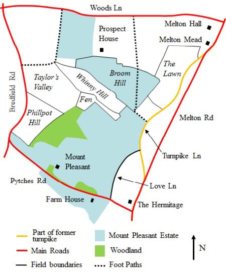
Map of the Mount Pleasant Estate and the surrounding area.
It is based on the tithe map which was produced in 1837.
There were two area of woodland in the lower part of the Pytches estate. The largest one was to the north of the mansion and the smaller one was along Pytches Road. There was also woodland in the grounds around Melton Hall, Melton Mead and Prospect House, and lines of trees marked most of the field boundaries.
The final features are two footpaths which are still in use today. One ran from Woods Lane, then along the eastern side of the grounds of Prospect House. It then crossed to northern part of the Pytches estate and ran down the boundary of the southern part of the estate to Turnpike Lane. The other footpath linked Bredfield Road and Woods Lane.
Soon after Dr Bland acquired the Pytches estate in 1839 he added a wing to the back of the mansion and laid out a formal garden with extensive glasshouses. He also sold the northern part of the estate to John Wood of Melton Hall and bought the land between Love Lane and Melton Road. After Dr Bland died in 1864 his daughter Jane retained the land below Love Lane but the rest of the estate was auctioned in 8 lots.
The lot comprising the farm house and the land to the west of Pytches Road was sold to Edward FitzGerald.
The mansion and the rest of the land were purchased by William Phillips and shortly after he changed the name from Mount Pleasant to Melton Grange. In 1884 he sold the house and estate to Major John Howey. A plan of the estate at that time has two features which seem to have been added after 1839. These were a wing on the back of the mansion and a formal garden, with extensive glasshouses.
Major Howey, the new owner, made major changes to the mansion in 1893. He built large extensions on either side of the mansion, extensive detached stables and a coach house. Also, in the eastern corner of the estate, he built Oak Cottage (now Turnpike House) for his butler.
The Army occupied Melton Grange during the Second World War. In 1947 it was bought by a Major Brown who made it into a Country Club which, two years later, became a hotel. The building was expanded in 1958 to provide a dinning room and in 1960 the kitchen was extended. Further extensions occurred in 1974 and some of the estate was sold to housing developers. These alterations to the mansion, along with those which occurred earlier, are all summarised by the plan shown on the right.

Plan showing the various stages of development
of Mount Pleasant (now Melton Grange)

Photographs of western elevation of Melton Grange when it was an Hotel (above) and after it was converted to private residences (right).

Changes to the Melton Grange Estate and the Surrounding area from 1839 to 1950
A map showing the key features of the Melton Grange Estate and the surrounding area in 1950 is shown on the right.
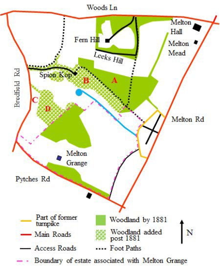
The 1881 Ordnance Survey map shows woodland, marked A, covering most of Broom Hill. Because the 1837 tithe apportionment describes this area as being arable land it would thus appear that the trees were planted after Broom Hill was sold to John Wood. Only a 100m wide strip adjoining the estate of Prospect House was left without trees.
In 1898, a mansion called Spion Kop was built on the northern edge of Tailor’s Valley and its grounds encompassed the valley, Whinney Hill and the Fen. There was also a tree line avenue leading to mansion. It went through the top of the area formerly known as Taylor's Valley.
The area marked B on the map had Pines and exotic conifers, including some large cedars and silver spruce, were planted between existing oaks which had become established along the bracken-covered sandy slope of Whinney Hill. Below it there is a small round pond which had been formed in the northern part of the marshy area. It was surrounded by rhododendrons, dogwood, bamboo, yellow flag irises, mimulus and alder. The southern area of the marsh was not touched. It remained a water meadow flanked by osier beds.
The name Spion Kop was later changed to Bury Hill House. Neither name had any local roots. It is thus rather odd that the whole area bounded by Woods Lane, Bredfield Road, Pytches Road and Melton Road is now called Bury Hill.
By the time the 1927 Ordnance Survey map was produced housing and a water-works had been erected on in the area marked C. The area was part of the land formerly called Phillpot Hill. The buildings abutted Bredfield Road and behind them the rest of Phillpot Hill was planted with trees. This plantation, marked D, was later called Godfrey’s Wood.
Click here for information on the Water Works.
In the 1930s a road called Leeks Hill was put in around the back Prospect House which by then was called Fern Hill. This road provided access to that part of Broom Hill which had not been planted with trees and number of large houses were eventually built along it. The woodland on Broom Hill, which the runs along the back of the gardens of these houses, was purchased jointly by the residents. It is only in recent years that attempts have been made to show that this woodland is private property
Map showing the key features of the Melton Grange Estate
and the surrounding area in 1950
In 1951 the woodland to the east of the footpath leading to Leeks Hill was given to Melton Parish Council by Sir Rowland and Lady Burke, the then owners of Melton Mead. Since then the area has been known as Burke’s Wood. The woodland was originally in that part of the Pytches estate which had been sold to John Wood.
In 1950 Sir Rowland and Lady Burke had sold the adjoining field to Melton Parish Council for use as a recreation ground. This field was part of what was had been called The Lawn in 1837. The remainder of the Lawn and some land behind Melton Hall was given to the Suffolk Wildlife Trust and they maintain it as a conservation meadow.
Fern Hill was used by the Agricultural board during WWII and was then left in a very poor condition. No buyer could be found so Fern Hill was demolished in 1951 and the estate became overgrown. At that time most of the Bury Hill area was still undeveloped. There were two large areas of woodland, a number of smaller ones and many trees lining the field boundaries. Between them were tracts of undulating meadow with a wealth of wild flowers and abundant wildlife. The area was, however, under threat.
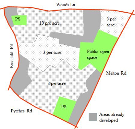
In 1951 a outline planning proposal was produced for Woodbridge and Melton. This included additional residential development in the Bury Hill area. These proposals were further expanded in the 1967 Woodbridge Development Plan which subdivided the underdeveloped parts of the Bury Hill area into four zones and set a separate housing density for each. A simplified version of this map is shown on the left. The map also shows two areas, marked PS, which were designated for primary schools. The one just below Melton Grange was for the rebuilding of the County Primary in New Street and the other, by the junction of Woods Lane and Bredfield Road, was for a new school. The only area not designated for development was the public open space given to the council by Sir Roland and Lady Burke.
Map showing the designated housing densities
for the Bury Hill area as set out in the 1967
Woodbridge Development Plan
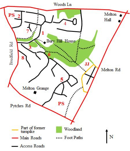
The roads were put in since 1966 to develop the Bury Hill from 1966 to 1977 shown by the map on the right. The numbers by the access roads will be used to describe the evolution of the housing development. The small gaps between some access roads indicate that they were laid out during different phases. The areas marked PS were designated for primary schools.
In 1966 an estate was built for the American servicemen and their families who were stationed at Woodbridge and Bentwaters airbases. The estate was at the end of a new road, Bury Hill (1), which linked it to Bredfield Road. The estate was built by a private company who leased the 150 houses to USAF. The lease came up for renewal in 1977 but terms could not be agreed and the properties were offered for sale in January 1978. Below Bury Hill there was a access road leading to Bury Hill House. It was eventually sold to developers in 1965.
In 1974/5 houses were built on Orchard Close (2). Part of this development was on the land previously designated for a primary school.
By then planning permission had also been granted to build houses down into the valley along Saxon Way and Norman Close (3). The houses at the top of Saxon Way were completed in 1977 but then the builder went into liquidation. Work started again in 1978 and a year later the final phase of this development had been completed.
Also in 1978, bungalows were built on a small plot of land abutting Turnpike Lane. This plot, which is marked JJ , had previously been used for allotments provided by the Melton Poors Estate Charity. The land had originally been given to the Church for the relief of the poor by John Jenner. It was sold 1973 and the Melton Poors Estate Charity invested the proceeds.
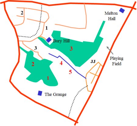
By this stage many people were beginning to express concern about impact of any further development to on the flora and fauna. The five areas under greatest threat are numbered in black on the above map to the right.
-
A coppice of sweet chestnuts some over 250 years old and an area of secondary woodland, with wych elm, hazel, maple, lime, broom and sycamore.
-
Another wood with boundary oaks between it and the coppice.
-
Some fine oak trees and a plantation of pines and exotic (i.e. not native) conifers, including some large cedars and silver spruce, which had been part of the garden of Bury Hill House
-
The upper marsh which had also once been in the was also part of the garden of Bury Hill House.
-
A water meadow.
In 1979 developer of the houses on the approach road to the Bury Hill estate and on Saxon Way and Norman Close, applied for planning permission to extend Saxon way and to build further down into the valley. This generated public protest about the impact on flora and fauna but sadly this was to no avail. As outline planning permission had already been granted, in 1975, for the woodland above Melton Grange the next stage of development was approved.
The next development phase started in 1983 on what had, at one time, been the grounds of Fern Hill. Fern Hill Close (4) was extended and houses were built along it. By then planning permission had also been sought to develop some of the land around Melton Grange. Despite public protest about the impact on flora and fauna, this application was eventually approved and the Melton Grange estate (5) was built between 1985 and 1989. Six years later Saxon Way was extended (6) to link up the developments at the top and bottom of the valley.
Simonds Close (7), a spur off Bury Hill, was laid out in 1986 and some land behind it was made into a small recreation area. Then, in 1996, houses were built along a road (8) which went into Godfrey’s Wood, the last untouched area of woodland above Melton Grange.
Most of the land designated as a new site for Woodbridge Primary School, remained empty until 2005. This land abutted Pytches Road and Love Lane. Plans to relocate the school from New Street to the designated site were announced by Suffolk County Council in 2001 but they were opposed by local residents. They argued that the previous sale of some of the plot for residential development had reduced the viability of the site for a school. They also had concerns about (i) the impact of traffic delivering and collecting children from school and (ii) the lack of adequate footpaths along Pytches Road. After a number of public consultations a formal planning application was submitted in January 2004 and was approved by the Council's Development Control Committee in July of that year. A footpath was put in along Pytches Road in May 2007 and the school opened in July 2007. (PS)
Development of the area is now complete and, although much of the original woodland has gone, what remains is enjoyed by the many people who walk through the footpaths which run through it.
In 2005/6 major changes were made to the recreation ground below the main area of woodland. Nine new pieces of play equipment and improved safety surfacing were installed. This equipment was designed for three distinct groups, 0-5, 6-12 and teenagers. An all weather pitch was also laid down and the pond on the fringes of the woods were thinned.
Map showing the access roads built in the Bury Hill
area for housing developments
Melton Grange Hotel was refurbished in 1998 but, a year later, it closed. Two years later it was sold to Charter Homes who, in 2003, made an outline planning application for change of use from commercial to residential. This application was rejected by Suffolk County Council on a number of grounds, the prime ones being that the loss of employment would be contrary to the Local Plan and that insufficient effort had been made to find a purchaser who would have a commercial application.
A revised application was made in 2004. It proposed the demolition of the twentieth century additions to the building and the conversion of the remainder to form 6 apartments. In addition 28 dwellings would be erected within the grounds. The application was largely supported by local residents and pressure groups who were concerned with the rapid degradation of the site, but was rejected by the planning authority. By then they were now prepared to accept residential development but were concerned about ‘the form, layout and type of housing proposed’.
The building become derelict as a result of several acts of vandalism and in June 2005 a fire broke out. The developer subsequently filed a revised proposal which was acceptable to the council and demolition of the modern parts of the building started in August 2005. When this was completed the northern wing was rebuilt in a style which was more sympathetic to the older core and new housing was erected in the grounds.
In 1987 permission was given to pull down the Rectory on Melton Road and replace it by a 3 story development of 13 flats. This imposing Victorian house, which appears on the 1881 Ordnance Survey map, was not used as a Rectory until sometime after 1922. It was demolished in 1989 and Old Rectory Court was completed the following year.
By 2000 only one of the areas designated for building remains undeveloped, namely the tract of land between Melton Grange Road and Wilkinson Way, which the 1975 Town Plan identified for the relocation of Woodbridge Country Primary School. Plans to move the school were presented to the public in 2002 but were then put on hold while attempts were made to improve access.
In 2001 Suffolk County Council and Greystoke and Everleigh Ltd. unveiled a scheme to relocate Woodbridge Primary School and Woodbridge Library. The School would be moved to the site, on the bottom of Pytches Road, as anticipated by the Local Plan of 1974.
Opposition from Melton residents were in the main based on the belief that the sale of some of the designated plot for residential development had reduced the viability of the site for a school and on concerns about (i) the impact of traffic delivering and collecting children from school and (ii) the lack of adequate footpaths along Pytches Road. After a number of public consultations a formal planning application was submitted in January 2004 and was approved by the Councils development control committee in July of that year. A footpath was put in along Pytches Road in May 2007 and the school opened in 2007.
In 2005/6 major changes were made to the children's play area on the Melton Recreation Ground. A £47,000 grant from Biffa award - fund established by Biffa Waste Services using its qualifying contributions under the landfill tax regulations. There were nine new pieces of play equipment and improved safety surfacing. The play equipment was aimed at three distinct groups 0-5, 6-12 and teenagers. The official opening was on 26th May 2006.
Last edited 8 Sept 23