Farlingaye and the Gazebo Farm Area
Introduction
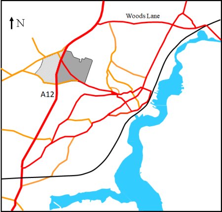
The 1967 Town Plan defines Farlingaye as the shaded grey on the map to the right. It is bounded by the A12, Hasketon Road and Grundisburgh Road.
For the purpose of this article it is also convenient to included the adjoining land, on the other side of the A12, which is also part of the parish of Woodbridge. This area, which is crosshatched, includes Gazebo farm and the parish pest houses.
Across the road from Gazebo farm there were two Pest Houses. These were purchase, by general subscription in 1755, following an outbreak of smallpox in the town. The Pest Houses are shown on Bryant's 1826 map.
A 1837 report by the Charity Commissioners reports "that the pest houses are now inhabited by paupers. The 1881 OS map also shows a third building marked Hospital (infectious diseases). The two pest houses were part of the endowment of the Poor's Houses Trust that was established in 1960 and they were sold in 1964. The third building appears to have been where Brafe engineering is now.
In 1802 the road from Woodbridge to Eye, via Otley and Debenham had been made a Turnpike. Two years later a tented barracks at Broomswell was replaced by a timber built barracks at Woodbridge. Troops from the barracks could march to defend either side of the Deben estuary against any invasion by the French. To alert the troops, two signal towers (Gazebos) were built. One was adjacent to the barracks and the second was by Gazebo farm. From these towers it was possible to communicate (by flags and telescopes) with similar towers at Felixstowe and Bawdsey.
When peace was declared in 1815 the barracks was pulled down immediately and sold for building material. The whole area soon reverted to farming and Gazebo Farm is the only reminder of that period.
Bryant's 1826 map also shows a mansion, called Fathing Cake Hall, which built in circa 1800. It is believed that the name is derived from the occupation of its owner, a wealthy Woodbridge baker who sold farthing gingerbread cakes at St. Audrey's Fair. The name has since become Farlingay Hall.
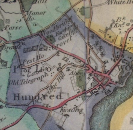
The first comprehensive view of Farlingaye and Gazebo Farm is given by the 1844 tithe map and the accompanying apportionment. An extract from the tithe map is shown on the right. It covers the Farlingaye area and some land to the west and the south. The buildings in the areas are numbered 1 to 6.
1 The toll-gate at the junction of Hasketon Road and the Melton to Bealings Road (19) was likely to be a Parish Tollgate which charged for entry to the market.
2 Across what is now the A12 there was a small brickworks (50). The Brickmaker’s Arms on Seckford Street was near to the intersection with Collett’s Walk which was the shortest route between the brickworks and the built up area of Woodbridge.
3 Two Pest House (56) had been purchased by general subscription in 1755 following an outbreak of smallpox in the town. The Town Books of 1761 gave an inventory for the Pest Houses which indication of greater comfort then in the workhouse. There were 9 bedsteads, 7 feather beds, 1 flock bed and 1 straw bed. A 1837 report by the Charity Commissioners reports "that the pest houses are now inhabited by paupers. The 1881 OS map shows a third building marked Hospital (infectious diseases). It appears to have been where Brafe engineering is now. The two former pest houses were eventually part of the endowment of the Poor's Houses Trust which was established in 1960. The two houses were sold by the Trust in 1964 and the proceeds were used to modernise the almshouses on New Street.
4 At the eastern end of Gazebo Lane there were two adjacent plots which indicate the presence of a farm. One plot was recorded as 'farm yards' (67) and the other was 'barn meadow' (69) Nearby there used to be a Gazebo (signalling tower) when the barracks were in Woodbridge. Later maps confirm that that Gazebo Farm was on the site.
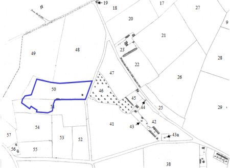
5 Most of the area of land in the centre of the extract of the tithe map was associated with Grove Farm. It was bounded by Hasketon Road, Grundisburgh Road and what is now part of the A12. Within it there is a large area of woodland called the Grove (46). At the bottom of the Grove there is the Grove farm yard (43) and a stack yard (43a) which abuts Grundisburgh Road. Between the Grove and Hasketon Road there is a garden (45) associated with the farm. The farm also had two large fields (41 and 42) described as clay pits. There is also a house and garden on a narrow strip of land (44) alongside Hasketon Road. It is not clear if this house is associated with the farm.
6 The building on this site was called Fathing Cake Hall. It is described as a "mansion, building ect" (23) and adjacent to it is a "canal piece" (22) , the later being a long and narrow lake. The owners of the mansion held large amount of land to east of Hasketon Road.
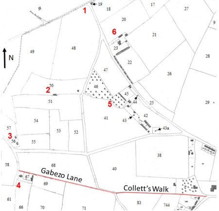
Annotated extract
of tithe map showing Farlingaye and
other parts of Woodbridge to the west and the south.

The one remaining Pest House is now a private residence.
By the time 1881 OS map was produced the brickworks on the western side of the A12 had expanded considerably. The extent of the brickworks is shown by the blue line on the map to on the right. For a while the brickworks flourished but, by the time the 1926 OS map was produced, the brickworks was marked as disused.
For a time the Local Boards of Health for Woodbridge used the old brickworks as a rubbish tip for the town. Few areas had efficient sewerage system so the biggest problem that many Local Boards had was how to cope with the disposal of the human faeces (excrement) that built up in the primitive outdoor toilets, the privies, that most urban dwellers used. The commonest way of disposing this smelly material was to have it collected at night. The men who did the work were euphemistically called the night soil men and their cart was referred to as the violet cart.
Notices were put up around the town explaining how the Woodbridge Local Board organized the collection night soil and household refuse. The later was predominantly ash from the fires and this would have been sent to the rubbish tip.
Everything else which was disposed of could be recycled and thus had a value. It would have been collected by rag and bone men.
The area outlined in blue shows the extent of the brickworks by 1881
The Suffolk Yeomanry were instructed to assemble in the town soon after war was declared in 1914. During the final months of 1914 they saw other troops, such as the 4th battalion of the Suffolk Regiment, being dispatched to the front from Woodbridge station.
The morale of the Suffolk Yeomanry declined with the onset of winter, which brought very muddy conditions to the stables. By then Grange Farm, on the Hasketon Road, had become the centre of their training. Army huts had been established for the men and a wooden shed for the horses. Eventually, proper stable huts with concrete floors solved the mud problem.
A letter card from “Grove Farm Camp – Woodbridge” has been recently been found. It is post marked 23rd December 1915 and it contains eight views of the town. The letter card would enabled soldiers billeted at the camp to give their relatives an idea of where they were. The photograph on the left shows a mounted soldier at Grange Farm.
The Yeomanry found life at Woodbridge with its drill and training very tedious but their moral was eventually lifted in July 1915 when they moved near to the sea by Leiston. There they camped in tents, with the horses being picketed in lines. The commanding officer regularly took the squadron down to the shore and he wrote that “bathing on horseback is a delight to experience ... Never before have we looked so Olympian, as when bestride our bare-back horses in a complete state of nudity”. He went on to say that the stretch of sea coast was remote and closed to the public."
From other sources it is clear that there was also a large summer camp at Broomswell. The troops came back from this, and other summer camps, to their billets in Woodbridge during the winter.
In early September 1915, the long-awaited departure orders arrived for the Suffolk Yeomanry but, because the need for cavalry was limited, they had to leave their horses behind.

A mounted soldier at Grange Farm Camp
In about 1918 George Buttrum, the then owner of the windmill on Burkitt road, bought the lower part of the Farlingaye estate from Edward Moor, and laid out what is now Moorefield Road and built himself a house on it (number 15). George Buttrum had married Catherine Ransom in 1926. It is in her memory that Catherine Road and Ransom Road are named. She died in 1926 and George died in 1937.
The A12 bypass was built in 1933. This scheme was one of a number instituted to bring employment. Between Hasketon Road and Grundisburgh Road the A12 roughly followed the line of older road.
In July 1839 the Woodbridge Magistrates backed the formation of a paid police force on the grounds that “the present system of parish constables has become inadequate to the due prevention and detection of offences against the Game Laws”. By the 6th February 1840 it was agreed to set up the East Suffolk Police – one of the oldest county constabularies in England. It was initially to have a chief constable, 3 superintendents and 60 constables. The ranks of inspectors and sergeants were introduced two years later. The headquarters of the force was at Yoxford.
The West Suffolk Police force was established in 1845. The two forces were merged in 1869. The combined force had a strength of about 208 and the headquarters was in Ipswich. When the East and West Suffolk county councils were set up in 1888 there was pressure to separate the two forces. Despite pressure from the Home Office the split did not occur and and it was not until 1966 that the East Suffolk, West Suffolk and Ipswich forces merged to become the Suffolk Constabulary.
By 1913 the Woodbridge Division comprised 21 constables, 2 sergeants, 2 inspectors, and a superintendent. From 1842 the Police Station was in the former House of Correction on Theatre Street but it moved to a new building on Grundisburgh Road in 1931.
Safer Neighbourhood Teams (SNTs) were introduced throughout Suffolk during March 2007. The Woodbridge Policing Sector had four SNTs covering Woodbridge, Melton, Ufford and Pettistree. These teams engaged with youth workers, housing associations and anti-social behaviour co-ordinators to identify and tackle problems which have been raised by the local community.
In about 1945 the stables at the southern part of the Grove farmyards was taken over by Houchell. His building company, which is still a flourishing, was adjacent to the Police Station.
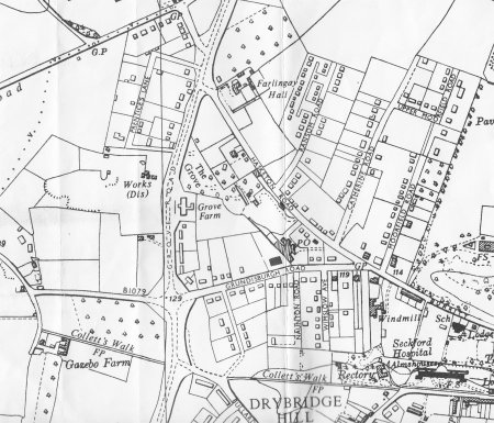
Map of Farlingaye and the surrounding area by 1950.
The above map of Farlingay and the surrounding area shows the that a considerable amount of housing had occurred by 1950. Most of the housing was along Moorfield Road, Catherine Road, Ransom Road, Upper Moorfield Road and Prentice Lane but it is clear that there was scope for further housing along these roads. Houses had also been erected along the northern side Grundisburgh Road and on part of the eastern side of the A12.
The area around Farlingay Hall remained undeveloped as did a large amount of the land associated with Grange Farm. To the east of Moorfield Road had been the grounds of Woodbridge Grammar School since 1865.
Changes from 1950 to the Present Day
Until 1954 most children in Woodbridge either attended the Country Infant and Primary schools at New Street or the National Voluntary Primary School in Burkett Road. Girls allocated to a Grammar School went to Framlingham Mills Grammar School, and the boys went to Woodbridge School. Those who did not go to Grammar School remained at their Primary School until they were 15.
Farlingaye Secondary Modern School was built, in 1954, on a site of approximately 11.5 acres which had previously been the Catherine Road Playing Field. The school had a three-form entry and could accommodate 300 children. By 1958 plans to build a second school in Melton were shelved and Farlingaye was expanded to provide four-form entry and space for 500 children.
Planning permission for Kingston Middle School was given in 1966/7. This enabled a three-tier school system to operate in Woodbridge until Kingston Middle School was closed in 1988 and a new teaching block was added to Farlingaye High School.
In 1950 a Service Station was erected on the A12 just below the Grove woodland. Sometime later a second Service Station was installed on the other side of the A12.
In 1975 The A12 bypass was widened to keep as much traffic as possible from coming through the centre of the town.
By 1989 Moor's Way, Tennyson Close, Grove Gardens and Hawthorn Close had been laid out and houses had been built along them. There is no space for further development other than either building extensions or replacing existing buildings.
In 2015 the police station 2015 was moved to into an extension of the Fire Station on Theatre Street. An extension which is diagonally opposite the former House of Correction. The old police station was sold for residential development.

AHT019 Return
Last edited 8 Sept 23