Warren Hill
The 1967 Town Plan defines Warren Hill as the area enclosed by Ipswich Rd., Warren Hill Rd., Portland Crescent, Fen Meadow Walk and Fen Walk. It includes the cluster of ten houses between Warren Hill and Portland Crescent along with the oldest of the two cemeteries and Notcutts Nursery.
A map of the area in 1950 is shown below. Most of the area is sloping to south-east as indicated by the 50ft and 100ft contour lines. The housing to the west of the cemeteries described in article on Peterhouse.

The 1560 Extent of the manor of Woodbridge late priory listed a number of people with the surname Warren and some held significant holdings of manorial land. So it is likely that the name Warren Hill is based on the Warren family.
In 1642, Robert Cade who had been minister at St Mary’s for sixteen years was asked to yield the pulpit to a number of preachers or ‘lecturers’ of whom at least were townsmen. Evidence of debate in the town, about who should preach in church, comes from the writing of Elizabeth Warren.
She was the daughter of John and Elizabeth Warren and she was baptized at Woodbridge in Suffolk on 19th December 1617. She is probably the Elizabeth Warren who married one John Mace at Woodbridge on 27th October 1641.

Map showing the Warren Hill area as defined
in 1967 Town Plan
Map of the Warren Hill area in 1950. The
red lines are the 50ft and 100 ft contours.
Elizabeth Warren's first tract was a defence of the ordained clergy against lay preachers. It was titled The Old and Good Way Vindicated and was published in 1646. It was followed a year later by a long work entitled Spiritual Thrift, comprising a series of meditations on religious themes. This reveals her to have been a well-educated woman who knew Latin and wrote well. Her third work, A Warning - Peece from Heaven against the Sins of the Times appeared in 1649. It was a lament on the breakdown of authority in the home, church, and state.
Elizabeth Warren displays an extraordinary amount of classical and theological learning, quoting Latin authors in the original, and by sermonizing she behaves as if she herself were a minister - a profession from which women would be excluded for another three centuries.
The extract from the 1840 tithe map on the right records the first significant change to the Warren Hill area. Plot 189 (outlined in green) was purchased by John Wood Jnr in 1784 and it became a nursery ground.
Plot 89 (outlined in red) is a small burial ground in the lower eastern corner of what is now the cemetery abutting Warren Hill Road. This is where the 669 men who died while stationed at the barracks were buried. The tombstone to them can be seen from the road.


Extract from the 1840 tithe map.
The Burial Board Act of 1854 authorised the setting up of Burial Boards outside London. Two years later the Woodbridge Vestry Minute Book records that the Burial Board for Woodbridge was in the process of creating a cemetery on the north-east side of Old Barrack Road.
William Pattison was commissioned to design the lodge and twin mortuary chapels. (Church of England and Non Conformist.) He was also asked to complete the burial ground by 'erecting the necessary buildings thereon and enclosing the same with an iron palisade along Dedman's Lane'. (Now Warren Hill Road.)
In 1864 the completed cemetery was described as covering 5 acres 'tastefully laid out with trees, shrubs and flowers', with two chapels in the Norman style. The Burial Board had, and continues to have, a close association with the Notcutt family and their nursery. The records show that the nursery regularly supplied plants, seeds, and flowers for the cemetery, and the family paid for and retain a hedged plot on the eastern boundary.
The earliest map of cemetery is shown on the right. It is taken from the 1881 OS map.
The cemetery ground is very undulating with a steep dip in the centre, and with a general rise from south to north. The layout of the cemetery is characterised by its series of interconnecting serpentine paths which take advantage of the significant changes in topography. The main drives from the entrance gates to the chapels are connected to each other by smaller paths which meander through the site, amongst headstones of a generally simple style set in grass which has been planted with a wide variety of both deciduous and coniferous trees. Many of the trees are of a size to suggest they are original plantings, and they include fine specimens of copper beech, cedar, pine, and lime, as well as a good number of mature clipped yews. Close to the northern boundary stands a very mature Cypressus macracarpa of great size. The wide variety of species and ages suggest that the cemetery has been continuously planted since it was consecrated in 1856, and the interesting and unusual range of tree species possibly reflects the past close relationship of the cemetery with the Notcutt nursery. The Notcutt family plot is located on the eastern boundary and is marked by a clipped yew hedge enclosing a simple sundial memorial.
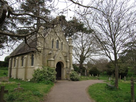
Both of the mortuary chapels fit comfortably within the wooded landscape.
A photograph of the nonconformist chapel is shown below.
In 1917 the Burial Board received a loan from the Local Government Board to purchase a piece of land to the create a cemetery beyond Cemetery Lane. To avoid confusion the two cemeteries will be referred to an northern and southern cemeteries. The northern cemetery is relatively flat and it its height above sea level only varies by 5ft. Whereas the smaller southern cemetery as height variations of about 30ft.
The boundary hedge and shrub collection were planted by Mr Notcutt whose widow, in 1939, complained of the dilapidated state of the fence and the ill health of the plants. Replacement and additional planting of trees continues to take place in both the old and new sections of the cemetery. The boundaries have remained unaltered since their creation and the site remains in public ownership.
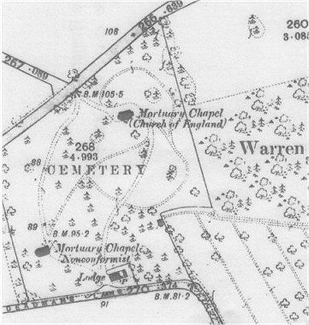
This extract from the 1881 OS maps shows the cemetery.
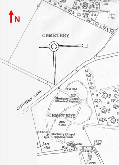
This extract from the 1926 OS maps shows
both the northern and southern cemeteries.
The earliest map John Wood's nursery is taken from the 1881 OS map and it is shown below. From this map it is clear that considerable effort had been put into dividing the nursery up into a number of strips. The land above the nursery would later also be purchased by John Wood.

This extract from the 1881 OS map is
the earliest map of the nursery.
Soon after Roger Notcutt bought Woods Nursery 1897 he recognised the urgency for fresh land because the original land had been cropped continuously with nursery stock for 150 years. So he set about acquiring land in and about Woodbridge. These plots of land are shaded yellow on the map below.
In 1899, Roger Notcutt rented Martlesham Field (Plot 3) was rented in 1899 and he eventually purchased it in 1931. Creek Farm (Plot 4) was rented in 1907 and was bought in 1925. The adjacent Sluice Farm (Plot 5) was purchased the following year. All this land had sandy soil, but not so that of the bankrupt Rose Nursery of Morse Brothers at Gazebo farm. Their land (Plot 6), which was purchased by Roger Notcutt in 1934, it had sticky heavy clay soil and staff received an extra 2d an hour for working there. Special handles were essential on spades as the ordinary ones soon broke. In 1950 Newfield (Plot 7) and Longfield (Plot 8) were purchased. They were either side of the A12 which was built in 1920 to provide employment for the town.
Map
showing the extent of Notcutt's
nursery grounds by 1958
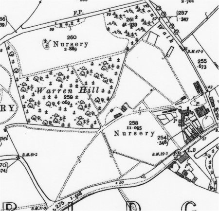
This extract from the 1904 OS map shows the
nursery after the addition land was acquired.
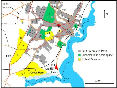
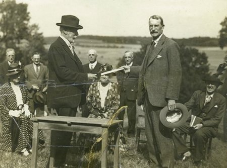
Broom Heath, which abuts Creek Farm was bought by Roger Notcutt in 1925. This land does not appear to have been incorporated into the nursery and in 1934 most of it was sold. The remaining four acres of parkland - shaded red on the above map, overlooked the meandering River Deben. This land was given to the National Trust in 1934 and ever since the magnificent views from there have been treasured by townspeople and visitors.
Roger Notcutts handing over the
deeds of part
of Broom Heath to the National Trust in 1934
.
During the Second World War there was a reduction in nursery staff. Fields were turned over the vegetables; five of the seven greenhouses grew tomatoes and the frames were full of cucumbers. Johnny Crane, a propagator, had only two green houses in which to save the precious stock of many plants. Despite his valiant efforts many varieties, including some of Roger Notcutt’s own introductions, were lost. By 1947 only 989 varieties were being grown.
The light soils of the nursery had been over cropped before the war and underfed during it. Plant growth was severely affected by the drought of 1947 and during the drought of 1949 stock began to die. Although demand was picking up there was little to sell. Some 50 years after Roger Notcutt bought the Nursery it nearly went out of business.
A new management team recognised that fresh land was needed, and it started to move production to heavier but workable soil. Two plots of such land in Woodbridge were purchased in 1950. They were either side of the A12 and were called Newfield and Longfield. The fertility of this land soon gave good stock for sale. Sluice Farm and Creek Farm were sold in 1953 and 54 respectively.
Newfield served the nursery well during the 1950’s but it 1965 it was sold for house building, thereby financing the purchase of more land and the acquisition of other garden centres. The medium light land needed for the expansion of the nursery lay more or less along the line of the A12 north of Woodbridge. The map on the right shows the locations of all the plots of land acquired after 1953. The last plot to be purchased was at Easton in 1986.
The plots of land which Notcutts purchased
or rented from 1950 to 1986.

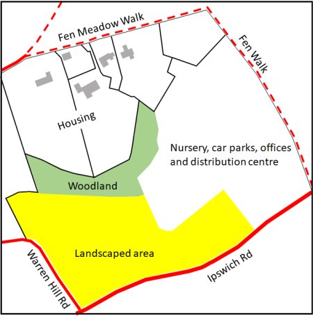
By 1989 five houses with large gardens had been built on the upper part of the nursery and the area shaded yellow on the map on the left had been attractively landscaped. The remaining third of the former nursery was being used for the Woodbridge Garden Centre. This had a large display and sales area, a car park, a distribution centre and offices.
The map on the left shows how the former
nursery was subdivided by 1989
In 2004 Notcutts applied for planning permission to redevelop some its land adjacent to the Woodbridge Garden Centre. Land abutted Ipswich Road and Warren Hill Road would be used for 76 retirement homes and land in the centre of the former nursery group would be used for a Medical Centre. Notcutts also wanted to erect houses on the rear part of Nursery and finally to build a new garden centre on the site of the old one.
Opposition to this proposal centred on the scale of the proposed buildings and the loss of an open space which had been attractively planted with shrubs and trees.
Planning permission was eventually given for all aspects of the development, but the scale of the retirement complex was cut back. The health centre opened in 2007 and Clarkson Court, which had 69 apartments, opened in 2008.

In 2007 Notcutts announced that, in the foreseeable future, it's garden centres would buy in all their plants from other growers. The nursery side of Notcutts was sold off to John Woods Nurseries, a new business set up by former Notcutts staff. The new company grew hardy plants on a 95 acre site at Pettistree. More than 1.3 million plants were produced each year and John Woods Nursery was one of the top five nurseries supplying garden centres in the UK. Sadly, the company went into administration on the 11 Nov 2015 and the Pettistree site is currently being diversified by the current owner.
In 2008 Notcutts purchased a chain of six garden centres in the North West. This brought the number of Notcutts Garden Centres up to 18. These garden centres continue to be run by the Notcutt family.
Work on building a new garden centre on the site of the old one started in 2019 and was completed by 2021.
AHT020 Return
Last edited 8 Sept 23