South Woodbridge
Introduction
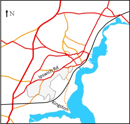
The 1967 Town Plan defines South Woodbridge as the shaded area on the map to the right. For most of its length South Woodbridge abuts Ipswich Road and then for a short distance it abuts Station Road and then Kingston Road.
Although South Woodbridge does not include what used to be the Royal manor of Kingston for the purpose of this article it will.
There used to be an ancient way linking Kingston to the Royal Hall at Rendlesham but all that remains of it is the footpath shown by the dotted line on the map to the right.
Wuffa, the first King of the East Angles, sailed up the river Deben to establish a Royal Hall somewhere in the area of Rendlesham.
The upper Deben valley became the heartland of Wuffinga's Royal Kingdom, and a cemetery at Sutton Hoo was probably used for the pagan ship burials of the entire Wuffinga dynasty, until they became Christian in the mid 7th century. Sutton Hoo is on a ridge that overlooks Woodbridge from the right hand side of the estuary.
On the left hand side of the estuary the Anglo-Saxons established the Royal Vill of Kingestuna, from which imported and exported goods were distributed. No traces of this Royal Vill remain, but it was probably somewhere in the area now called Kyson Point where there is a shallow landing area which was ideal for landing and launching longboats. From there the ground rises steeply to a plateau from which is possible to see far down the estuary and across to Sutton Hoo.
Woodbridge is first mentioned in a document, dated 959, in which King Edgar appointed an Abbot of Ely and enriched the monastery with the manor of Kingstuna (Kingston), and lands in Udedryeg (Woodbridge), Brightwell and Melton. After the Norman Invasion in 1066, King William transferred most of the land around Woodbridge to various Barons, but the ownership of Kingestuna remained with the monastery at Ely.
The 1560 Extent of the Manor of Woodbridge late Priory mentions the "common way leading to Kyngeston". In Saxon times it is likely that road would have been used to take goods landed at Kyngeston to the Royal Hall at Rendlesham. The exact route of this ancient way is not known but at least part of is likely to have followed what is now the footpath from Kyngeston to Woodbridge.
By 1560 most of the maritime trade of Woodbridge was centred on two embankments projecting into the estuary. There was also a third quay, referred to variously Le Lord's Caye and Le Quave, which was on land belonging to the manor of Hasketon. This quay appears to have been at a the near to Brook Slade lane. If so what of what is now called The Avenue and Jetty Lane could be what remains of Brook Slade lane.

Aerial view of the promontory which was the Royal Manor
of Kingston. The beach marked by the white arrow was
the ideal landing place for Saxon long ships.
Eventually the quay at Kyson Point was only used to lighten some of the ships destined for the Woodbridge Quays. The cargos removed at Kyson would have been taken to Woodbridge by waggon. Probably along part of the drift (an ancient way) which linked the hamlet of Kingston to Kingston Farm House and then to Woodbridge. Kingston Farm House and an adjacent barn (now a cottage) are believed to date from the seventeenth century.
By the time the railway arrived in 1859 most goods were carried by barges which did not need be lightened and the area around Kyson Point was being used by William Colchester and Company for a brick kiln and brick yard.
George Arnott, the eminent local historian, suggests that the name Maidensgrove is derived from Maidens Grave which appears on a 1804 map by Isaac Johnson. He goes on the say that "This is one of the many place-names in which the element 'maiden', appears, but why these places were so named is difficult to say. It has been noted that 'maiden' often appears in place-names in reference to an ancient road or earthwork."
In Woodbridge, Maidensgrove was probably near the junction of what is now Ipswich Road and Sandy Lane. North of this point the land rises rapidly to a plateau, known a Tempe Common, which is marked by a red dot of the map to the right.
Before houses were built on Tempe Common it commanded a fine view of the river and to beyond the Bowship Beacon which is where river pilots took over from the sea pilots. The area is called Tempe after the idyllic Vale of Tempe in Greece.
When a ship was sighted a pilot walk down an ancient footpath known as Pilot’s Way and then row out to meet. This footpath skirts an area of woodland which was at one time called Tempe Wood - one of the oldest areas of woodland within the town.
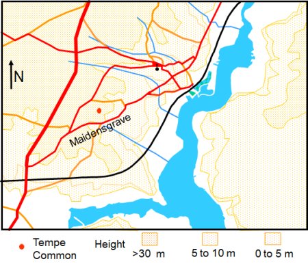
Map showing the locations of Maidensgrave and Tempe Common.
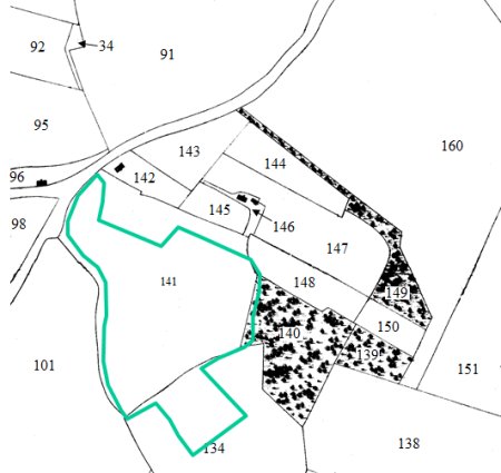
Tempe Wood did not exist when the 1840 Tithe map and apportionment were drawn up. The relevant extract from map is shown on the left and the boundary of the present wood is overlaid on the map in green. It encompassed most of plot 141 which was used by Wood's nursery.
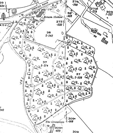
From extract from the 1881 map shown below it is clear that considerable progress had been made to turn plot 141 into woodland park. By the time to 1904 OS map was produced the work appears to be complete and by then the park was being called Tempe Wood.
Below Tempe Wood a house named The Crosstrees had been built.
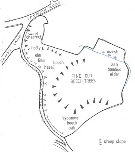
A 1990 map showing the planting scheme for Tempe Wood is shown on the right. Along the edge of the wood, where it abuts Pilot’s way, there are ancient oaks trees marking the boundary. They vary in age from about 80 to 400 years old. Lower down the sandy slope of the valley the wood is mainly beech, with sycamore, sweet chestnut, holly, hornbeam, hazel, lime and elm. The bottom of the wood is boggy and the ground is more clayey and in this area there are some alders and bamboo.
In the beech woods the leaf canopy is very dense, letting through very little light. Therefore there is very little undergrowth. However, in the spring, when the sunlight can get through, bulbous plants grow quickly producing a characteristic ground flora before the trees come into leaf. Some of the flowers to be found here include wood anemones, aconites, arum lilies, bluebells, celandines, ramsons, moschatel, primroses and yellow archangel.
The wood was given to the Woodland Trust by its former owner Dr Porter and its name was changed from Tempe Wood to Porter’s Wood.
This 1990 map shows the planting
scheme for Tempe Wood
Extract from the 1840 tithe map. Plot 141
was being used by Wood's Nursery.
Extract from the 1881 OS map showing the considerable
progress made to create a woodland park
The Impact of the Railway
When the railway was built in about 1858 it was necessary to dig a cutting which had a depth of about 18m at its deepest point. A decision was also made to layout Broomheath, a road which went from Sandy Lane to a bridge over the cutting and then down an incline to the riverside.
The map on the right is an extract from a 2010 OS map showing the land either side of Broomheath. By then the most of this land was being used for housing.
Most of the route of the new road would have been similar to that of the pilots way. It started at Tempe Common - roughly where the red dot is on map - and then skirted Tempe Wood and before joining Broomheath.
The only buildings shown on the 1881 OS map were a house on the site of the former brickyard at Kyson Point, a cottage further up the footpath to the railway bridge and a newly built house called The Crosstrees. The 1904 OS map showed little change since 1884.
The next house to be erected on Broomheath was Heath Lodge. It was built, sometime between in 1916 and 1927, as the retirement home for R H Rowland and his wife. In 1873 he had established a department store which sold a comprehensive range of goods. The business closed in 1936 and, sometime after the Second World War, the premises were taken over by F W Woolworth. No other houses were built along Broom Heath until after the Second World War.
To expand his nursery Roger Notcutt brought Broom Heath, which abuts, Creek Farm, to expand his nursery but he then sold most of it because more suitable land was available be found elsewhere. He retained four and a quarter acres of parkland on Kyson Hill and then given it to National Trust in 1934.
In 1963 the residents of the houses along Kyson Hill fought and won a court case against the Town Council. The resident claimed the road down the hill was private and had been trying to stop cars from going to the four acres of National Trust parkland. The Council had claimed that the provision of the bridge by the builders of the railway was an indication of more than occupational use. After the Court had decided in the favour of the residents there a long standing dispute about whether the end Kingston Wharf Road, which was now the driveway for the houses on the site of the old brickworks, could be still used by the public to gain access to Kyson Point when a high tide prevented access via the foreshore. Access along the road was subsequently denied. Then, in the 1980s, one of the residents laid claim to part of Kyson Point and erected fencing around it.

Extract from a 2010 OS map showing the land
either side of Broomheath.
By the 1970's there were houses with large gardens all the way down Broomheath.
Kyson point is now in private hands and the cost of reclaiming some of the nearby marsh land seems to be the only save-guard against building on it.
Housing Developments Elsewhere in South Woodbridge
By 1914 the housing development around St John’s Church was completed. Victoria road was then built and houses were erected on the slopes where the windmills once stood. Scattered building also took place on the Ipswich Road, near Drybridge Hill and along the Melton Road. All this development occurred during a period when the number of people living in the town remained static (at about 4300).
Woodbridge ceased to officially be classified as a port on the 31st March 1882 and new employment prospects within the town were scarce. Yet two retrospectives in Lambert’s Almanac around the turn of the century indicate that there was a shortage of housing. These retrospectives are reproduced on the right.
Retrospective on 1899 There is a great demand for middle-class and good houses. Application after application are constantly being made and only one answer can be given - none to be had. Something should be done in securing eligible sites and erecting a number of houses and thus tend towards the growth and further development of the town.
Retrospective on 1904 The suggestion which we threw out in our last retrospect as to the formation of a Building Company in the town has been taken up and energetically prosecuted. A Company - The Woodbridge Land and House Company - has been incorporated with a nominal capital of £10,000, and property situate on the Ipswich Road has been acquired after negotiations with Capt Pretyman, MP. The conditions of acquirement are that the rateable value of each house shall be not less than £27, that the frontages shall average about 50 feet, with 180 feet depth, possession to be given at Michaelmas. The first issue of 5,000 £1 shares will be subscribed for as follows: 1/- on application, 1/6 on allotment, and 2/6 at intervals. This Company is the outgrowth of the Traders' Association.
The map on right shows the housing which had occurred by 2020, and it makes a distinction between high density and low density housing. It also shows that there was a large area of pasture either side of the railway. This pasture was owned by Kingston Farm.
These following changes have taken place gradually.
By 1926 there been extensive house building along both sides of Ipswich Road. On the southern side of the road a pair of semidetached houses and a detached house had been built adjoining the Cheery Tree Inn. Part of Cherry Tree Road had been laid out and beyond it there was detached house and a semi-detached house. None of these homes were large and they all had small houses. Beyond this point and the entrance to Sandy Lane there was a number of large houses with extensive gardens.
There was also new housing on the northern side Ipswich Road beyond the entrance to Warren Hill Road. Most of these houses were detached and although they were large the gardens were significantly smaller than those on the southern side of Ipswich Road.
California, the road linking Ipswich Road and Sandy Lane, is shown on 1881 Ordnance Survey map but not on the 1844 tithe map. The road followed the parish boundary and linked York Cottage on the Ipswich Road with California Cottages on the other end. Presumably California Cottages were produced at the time of the California gold rush - 1848/49. Neither the California Cottages nor York Cottage appear on the 1844 tithe map.
The 1904 OS map shows that Briarwood had been build opposite York Cottage and two (semi-detached) houses had been built below the California Cottages. Riverview (6 terraced houses) had been built along Sandy Lane and there were few houses along the Ipswich Road between the entrances to Sandy Lane and California. The area to the south west of California (the area now known as Dukes Hill) was open fields.
Planning permission for Kingston Middle School was given in 1967 and this enabled a three-tier system to operate in Woodbridge from 1972 to 1988. After that the school buildings were demolished the Grove Court Retirement Home was erected on the site.
By 1973 Briarwood had been laid out in area that had been once been allotments. There had also been house building along Sandy Lane between the Ipswich Road and California. The final stage of the building is South Woodbridge was along Dukes Park.
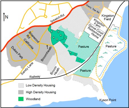
Map of South Woodbridge showing the extent of low and
high density housing by 2020 and what remained of
the land which belonged to Kingston Farm.
In 1987 the owners of Sluice Farm made a planning application build houses on 32 acres of land bounded by Sandy Lane, Ipswich Road and Dukes Park. In return for receiving planning permission they offered to donate 8.5 acres of land, between Sandy Lane and the railway, for use as a playing field. In addition, 39.45 acres of land to the south of Sandy Lane would be given as a public recreation area.
A counter proposal was made by Notcutts for a similar development on the triangle of land between the A12, the Ipswich Road and Seckford Hall Road. This plot of land - Martlesham Field - had been made into a nursery some time between 1881 and 1903.
The Sluice Farm application was turned down by SCDC and at the same time as they accepted the Notcutts one. The council indicated that refusal was "based on policy, amenity and highway grounds and that more favourable consideration may be given to a revised proposal relating solely to the recreational aspects.
According to 1840 tithe map and apportionment, most of land between what is now Broomheath, Sandy Lane, Ipswich Road, Kingston Road and The Avenue was owned by Thomas Salmon and was occupied by James Gobbet. All of this land was probably associated Kingston Farm which was taken over, sometime between 1910 and 1926, by Fred Smith and Company. The latter also owned Barrack Farm and it traded as the Suffolk Seed Establishment. Both farms produced seeds and they also had trial grounds.
Seed production in Woodbridge continued until the Suffolk Seed Establishment relocated to Framlingham in the 1970s. By then Kingston Farm was owed by Kingston Smith and it had a large amount of pasture above and below the railway. Parts of the pasture nearest the river were drained marshes where cattle grazed. The photograph on the right taken in about 1920 and it shows cattle grazing on beside the river wall.
Following severe flooding in 1955 the river walls were strengthened in 1962/3 but only to withstand a surge to be expected once in 20 years. By 1990 it was predicted that, with rising sea levels, the risk of a breach was as high as 1 in 10 years and work was started to raise the bank, from Kyson point to beyond Wilford Bridge, by 800 mm above the 1953 flood level. This reduced the risk of the towns flooding to once in 250 years but the extent of the drained marshes behind the river wall has not changed significantly.

There were cattle were grazing on marsh behind the river wall in
the early 1900s. Long before the river wall was raised in 1990.
Today the Kingston Smith family still own and run Kingston Farm and it has a large amount of pasture above and below the railway which supports a herd of cows.
When Fred Smith died in the late 1940s he bequeathed a 6.5 acre field, that abutted Kingston Way and Jetty Lane, to the Woodbridge Urban District with the condition that it became the Kingston Field Recreation Ground. Prior to this change most of the field was used as a market garden but there were also two tennis courts there.
In 1893 Dr Hubert Airy, a keen Deben Club member, presented the town with a small jetty adjacent to the Everson's Jetty. It became known as the Town Jetty and it had a white flagstaff and a mercury barometer. Today the Town jetty is much used for crabbing. In the same year, another of today's attraction were introduced to the river - a pair of mute swans.
The photograph on the right shows the Town Jetty soon after it was built and the photograph below shows the Jetty and the Bandstand which was built in 1904.

The above photograph shows the Town Jetty being used. It was
taken after the bandstand and shelters had been built.
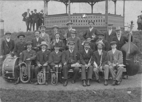
The photograph on the left shows a
band before a performance
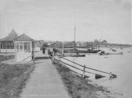
In this photograph shows the Town Jetty soon after it was presented to
the Town. The white rails either side of the Town Jetty are prominent.
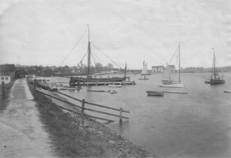
Everson's Jetty, the Town Jetty, the bandstand and
the two shelters and are shown in this photograph
The Council owned the adjacent 4.3 acre field that abutted Jetty Lane and the railway. It was on this field that the boating lake, sand pit and formal garden were laid out by 1927.
In 1934 the Deben Yacht Club decided to erect a clubhouse about 100 yards below the Town Jetty. In 1999 the clubhouse was raised 1 metre to reduce the risk of flooding.
The photograph on the right shows the boating lake, sand pit
and formal garden which were laid out by 1927.

AHT021 Return
Last edited 8 Sept 23